Mellieħa
| Mellieħa Il-Mellieħa | |||
|---|---|---|---|
| Local council | |||
| Il-Kunsill Lokali tal-Mellieħa | |||
|
Parish church - Mellieħa Maria Bambina | |||
| |||
 | |||
| Coordinates: 35°57′23″N 14°21′59″E / 35.95639°N 14.36639°ECoordinates: 35°57′23″N 14°21′59″E / 35.95639°N 14.36639°E | |||
| Country |
| ||
| Island | Malta | ||
| Borders | St. Paul's Bay, Mġarr | ||
| Government | |||
| • Mayor | Mr. John Buttigieg (PL) | ||
| Area | |||
| • Total | 22.6 km2 (8.7 sq mi) | ||
| Population (March 2013) | |||
| • Total | 10,003 | ||
| • Density | 440/km2 (1,100/sq mi) | ||
| Demonym | Mellieħi (m), Melliħija (f), Melliħin (pl) | ||
| Time zone | CET (UTC+1) | ||
| • Summer (DST) | CEST (UTC+2) | ||
| Postal code | MLĦ | ||
| Dialing code | 356 | ||
| Patron saint | Our Lady of Victories | ||
| Day of festa | 8 September | ||
| Website | |||
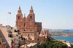

Mellieħa ([məˈliːhə], or il-Mellieħa) is a large village (pop. 10,003 in March 2013[1]) in the northwestern part of Malta. It is a popular tourist destination during the summer months. Mellieħa as a village developed under British colonization after the British encouraged people to settle in the area by giving leases to the population. For two centuries previously, the area was abandoned due to fear from attacks of corsairs and Saracens. Before that, only a few villagers lived in the area.
European Destinations of Excellence: 2009
The locality of Mellieħa has through its sustainable initiatives succeeded in achieving the 2009 title of excellence. http://ec.europa.eu/enterprise/sectors/tourism/eden/themes-destinations/countries/malta/mellieha-manikata/index_en.htm
Mellieħa main roads
- Dawret il-Mellieħa (Mellieħa By-Pass)
- Triq Ġorġ Borg Olivier (Ġorġ Borg Olivier Street)
- Triq il-Kbira (Main Street)
- Triq il-Marfa (Marfa Road)
- Triq il-Prajjiet (Anchor Bay Road)
- Triq Louis Wettinger (Louis Wettinger Street)
- Triq San Pawl il-Baħar (St. Paul's Bay Road)
Sister cities
References
- ↑ Estimated Population by Locality 31 March 2013. Malta Government Gazette 19,094. Retrieved 11 June 2014.
External links
| Wikimedia Commons has media related to Mellieħa. |
- Mellieħa Local Council official web site
- Mellieħa.info - Information site
- Mellieħa.com - Commercial & Information site
- Awarded "EDEN - European Destinations of Excellence" non traditional tourist destination 2009