Melara
| Melara | |
|---|---|
| Comune | |
| Comune di Melara | |
 Melara Location of Melara in Italy | |
| Coordinates: 45°4′N 11°12′E / 45.067°N 11.200°ECoordinates: 45°4′N 11°12′E / 45.067°N 11.200°E | |
| Country | Italy |
| Region | Veneto |
| Province | Province of Rovigo (RO) |
| Frazioni | Santo Stefano |
| Area | |
| • Total | 17.6 km2 (6.8 sq mi) |
| Population (Dec. 2004) | |
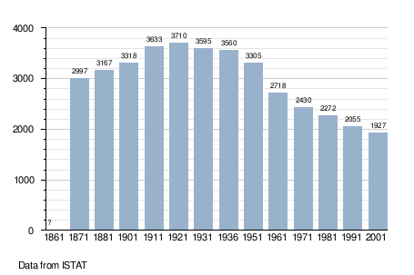
| • Total | 1,927 |
| • Density | 110/km2 (280/sq mi) |
| Demonym | Melaresi |
| Time zone | CET (UTC+1) |
| • Summer (DST) | CEST (UTC+2) |
| Postal code | 45037 |
| Dialing code | 0425 |
| Website | Official website |
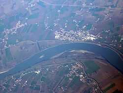
Aerial view of Melara
Melara is a comune (municipality) in the Province of Rovigo in the Italian region Veneto, located about 100 kilometres (62 mi) southwest of Venice and about 45 kilometres (28 mi) west of Rovigo. As of 31 December 2004, it had a population of 1,927 and an area of 17.6 square kilometres (6.8 sq mi).[1]
The municipality of Melara contains the frazione (subdivision) Santo Stefano.
Melara borders the following municipalities: Bergantino, Borgofranco sul Po, Cerea, Ostiglia.
Demographic evolution