Meknes
| Meknès مكناس | |
|---|---|
|
| |
| Nickname(s): meknes | |
 Meknès Location in Morocco | |
| Coordinates: 33°53′42″N 5°33′17″W / 33.89500°N 5.55472°WCoordinates: 33°53′42″N 5°33′17″W / 33.89500°N 5.55472°W | |
| Country |
|
| Region | Meknès-Tafilalet |
| Elevation[1] | 1,811 ft (552 m) |
| Population (2012) | |
| • Total | 750,000 |
| • Rank | 6th in Morocco |
Meknès (Arabic: مكناس, Berber: ⵎⴽⵏⴰⵙ Mknas or Meknas, French: Meknès, Spanish: Mequinez) is a city in northern Morocco. Meknes was the capital of Morocco under the reign of Moulay Ismail (1672–1727), before it was relocated to Marrakesh. The urban population is estimated at 650,000[2] with the metropolitan population close to 1,000,000. It is the capital of the Meknes-Tafilalet region. Meknes is named after a Berber tribe which was known as Miknasa (native Berber name: Imeknasen) in the medieval North African sources.
| Historic City of Meknes | |
|---|---|
| Name as inscribed on the World Heritage List | |
 | |
| Type | Cultural |
| Criteria | iv |
| UNESCO region | Arab States |
| Inscription history | |
| Inscription | 1996 (20th Session) |
History
A Berber tribe called the Miknasa, originally from the Tunisian south, settled here in the 9th century.
The Almoravids founded a fortress here in the 11th century. It resisted the Almohads rise, and was thus destroyed by them, only to be rebuilt in a larger size with mosques and large fortifications. Under the Merinids it received further madrasas, kasbahs and mosques in the early 14th century, and continued to thrive under the Wattasid dynasty. Meknes saw its golden age as the imperial capital of Moulay Ismail following his accession to the Sultanate of Morocco (1672–1727). He installed under the old city a large prison to house Christian sailors captured on the sea, and also constructed numerous edifices, gardens, monumental gates, mosques (whence the city's nickname of "City of a Hundred Minarets") and the large line of wall, having a length of 40 kilometres (25 miles).
According to the ICOMOS Heritage at Risk report of 2000, the historic city of Meknes contains insufficient drainage systems, and as a result suffers from inundation and leakage in certain areas.[3]
Geography
Neighboring cities to the south: Azrou, connecting via the N13 road, is a cedar region with the noted "College d'Azrou" where many members of the post-independence elite derived); and Ifrane (Al Akhawayn University).
Climate
Located near the Atlas Mountains, Meknes has a seasonal climate, shifting from cool in winter to hot days in the summer months of June–September. The nights are always cool (or colder in winter), with daytime temperatures generally rising 10-14ºC (or 15-28ºF) above the low every day. The winter highs typically reach only 15.5 °C (60 °F) in December–January (see weather-table below).
| Climate data for Meknes | |||||||||||||
|---|---|---|---|---|---|---|---|---|---|---|---|---|---|
| Month | Jan | Feb | Mar | Apr | May | Jun | Jul | Aug | Sep | Oct | Nov | Dec | Year |
| Average high °C (°F) | 15.3 (59.5) |
16.6 (61.9) |
18.6 (65.5) |
20.0 (68) |
23.8 (74.8) |
27.8 (82) |
32.7 (90.9) |
32.6 (90.7) |
29.6 (85.3) |
24.5 (76.1) |
19.3 (66.7) |
15.6 (60.1) |
23.0 (73.4) |
| Daily mean °C (°F) | 10.2 (50.4) |
11.5 (52.7) |
12.9 (55.2) |
14.4 (57.9) |
17.7 (63.9) |
21.2 (70.2) |
25.2 (77.4) |
25.3 (77.5) |
22.9 (73.2) |
18.7 (65.7) |
14.2 (57.6) |
10.7 (51.3) |
17.1 (62.8) |
| Average low °C (°F) | 5.2 (41.4) |
6.3 (43.3) |
7.2 (45) |
8.8 (47.8) |
11.5 (52.7) |
14.6 (58.3) |
17.7 (63.9) |
17.9 (64.2) |
16.2 (61.2) |
12.8 (55) |
9.1 (48.4) |
5.8 (42.4) |
11.1 (52) |
| Average precipitation mm (inches) | 89.4 (3.52) |
84.4 (3.323) |
78.4 (3.087) |
74.3 (2.925) |
42.6 (1.677) |
12.5 (0.492) |
2.1 (0.083) |
1.9 (0.075) |
14.1 (0.555) |
47.4 (1.866) |
79.6 (3.134) |
81.2 (3.197) |
607.9 (23.933) |
| Avg. precipitation days | 10.5 | 10.1 | 9.9 | 10.3 | 7.3 | 3.5 | 0.9 | 1.4 | 3.4 | 7.6 | 9.8 | 9.6 | 84.3 |
| Mean monthly sunshine hours | 174.3 | 176.2 | 226.6 | 236.9 | 283.4 | 305.5 | 347.8 | 328.4 | 264.4 | 227.7 | 176.5 | 165.8 | 2,913.5 |
| Source: NOAA[4] | |||||||||||||
Quarters
|
|
Prefecture
Meknes is the seat of the prefecture of Meknès, which consists of 6 municipalities (including the city Meknes) and 15 rural communes.[5]
Main sights


- Dar El Makhzen palace, located in El Mechouar Stinia. It is sided by a 2 km-long corridor formed by two large walls. It was Moulay Ismaïl's official palace.
- Bab Mansour gate, named after the architect, El-Mansour. It was completed 5 years after Moulay Ismail's death, in 1732. The design of the gate plays with Almohad patterns. It has zellij mosaics of excellent quality. The marble columns were taken from the Roman ruins of Volubilis. When the structure was completed, Moulay Ismail inspected the gate, asking El-Mansur if he could do better. El-Mansur felt complied to answer yes, making the sultan so furious he had him executed. Still, according to historical records, the gate was finished after Moulay Ismail's death. The gate itself is now used as an arts and crafts gallery; entry is by a side gate.
- Lahboul gardens. It houses a zoological garden and an open-air theatre.
- Mausoleum of Moulay Ismail, built in 1703 by Ahmed Eddahbi
- Néjjarine Mosque (10th century), located in the old city.
- The Grand Mosque, founded in the 11th century by the Almoravids. It has 11 gates and 143 arcades.
- Koubat Al Khayatin ("Ambassador's Hall"): a pavilion in which sultan Moulay Ismaïl received foreign ambassadors.
- Bab Lakhmis: a large decorated gate from the 17th century.
- Bab Berdaïne: a majestic gate built by Moulay Ismaïl in the 17th century.
- Dar El Beida, a 19th-century palace built by sultan Mohammed ben Abdallah. It is currently home to the Royal Military Academy.
- Royal stables
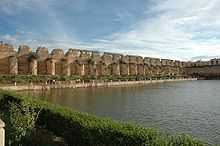
- Agdal reservoir, built by Moulay Ismail. It measures 319 x 149 meters, with a depth of 2 m.
- Cara subterranean prison.
The ruins of the Roman town of Volubilis (Oualili) are about half an hour to the north.
Industry
There are 171 industrial units in Meknes, employing 10,358 people. The chief industries are food processing, textile manufacturing, chemical and para-chemical industry, and metallic and mechanical industry.
Bab Berdieyinne mosque
The Bab Berdieyinne mosque (Arab: بردعين, French: Berdaïne), constructed in the 17th century, is located in the historical city center. On 19 February 2010, its minaret collapsed during Friday prayers, causing at least 41 fatalities and many injuries. The area had received heavy rain over the preceding days. King Mohammed VI ordered the minaret be rebuilt according to historical specifications.[6][7]
International relations
Twin towns – Sister cities
Meknes is twinned with:
References
- ↑ "Climatological Information for Meknes, Morocco", Hong Kong Observatory, 2003, web: HKO-Meknes.
- ↑ Template:Largest cities of Morocco
- ↑ ICOMOS Heritage at Risk 2000
- ↑ "Meknes Climate Normals 1961–1990". National Oceanic and Atmospheric Administration. Retrieved March 16, 2015.
- ↑ Royaume du Maroc (20 November 2008). "Bulletin Officiel № 5684" (PDF) (in French). p. 1600. Retrieved 15 July 2012.
- ↑ "Minaret collapse kills 36 in Morocco". CNN. 20 February 2010.
- ↑ Morocco minaret collapse toll rises to 41, Hindustan Times, 20 February 2010
External links
| Wikimedia Commons has media related to Meknes. |
- MeknesCity Newspaper
 Meknes travel guide from Wikivoyage
| |||||||||||||||||
| ||||||||||||||||