Megatsunami
Megatsunami is an informal term to describe a tsunami that has initial wave heights that are much larger than normal tsunamis. Unlike usual tsunamis – which originate from tectonic activity and the raising or lowering of the sea floor – known megatsunamis have originated from a large-scale landslide, collision, or volcanic eruption event.
Concept
A megatsunami is meant to refer to a tsunami with an initial wave amplitude (height) measured in several tens, hundreds, or possibly thousands of meters.
Normal tsunamis generated at sea result from movement of the sea floor. They have a small wave height offshore, and a very long wavelength (often hundreds of kilometers long), and generally pass unnoticed at sea, forming only a slight swell usually of the order of 30 cm (12 in) above the normal sea surface. When they reach land the wave height increases dramatically as the base of the wave pushes the water column above it upwards.
By contrast, megatsunamis are caused by giant landslides and other impact events. This could also refer to a meteorite hitting an ocean. Underwater earthquakes or volcanic eruptions do not normally generate such large tsunamis, but landslides next to bodies of water resulting from earthquakes can, since they cause a massive amount of displacement. If the landslide or impact occurs in a limited body of water, as happened at the Vajont Dam (1963) and Lituya Bay (1958) then the water may be unable to disperse and one or more exceedingly large waves may result.
Two heights are sometimes quoted for megatsunamis – the height of the wave itself (in water), and the height to which it surges when it reaches land, which depending upon the locale, can be several times larger.
History of the hypothesis
Geologists searching for oil in Alaska in 1953 observed that in Lituya Bay, mature tree growth did not extend to the shoreline as it did in many other bays in the region. Rather, there was a band of younger trees closer to the shore. Forestry workers, glaciologists, and geographers call the boundary between these bands a trim line. Trees just above the trim line showed severe scarring on their seaward side, whilst those from below the trim line did not. The scientists hypothesized that there had been an unusually large wave or waves in the deep inlet. Because this is a recently deglaciated fjord with steep slopes and crossed by a major fault, one possibility was a landslide-generated tsunami.[1]
On 9 July 1958, an earthquake of magnitude 7.7–8.3[2] (on the Richter scale) caused 90 million tonnes of rock and ice to drop into the deep water at the head of Lituya Bay. The block fell almost vertically and hit the water with sufficient force to create a wave up to 1720 feet (524 m) high. Howard Ulrich and his son, Howard Jr., were in the bay in their fishing boat when they saw the wave. They both survived and reported that the wave carried their boat "over the trees" on one of the initial waves which washed them back into the bay. [1]
List of megatsunamis
Prehistoric
- The asteroid which created the Chicxulub crater in Yucatán approximately 66 million years ago would have generated megatsunamis as high as 5 kilometres (3.1 mi), enough to completely inundate even large islands such as Madagascar.[3]
- A series of megatsunamis were generated by the bolide impact that created the Chesapeake Bay impact crater, about 35.5 million years ago.[4]
- An asteroid impact in the southeast Pacific Ocean 2.5 million years ago caused a megatsunami that was over 200 m (660 ft) high in southern Chile and the Antarctic Peninsula; the wave swept across much of the Pacific Ocean.
- The northern half of the East Molokai Volcano suffered a catastrophic collapse and likely megatsumami about 1.5 million years ago and now lies as a debris field scattered northward across the ocean bottom,[5] while what remains on the island are the highest sea cliffs in the world.[6]
- A massive collapse of the western edge of the Lake Tahoe basin, which formed McKinney Bay around 50,000 years ago, is thought to have generated a tsunami/seiche wave with a height approaching 330 ft (100 m).[7]
- At Seton Portage, British Columbia, Canada, a freshwater megatsunami may have occurred approximately 10,000 years ago.[8] A huge block of the Cayoosh Range suddenly slid northwards into what had been a large lake spanning the area from Lillooet, British Columbia to near Birken, in the Gates Valley or Pemberton Pass to the southwest.
- Approximately 8,000 years ago, a massive volcanic landslide off of Mt. Etna, Sicily caused a megatsunami which devastated the eastern Mediterranean coastline on three continents.[9]
- In the Norwegian Sea, the Storegga Slide caused a megatsunami approximately 8,000 years ago.[10]
- Approximately 6,000 years ago, a landslide on Réunion island, to the east of Madagascar, may have caused a megatsunami.[11]
Modern
1792: Mount Unzen, Japan
In 1792, Mount Unzen in Japan erupted, causing part of the volcano to collapse into the sea. The landslide caused a megatsunami that reached 100 metres (330 ft) high and killed 15,000 people in the local fishing villages.
1958: Lituya Bay, Alaska, USA
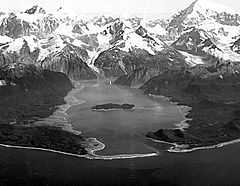
On 9 July 1958, a giant landslide at the head of Lituya Bay in Alaska, caused by an earthquake, generated a wave with an initial amplitude of up to 520 metres (1,710 ft). This is the highest wave ever recorded, and surged over the headland opposite, stripping trees and soil down to bedrock, and surged along the fjord which forms Lituya Bay, destroying a fishing boat anchored there and killing two people. Howard Ulrich and his son managed to ride the wave in their boat, and both survived.[1]
1963: Vajont Dam, Italy
On 9 October 1963, a landslide above Vajont Dam in Italy produced a 250 m (820 ft) surge that overtopped the dam and destroyed the villages of Longarone, Pirago, Rivalta, Villanova and Faè, killing nearly 2,000 people.[12]
1980: Spirit Lake, Washington, USA
On May 18, 1980, the upper 460 meters (1,509 feet) of Mount St. Helens failed and detached in a massive landslide. This released the pressure on the magma trapped beneath the summit bulge which exploded as a lateral blast, which then released the over-pressure on the magma chamber and resulted in a plinian eruption.
One lobe of the avalanche surged onto Spirit Lake, causing a megatsunami which pushed the lake waters in a series of surges, which reached a maximum height of 260 meters (853 feet)[13] above the pre-eruption water level (~975 m asl/3,199 ft). Above the upper limit of the tsunami, trees lie where they were knocked down by the pyroclastic surge; below the limit, the fallen trees and the surge deposits were removed by the megatsunami and deposited in Spirit Lake.[14]
Potential future megatsunamis
Experts interviewed by the BBC think that a massive landslide on a volcanic ocean island is the most likely future cause of a megatsunami.[15] The size and power of a wave generated by such means could produce devastating effects, travelling across oceans and inundating up to 25 kilometres (16 mi) inland from the coast.
British Columbia
Some geologists consider an unstable rock face at Mount Breakenridge, above the north end of the giant fresh-water fjord of Harrison Lake in the Fraser Valley of southwestern British Columbia, Canada, to be unstable enough to collapse into the lake, generating a megatsunami that might destroy the town of Harrison Hot Springs (located at its south end).[16]
Canary Islands
Geologists Dr. Simon Day and Dr. Steven Neal Ward consider that a megatsunami could be generated during a future eruption of Cumbre Vieja on the volcanic ocean island of La Palma, in the Canary Islands, Spain.[17][18]
In 1949, this volcano erupted at its Duraznero, Hoyo Negro and Llano del Banco vents, and there was an earthquake with an epicentre near the village of Jedy. The next day Juan Bonelli Rubio, a local geologist, visited the summit area and found that a fissure about 2.5 kilometres (1.6 mi) long had opened on the east side of the summit. As a result, the west half of the volcano (which is the volcanically active arm of a triple-armed rift) had slipped about 2 metres (6.6 ft) downwards and 1 metre (3.3 ft) westwards towards the Atlantic Ocean,[19]
Cumbre Vieja is currently dormant, but will almost certainly erupt again. Day and Ward hypothesize[17][18] that if such an eruption causes the western flank to fail, a mega-tsunami could be generated.
La Palma is currently the most volcanically active island in the Canary Islands Archipelago. It is likely that several eruptions would be required before failure would occur on Cumbre Vieja.[17][18] However, the western half of the volcano has an approximate volume of 500 cubic kilometres (120 cu mi) and an estimated mass of 1.5 trillion metric tons (1.7×10¹² short tons). If it were to catastrophically slide into the ocean, it could generate a wave with an initial height of about 1,000 metres (3,300 ft) at the island, and a likely height of around 50 metres (164 ft) at the Caribbean and the Eastern North American seaboard when it runs ashore eight or more hours later. Tens of millions of lives could be lost in the cities and/or towns of St. John's, Boston, Halifax, New York, Baltimore, Washington, D.C., Miami, Havana and the coasts of both South Carolina and North Carolina, as well many other cities on the Atlantic coast in Europe, South America and Africa.[17][18] The likelihood of this happening is a matter of vigorous debate.[20]
The last eruption on the Cumbre Vieja occurred in 1971 at the Teneguia vent at the southern end of the sub-aerial section without any movement. The section affected by the 1949 eruption is currently stationary and does not appear to have moved since the initial rupture.[21]
Geologists and volcanologists are in sharp disagreement about whether an eruption on the Cumbre Vieja would cause a single large gravitational landslide or a series of smaller landslides, or whether a slide is likely at all. There are also questions about the dynamics. Day and Ward have admitted that their original analysis of the danger was based on several worst case assumptions.[22][23]
Hawaii
Sharp cliffs and associated ocean debris at the Kohala Volcano, Lanai and Molokai indicate that landslides from the flank of the Kilauea and Mauna Loa volcanoes in Hawaii may have triggered past megatsunamis, most recently at 120,000 BP.[24][25][26] A future tsunami event is also possible, with the tsunami potentially reaching up to about 1 kilometre (3,300 ft) in height.[27][28] According to a documentary called National Geographic's Ultimate Disaster: Tsunami, if a big landslide occurred at Mauna Loa or the Hilina Slump, a 30 metres (98 ft) tsunami would take only thirty minutes to reach Honolulu, Hawaii. There, hundreds of thousands of people could be killed as the tsunami could level Honolulu and travel 25 kilometres (16 mi) inland.
Cape Verde Islands
Steep cliffs on the Cape Verde Islands have been caused by catastrophic debris avalanches. These have been common on the submerged flanks of ocean island volcanoes and more can be expected in the future.[29]
See also
- Historic tsunamis
- La Palma
- Cumbre Vieja
- Minoan eruption
- 2004 Indian Ocean Earthquake
- Tsunamis in lakes
References
- ↑ 1.0 1.1 1.2 Miller, Don J. "Giant Waves in Lituya Bay, Alaska". uwsp.edu. p. 3. Archived from the original on 13 October 2014.
- ↑ "Juneau, Alaska profile". City-Data.com.
- ↑ "Armageddon" Episode 2.3 (2007) of Lost Worlds, The History Channel, original air date: 15 August 2007.
- ↑ Poag, C. W. (1997). "The Chesapeake Bay bolide impact: A convulsive event in Atlantic Coastal Plain evolution". Sedimentary Geology 108 (1–4): 45–90. Bibcode:1997SedG..108...45P. doi:10.1016/S0037-0738(96)00048-6.
- ↑ "Hawaiian landslides have been catastrophic". mbari.org. Monterey Bay Aquarium Research Institute.
- ↑ Culliney, John L. (2006) Islands in a Far Sea: The Fate of Nature in Hawaii. Honolulu: University of Hawaii Press. p. 17.
- ↑ Gardner, J.V. (July 2000). "The Lake Tahoe debris avalanche". 15th Annual Geological Conference. Geological Society of Australia.
- ↑ "SetonPortage.ca website".
- ↑ Pareschi, M. T.; Boschi, E.; Favalli, M. (2006). "Lost tsunami". Geophysical Research Letters 33 (22): L22608. Bibcode:2006GeoRL..3322608P. doi:10.1029/2006GL027790.
- ↑ Bondevik, S.; Lovholt, F.; Harbitz, C.; Mangerud, J.; Dawsond, A.; Svendsen, J. I. (2005). "The Storegga Slide tsunami—comparing field observations with numerical simulations". Marine and Petroleum Geology 22 (1–2): 195–208. doi:10.1016/j.marpetgeo.2004.10.003.
- ↑ "Mega-tsunami: Wave of Destruction". BBC Two. 12 October 2000.
- ↑ http://www.uwsp.edu/geo/projects/geoweb/participants/Dutch/VTrips/Vaiont.HTM Vaiont Dam photos and virtual field trip (University of Wisconsin), retrieved 2009-07-01
- ↑ Voight et al. 1983
- ↑ USGS Website. Geology of Interactions of Volcanoes, Snow, and Water: Tsunami on Spirit Lake early during 18 May 1980 eruption
- ↑ Mega-tsunami: Wave of Destruction. Transcript. BBC Two television programme, first broadcast 12 October 2000
- ↑ Evans, S.G.; Savigny, K.W. (1994). "Landslides in the Vancouver-Fraser Valley-Whistler region" (PDF). Geological Survey of Canada. Ministry of Forests, Province of British Columbia. pp. 36 p. Retrieved 2008-12-28.
- ↑ 17.0 17.1 17.2 17.3 Day et al. 1999
- ↑ 18.0 18.1 18.2 18.3 Ward & Day 2001
- ↑ Bonelli 1950
- ↑ Pararas-Carayannis 2002
- ↑ As per Bonelli Rubio
- ↑ Ali Ayres (2004-10-29). "Tidal wave threat 'over-hyped'". BBC NEWS.
- ↑ Pararas-Carayannis, George (2002). "Evaluation of the threat of mega tsunami generation from postulated massive slope failures of the island volcanoes on La Palma, Canary Islands, and on the island of Hawaii". Science of Tsunami Hazards 20 (5): 251–277. Retrieved 7 September 2014.
- ↑ McMurtry, Gary M.; Fryer, Gerard J.; Tappin, David R.; Wilkinson, Ian P.; Williams, Mark; Fietzke, Jan; Garbe-Schoenberg, Dieter; Watts, Philip (1 September 2004). "Megatsunami deposits on Kohala volcano, Hawaii, from flank collapse of Mauna Loa". Geology 32 (9): 741. Bibcode:2004Geo....32..741M. doi:10.1130/G20642.1.
- ↑ McMurtry, Gary M.; Fryer, Gerard J.; Tappin, David R.; Wilkinson, Ian P.; Williams, Mark; Fietzke, Jan; Garbe-Schoenberg, Dieter; Watts, Philip (September 1, 2004). "A Gigantic Tsunami in the Hawaiian Islands 120,000 Years Ago". Geology, Volume 32. SOEST Press Releases. Retrieved 2008-12-20.
- ↑ McMurtry, G. M.; Tappin, D. R.; Fryer, G. J.; Watts, P. (December 2002). "Megatsunami Deposits on the Island of Hawaii: Implications for the Origin of Similar Deposits in Hawaii and Confirmation of the 'Giant Wave Hypothesis'". AGU Fall Meeting Abstracts 51: 0148. Bibcode:2002AGUFMOS51A0148M.
- ↑ Pararas-Carayannis, George (2002). "Evaluation of the threat of mega tsunami generation from postulated massive slope failures of island volcanoes on La Palma, Canary Islands, and on the island of Hawaii". drgeorgepc.com. Retrieved 2008-12-20.
- ↑ Britt, Robert Roy (14 December 2004). "The Megatsunami: Possible Modern Threat". LiveScience. Retrieved 2008-12-20.
- ↑ Le Bas, T.P. (2007). "Slope Failures on the Flanks of Southern Cape Verde Islands". In Lykousis, Vasilios. Submarine mass movements and their consequences: 3rd international symposium. Springer. ISBN 978-1-4020-6511-8
Further reading
- BBC 2 TV; 2000. Transcript "Mega-tsunami; Wave of Destruction", Horizon. First screened 21.30 hrs, Thursday, 12 October 2000.
- Carracedo, J.C. (1994). "The Canary Islands: an example of structural control on the growth of large oceanic-island volcanoes". J. Volcanol. Geotherm Res. 60 (3–4): 225–241. Bibcode:1994JVGR...60..225C. doi:10.1016/0377-0273(94)90053-1.
- Carracedo, J.C. (1996). "A simple model for the genesis of large gravitational landslide hazards in the Canary Islands". In McGuire, W; Jones; Neuberg, J.P. Volcano Instability on the Earth and Other Planets. Special Publication 110. London: Geological Society. pp. 125–135.
- Carracedo, J.C. (1999). "Growth, Structure, Instability and Collapse of Canarian Volcanoes and Comparisons with Hawaiian Volcanoes". J. Volcanol. Geotherm. Res. 94: 1–19. Bibcode:1999JVGR...94....1C. doi:10.1016/S0377-0273(99)00095-5.
- Day, S.J.; Carracedo, J.C.; Guillou, H.; Gravestock, P. (1999). "Recent structural evolution of the Cumbre Vieja volcano, La Palma, Canary Islands: volcanic rift zone re-configuration as a precursor to flank instability" (PDF). J. Volcanol. Geotherm. Res. 94: 135–167. Bibcode:1999JVGR...94..135D. doi:10.1016/S0377-0273(99)00101-8.
- Moore, J.G. (1964). "Giant Submarine Landslides on the Hawaiian Ridge". US Geologic Survey. pp. D95–8. Professional Paper 501-D.
- Pararas-Carayannis, G. (2002). "Evaluation of the Threat of Mega Tsumami Generation from Postulated Massive Slope Failure of Island Stratovolcanoes on La Palma, Canary Islands, and on The Island of Hawaii, George". Science of Tsunami Hazards 20 (5): 251–277.
- Pinter, N.; Ishman, S.E. (2008). "Impacts, mega-tsunami, and other extraordinary claims" (PDF). GSA Today 18 (1): 37–38. doi:10.1130/GSAT01801GW.1.
- Rihm, R; Krastel, S. & CD109 Shipboard Scientific Party; 1998. Volcanoes and landslides in the Canaries. National Environment Research Council News. Summer, 16–17.
- Siebert, L. (1984). "Large volcanic debris avalanches: characteristics of source areas, deposits and associated eruptions". J. Volcanol. Geotherm Res. 22 (3–4): 163–197. Bibcode:1984JVGR...22..163S. doi:10.1016/0377-0273(84)90002-7.
- Vallely, G.A. (2005). "Volcanic edifice instability and tsunami generation: Montaña Teide, Tenerife, Canary Islands (Spain)". Journal of the Open University Geological Society 26 (1): 53–64.
- Voight, B.; Janda, R.; Glicken, H.; Douglas, P.M. (1983). "Nature and mechanics of the Mount St Helens rockslide-avalanche of 18 May 190". Géotechnique 33 (10): 243–273. doi:10.1680/geot.1983.33.3.243.
- Ward, S.N.; Day, S. (2001). "Cumbre Vieja Volcano — Potential collapse and tsunami at La Palma, Canary Islands" (PDF). Geophysical Research Letters 28 (17): 3397–3400. Bibcode:2001GeoRL..28.3397W. doi:10.1029/2001GL013110.
- Sandom, J.G., 2010, The Wave — A John Decker Thriller, Cornucopia Press, 2010. A thriller in which a megatsunami is intentionally created when a terrorist detonates a nuclear bomb on La Palma in the Canary Islands.
- Bonelli Rubio, J.M., 1950. Contribucion al estudio de la erupcion del Nambroque o San Juan. Madrid: Inst. Geografico y Catastral, 25 pp.
- Ortiz, J.R., Bonelli Rubio, J.M., 1951. La erupción del Nambroque (junio-agosto de 1949). Madrid: Talleres del Instituto Geográfico y Catastral, 100 p., 1h. pleg.;23 cm
External links
- Mega Tsunami: history, causes, effects
- Mader, Charles L. Mega-Tsunamis Description of the Lituya Bay event.
- World's Biggest Tsunami: The largest recorded tsunami with a wave 1720 feet tall in Lituya Bay, Alaska.
- Benfield Hazard Research Centre
- Science of Tsunami Hazards A more skeptical view from The Tsunami Society.
- BBC — Mega-tsunami: Wave of Destruction BBC Two program broadcast 12 October 2000
- La Palma threat "over-hyped", BBC News, 29 October 2004
- Mega-hyped Tsunami story A detailed of analysis demolishing the La Palma Tsunami speculation.

| ||||||||||||||||||||||||||||