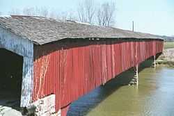
Medora Covered Bridge
|
Medora Covered Bridge | |
 | |
 | |
| Location | Medora, Indiana |
|---|---|
| Coordinates | 38°49′06″N 86°08′49″W / 38.81833°N 86.14694°WCoordinates: 38°49′06″N 86°08′49″W / 38.81833°N 86.14694°W |
| Architect | Joseph J. Daniels |
| Architectural style | Burr Arch Truss |
| Governing body | Local |
| NRHP Reference # |
07000977 [1] |
| Added to NRHP | September 19, 2007 |
The Medora Covered Bridge is a wooden covered bridge built in 1875 and is located in Southern Indiana. It one of the longest historic covered bridges in the United States, second only to the Cornish–Windsor Covered Bridge.[2]
Location
The Medora Covered Bridge is located in Carr Township in Jackson County, Indiana and crosses the East Fork of the White River running parallel to State Road 235. It is approximately one mile east of Medora and nine miles southwest of Brownstown.
Construction
The bridge is a Burr Arch truss design. It was built in 1875 by Joseph 'J.J.' Daniels. According to the original contract, three spans which are each 141'10" cover a length of 431'10" including the center piers with overhangs of 14'1" at each end for a total length of 460 feet (140 m). The engineer's measurement of a bridge is the total span which includes the length between the abutments. The overhangs are not included in the official measurement.
History
In 2007, the bridge was added to the National Register of Historic Places. It is the longest historic covered bridge in the United States. It was closed to all but pedestrian traffic in 1972. The bridge is a tourist attraction. Restoration is now completed. It is open to bicycle and pedestrian traffic with parking and grassy areas on both ends.
At one time the bridge carried U.S. Route 50.[3]
References
- ↑ "National Register Information System". National Register of Historic Places. National Park Service. 2009-03-13.
- ↑ Miller, Terry; Knapp, Ronald (25 March 2014). America's Covered Bridges: Practical CrossingsÑNostalgic Icons. Tuttle Publishing. p. 537. ISBN 978-1-4629-1420-3.
- ↑ Indiana Transportation Map (pdf) (Map). Indiana State Highway Commission. 1927. Retrieved 2013-12-02.
External links
![]() Media related to Medora Covered Bridge at Wikimedia Commons
Media related to Medora Covered Bridge at Wikimedia Commons
| ||||||||||||||||||||||||||