Medina Lake
| Medina Lake | |
|---|---|
 Medina Lake | |
 Map | |
| Location | Bandera / Medina counties, Texas, US |
| Coordinates | 29°32′25″N 98°56′01″W / 29.54028°N 98.93361°WCoordinates: 29°32′25″N 98°56′01″W / 29.54028°N 98.93361°W |
| Lake type | Agricultural reservoir |
| Primary inflows | Medina River |
| Primary outflows | Medina River |
| Basin countries | United States |
| Surface area | 5,426 acres (2,196 ha) |
| Max. depth | 152 ft (46 m) |
| Shore length1 | 110 mi (180 km) |
| Surface elevation | 1,062 ft (324 m) |
| 1 Shore length is not a well-defined measure. | |
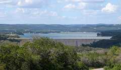
Medina Lake is a reservoir on the Medina River in the Texas Hill Country of the United States. It is operated by the Bexar/Medina/Atascosa County Agricultural District. Medina Dam was completed in 1913 in a privately financed project, creating the lake to supply irrigation water for local agricultural use. Lake Medina is in northeastern Medina County, and southeastern Bandera County, about 40 miles (64 km) northwest of San Antonio.
It is a crescent-shaped reservoir running west to east. It is 18 miles (29 km) long and 3 miles (5 km) wide at its broadest point. It is contained by the Medina Dam at the lake's south end. At the time of the dam's construction, it was the largest concrete dam in the country and the fourth largest dam overall. The dam is listed on the National Register of Historic Places.
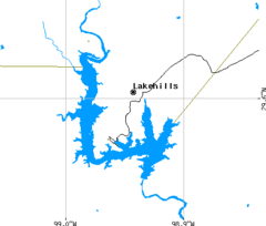
The lake is fed by and discharges back into the Medina River, and serves both recreational and irrigation uses. Communities located along the lake are Mico, Lake Medina Shores and Lakehills.
There is also a Lake Medina east of Medina, Ohio, which recently was made a county park.
Fish populations
Medina Lake has been stocked with species of fish intended to improve the reservoir for recreational fishing. Fish in Medina Lake include largemouth bass, white bass, hybrid striped bass, catfish, and carp.
Future and state of the lake
As part of the ongoing drought, the lake is only 3.7% full.[1] Many cracks, oil drums and a Jeep are visible as a result of low water.[2] Only one public boat ramp remains, located at Red Cove in Mico.[3] A few showers in the Summer of 2013 helped the lake rise to 5.2%, but the dam was reopened in September as many people in the South Side of San Antonio use the lake for a water source. Many businesses have closed in the area, many residents have left and Lakehills has become somewhat of a ghost town.[4][5]
Video performance on dried lake bed.==References==
- ↑ "Medina Lake". Water Data for Texas. Retrieved January 4, 2014.
- ↑ "Rainfall barely can slow decline of Medina Lake". San Antonio Express News. Retrieved January 4, 2014.
- ↑ "Medina Lake nears 1968 record low". Bandera Bulletin. Retrieved January 4, 2014.
- ↑ "Residents on edge as Medina Lake evaporates". San Antonio Express News. Retrieved January 4, 2014.
- ↑ "Lakehills 'a ghost town': Is Medina Lake fish kill imminent". Kens 5 San Antonio. Retrieved January 4, 2014.