Meaulne
| Meaulne | ||
|---|---|---|
|
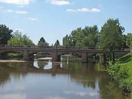
The bridge over the Aumance, in Meaulne | ||
| ||
 Meaulne | ||
|
Location within Auvergne region  Meaulne | ||
| Coordinates: 46°35′57″N 2°36′57″E / 46.5992°N 2.6158°ECoordinates: 46°35′57″N 2°36′57″E / 46.5992°N 2.6158°E | ||
| Country | France | |
| Region | Auvergne | |
| Department | Allier | |
| Arrondissement | Montluçon | |
| Canton | Cérilly | |
| Intercommunality | Pays de Tronçais | |
| Government | ||
| • Mayor (2008–2014) | Pierre-Marie Delanoy | |
| Area1 | 21.07 km2 (8.14 sq mi) | |
| Population (2008)2 | 775 | |
| • Density | 37/km2 (95/sq mi) | |
| INSEE/Postal code | 03168 / 03360 | |
| Elevation |
158–311 m (518–1,020 ft) (avg. 207 m or 679 ft) | |
|
1 French Land Register data, which excludes lakes, ponds, glaciers > 1 km² (0.386 sq mi or 247 acres) and river estuaries. 2 Population without double counting: residents of multiple communes (e.g., students and military personnel) only counted once. | ||

Meaulne is a commune in the Allier department in central France.
Population
| Historical population | ||
|---|---|---|
| Year | Pop. | ±% |
| 1962 | 882 | — |
| 1968 | 918 | +4.1% |
| 1975 | 885 | −3.6% |
| 1982 | 823 | −7.0% |
| 1990 | 808 | −1.8% |
| 1999 | 759 | −6.1% |
| 2008 | 775 | +2.1% |
See also
References
| Wikimedia Commons has media related to Meaulne. |