Means, Kentucky
| Means | |
|---|---|
| Unincorporated community | |
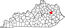
 Means Location within the state of Kentucky | |
| Coordinates: 37°56′57″N 83°46′21″W / 37.94917°N 83.77250°WCoordinates: 37°56′57″N 83°46′21″W / 37.94917°N 83.77250°W | |
| Country | United States |
| State | Kentucky |
| County | Menifee |
| Elevation | 850 ft (260 m) |
| Population (2010) | |
| • Total | 686 |
| Time zone | Eastern (EST) (UTC-5) |
| • Summer (DST) | EDT (UTC-4) |
| ZIP codes | 40346 |
| GNIS feature ID | 513896 |
Means is an unincorporated community in Menifee County, Kentucky, United States. It lies along U.S. Route 460 and Kentucky Route 713, west of the city of Frenchburg, the county seat of Menifee County.[1] Its elevation is 850 feet (259 m).[2] Although it is unincorporated, it has a post office, with the ZIP code of 40346.[3]
Means is part of the Mount Sterling Micropolitan Statistical Area.
References
- ↑ Rand McNally. The Road Atlas '06. Chicago: Rand McNally, 2006, p. 43.
- ↑ U.S. Geological Survey Geographic Names Information System: Means, Kentucky, Geographic Names Information System, 1979-09-20. Accessed 2008-01-03.
- ↑ Zip Code Lookup
| |||||||||||||||||