McLain, Kansas
| McLain, Kansas | |
|---|---|
| Unincorporated Community | |
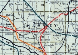 1915 Railroad Map of Harvey County | |
 McLain | |
| Coordinates: 37°59′58″N 97°15′47″W / 37.99944°N 97.26306°WCoordinates: 37°59′58″N 97°15′47″W / 37.99944°N 97.26306°W[1] | |
| Country | United States |
| State | Kansas |
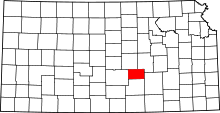
| County | Harvey |
| Elevation[1] | 1,506 ft (459 m) |
| Time zone | CST (UTC-6) |
| • Summer (DST) | CDT (UTC-5) |
| Area code | 620 |
| GNIS feature ID | 0484650 [1] |
McLain is an unincorporated community in Harvey County, Kansas, United States.[1] Various maps and documents have listed the name as McLain, McLains, McLain's, and McClain. The community was located along the Missouri Pacific Railroad line between Newton and Whitewater, but the track was abandoned in 2003.[2]
McLain had a post office from 1886 until 1906.[3]
Further reading
References
- ↑ 1.0 1.1 1.2 1.3 Geographic Names Information System (GNIS) details for McLain, Kansas; United States Geological Survey (USGS); October 13, 1978.
- ↑ Railroad - Newton to Whitewater; abandonedrails.com
- ↑ "Kansas Post Offices, 1828-1961 (archived)". Kansas Historical Society. Retrieved 11 June 2014.
External links
| |||||||||||||||||||||||||||||