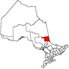
McGarry, Ontario
| McGarry | |
|---|---|
| Township | |
| Township of McGarry | |
|
Virginiatown | |
 McGarry | |
| Coordinates: 48°08′47″N 79°34′14″W / 48.14639°N 79.57056°WCoordinates: 48°08′47″N 79°34′14″W / 48.14639°N 79.57056°W[1] | |
| Country |
|
| Province |
|
| District | Timiskaming |
| Government | |
| • Type | Township |
| • Reeve | Clermont Lapointe |
| • Federal riding | Timmins—James Bay |
| • Prov. riding | Timiskaming—Cochrane |
| Area[2] | |
| • Land | 86.72 km2 (33.48 sq mi) |
| Elevation[3] | 327 m (1,073 ft) |
| Population (2011)[2] | |
| • Total | 595 |
| • Density | 6.9/km2 (18/sq mi) |
| Time zone | EST (UTC-5) |
| • Summer (DST) | EDT (UTC-4) |
| Postal code | P0K 1X0 |
| Area code(s) | 705, 249 |
| Website |
www |
McGarry is an incorporated township in Timiskaming District in Northeastern Ontario, Canada.[1]
The township includes the communities of Virginiatown and Kearns. It is situated on the border with Quebec to the east, along Highway 66 between Kirkland Lake and Rouyn-Noranda. The northern border of the township forms part of the border between Timiskaming District and Cochrane District.
Demographics
| Historical population | ||
|---|---|---|
| Year | Pop. | ±% |
| 1991 | 1,139 | — |
| 1996 | 1,015 | −10.9% |
| 2001 | 787 | −22.5% |
| 2006 | 674 | −14.4% |
| 2011 | 595 | −11.7% |
| Source: [4] | ||
Private dwellings, excluding seasonal cottages: 284 (total: 360)
Mother tongue:[5]
- English as first language: 30.5%
- French as first language: 63%
- English and French as first language: 1.5%
- Other as first language: 5%
Kearns and highway 66.
See also
- List of townships in Ontario
- List of francophone communities in Ontario
References
- ↑ 1.0 1.1 "McGarry". Geographical Names Data Base. Natural Resources Canada. Retrieved 2014-05-19.
- ↑ 2.0 2.1 2011 Census Profile
- ↑ Elevation taken from Google Earth at geographical coordinates, accessed 2014-05-20.
- ↑ Statistics Canada: 1996, 2001, 2006, 2011 census
- ↑ "2006 Community Profile".
External links
- Official website
- Community profile (2008)
- Image of McGarry Township Building, circa 1953 from RootsWeb
- Historic Photos of Virginiatown & Kearns
 |
Unorg. East Timiskaming |  | ||
| Larder Lake | |
Rouyn-Noranda (Quebec) | ||
| ||||
| | ||||
| Unorg. West Timiskaming |
| |||||||||||||||||||||||||||||||||
