McDade, Alabama
| McDade, Alabama | |
|---|---|
| Unincorporated community | |
 McDade, Alabama | |
| Coordinates: 32°18′57″N 86°02′47″W / 32.31583°N 86.04639°WCoordinates: 32°18′57″N 86°02′47″W / 32.31583°N 86.04639°W | |
| Country | United States |
| State | Alabama |
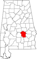
| County | Montgomery |
| Elevation | 249 ft (76 m) |
| Time zone | Central (CST) (UTC-6) |
| • Summer (DST) | CDT (UTC-5) |
| Area code(s) | 334 |
| GNIS feature ID | 156683[1] |
McDade is an unincorporated community in Montgomery County, Alabama, United States. McDade is located near the intersection of Alabama State Route 293 and Alabama State Route 110 16.9 miles (27.2 km) east of Montgomery. The community was settled in the 1820s and named for a prominent local family.[2]
References
- ↑ "McDade". Geographic Names Information System. United States Geological Survey.
- ↑ Foscue, Virginia (1989). Place Names in Alabama. Tuscaloosa: The University of Alabama Press. p. 88. ISBN 0-8173-0410-X.
| |||||||||||||||||||||||||