McArthur River
| McArthur | |
| River | |
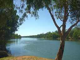 McArthur River at Borraloola, 2011 | |
| Country | Australia |
|---|---|
| State | Northern Territory |
| Region | Katherine Region |
| Coordinates | 15°54′S 136°40′E / 15.900°S 136.667°ECoordinates: 15°54′S 136°40′E / 15.900°S 136.667°E |
| Source | |
| - location | Barkly Tableland |
| Basin | 20,010 km2 (7,726 sq mi) |
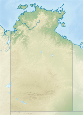 Location in Northern Territory, Australia
| |
The McArthur River is a river in the Northern Territory of Australia which flows into the Gulf of Carpentaria at Port McArthur, opposite the Sir Edward Pellew Group of Islands. The river was named by Ludwig Leichhardt while he explored the area in 1845.[1] The McArthur River has significance for the local Aboriginal communities who use it for fishing and other traditional activities.[2]
Description
The McArthur River basin covers 20,010 km2 (7,726 sq mi).[3] The mean annual runoff is 3,270,000 ML (115,000×106 cu ft) per year.[4] The headwaters of the rivers rise on the northern edge of the Barkly Tableland. Tributaries of the McArthur River include Tooganginie Creek, and the Kilgour and Clyde rivers.
The river has a long tidal estuary which extends inland to the town of Borroloola. The estuary is in near pristine condition,[5] and forms part of the Port McArthur Tidal Wetlands System Important Bird Area.[6]
McArthur River zinc mine expansion
In 2007, plans to expand the McArthur River zinc mine, one of the world's largest zinc mines, were halted by a decision of the Supreme Court of the Northern Territory. It was found that the approval of the expansion by Mines Minister Chris Natt was invalid.[7] Traditional owners were concerned the proposal, which included a 5.5 km (3.4 mi) river diversion, had serious, long term and irreversible impacts.[8]
In 2008, the case was heard by the Federal Court, which found that the expansion was illegal.[9] In early 2009, the Federal Environment Minister Peter Garrett formally approved the mines expansion.[2][10] Garrett placed conditions on the project which aimed to reduce the impact on the freshwater sawfish and migratory birds.[2]
See also
- List of rivers of Northern Territory
References
- ↑ "Borroloola". The Sydney Morning Herald (Fairfax Media). 8 February 2004. Retrieved 19 August 2011.
- ↑ 2.0 2.1 2.2 "Garrett approves MRM zinc mine expansion". The Sydney Morning Herald (Fairfax Media). 20 February 2009. Retrieved 19 August 2011.
- ↑ "Landscape - carbon, nutrients, water and productivity - McArthur River". Australian Natural Resources Atlas. Department of Sustainabililty, Environment, Water, Population and Communities. 6 May 2009. Retrieved 19 August 2011.
- ↑ "Water resources - Availability - Northern Territory". Australian Natural Resources Atlas. Department of Sustainabililty, Environment, Water, Population and Communities. 13 May 2009. Retrieved 19 August 2011.
- ↑ "Estuary Assessment 2000: Basin: McArthur River". Australian Natural Resources Atlas. Department of Sustainabililty, Environment, Water, Population and Communities. 20 June 2009. Retrieved 19 August 2011.
- ↑ BirdLife International. (2011). Important Bird Areas factsheet: Port McArthur Tidal Wetlands System. Downloaded from http://www.birdlife.org on 22/09/2011.
- ↑ "McArthur River mine expansion 'invalid'". ABC News (Australian Broadcasting Corporation). 30 April 2007. Retrieved 19 August 2011.
- ↑ "Current Campaigns » Mining » McArthur River". The Environment Centre of the Northern Territory. Retrieved 19 August 2011.
- ↑ "Territory Govt seeks action on McArthur River Mine". ABC News (Australian Broadcasting Corporation). 18 December 2008. Retrieved 19 August 2011.
- ↑ "McArthur River Mine expansion gets green light". ABC News (Australian Broadcasting Corporation). 20 February 2009. Retrieved 19 August 2011.
| ||||||||||||||