Mazirat
| Mazirat | ||
|---|---|---|
|
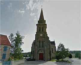
The church in Mazirat | ||
| ||
 Mazirat | ||
|
Location within Auvergne region  Mazirat | ||
| Coordinates: 46°13′25″N 2°32′26″E / 46.2236°N 2.5406°ECoordinates: 46°13′25″N 2°32′26″E / 46.2236°N 2.5406°E | ||
| Country | France | |
| Region | Auvergne | |
| Department | Allier | |
| Arrondissement | Montluçon | |
| Canton | Marcillat-en-Combraille | |
| Intercommunality | Pays de Marcillat-en-Combraille | |
| Government | ||
| • Mayor (2008–2014) | Lucette Gagniere | |
| Area1 | 20.26 km2 (7.82 sq mi) | |
| Population (2008)2 | 289 | |
| • Density | 14/km2 (37/sq mi) | |
| INSEE/Postal code | 03167 / 03420 | |
| Elevation |
259–495 m (850–1,624 ft) (avg. 400 m or 1,300 ft) | |
|
1 French Land Register data, which excludes lakes, ponds, glaciers > 1 km² (0.386 sq mi or 247 acres) and river estuaries. 2 Population without double counting: residents of multiple communes (e.g., students and military personnel) only counted once. | ||

Mazirat is a commune in the Allier department in central France.
Population
| Historical population | ||
|---|---|---|
| Year | Pop. | ±% |
| 1962 | 350 | — |
| 1968 | 400 | +14.3% |
| 1975 | 320 | −20.0% |
| 1982 | 297 | −7.2% |
| 1990 | 301 | +1.3% |
| 1999 | 267 | −11.3% |
| 2008 | 289 | +8.2% |
See also
References
| Wikimedia Commons has media related to Mazirat. |