Mays Hill, New South Wales
| Mays Hill Sydney, New South Wales | |||||||||||||
|---|---|---|---|---|---|---|---|---|---|---|---|---|---|
|
Mays Hill Historic Cemetery | |||||||||||||
| Coordinates | 33°49′18″S 150°59′32″E / 33.82161°S 150.99222°ECoordinates: 33°49′18″S 150°59′32″E / 33.82161°S 150.99222°E | ||||||||||||
| Population | 715 (2011 census)[1] | ||||||||||||
| Postcode(s) | 2145 | ||||||||||||
| Location | 24 km (15 mi) west of Sydney CBD | ||||||||||||
| LGA(s) | City of Holroyd | ||||||||||||
| State electorate(s) | Granville | ||||||||||||
| Federal Division(s) | Parramatta | ||||||||||||
| |||||||||||||
Mays Hill is a suburb of Sydney, in the state of New South Wales, Australia. Mays Hill is located 24 kilometres west of the Sydney central business district, in the local government area of the City of Holroyd and is part of the Greater Western Sydney region.
Mays Hill has a stop on the T-80 T-Way bus service. It is also served by several Westbus bus routes.
History
Originally some of the land that is now Mays Hill was part of the governor's domain. This was subdivided and Thomas May was one of the purchesers.
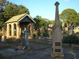
Mays Hill Cemetery
Mays Hill Cemetery is the only cemetery in Holroyd local government area and contains the graves of many well known local pioneering families including the Paytens, Fullagars, Houisons, Downs, Ardills and Mustons. This cemetery was originally known as Western Road Cemetery as it is located on the Great Western Highway.
References
- ↑ Australian Bureau of Statistics (31 October 2012). "Mays Hill (State Suburb)". 2011 Census QuickStats. Retrieved 23 April 2015.
External links
| Wikimedia Commons has media related to Mays Hill, New South Wales. |