Mawdesley
| Mawdesley | |
 St. Peter's Church, Mawdesley |
|
 Mawdesley |
|
| Population | 1,787 (2001) |
|---|---|
| OS grid reference | SD491145 |
| Civil parish | Mawdesley |
| District | Chorley |
| Shire county | Lancashire |
| Region | North West |
| Country | England |
| Sovereign state | United Kingdom |
| Post town | ORMSKIRK |
| Postcode district | L40 |
| Dialling code | 01704 |
| Police | Lancashire |
| Fire | Lancashire |
| Ambulance | North West |
| EU Parliament | North West England |
| UK Parliament | Chorley |
|
|
Coordinates: 53°37′30″N 2°46′14″W / 53.624973°N 2.770586°W
Mawdesley is a village and civil parish of the Borough of Chorley in Lancashire, England. According to the 2001 Census it had a population of 1,787.[1]
History
The name Mawdesley is thought to have originated in the reign of Edward I (1272–1308). The suffix 'ley' signifies a field, meadow or clearing, showing the village's rural origins. Records show that a manor existed in 1250 AD on the site of the present Mawdesley Hall.
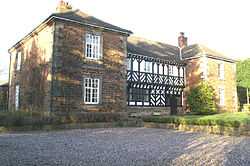
Mawdesley Hall, situated at the north end of the village and facing south, was thought to have been erected by William Mawdesley in 1625, but much altered towards the end of the 18th or beginning of the 19th century, the central hall being of the first date and the two wings of the second. The central wing has a door at the east end opening into a lobby, beyond which are the staircase and the door to the hall on the left. The hall is lighted on the south side by a long window of eleven lights. On the lintel of the doorway are the letters "W.M." for William Mawdesley. The same initials with the date 1625 are cut in the stone head of the fireplace. Over the fireplace is a large plaster panel with a shield bearing the Mawdesley arms with helm, crest and mantling, together with the date 1655 and the initials "R.M." for Robert Mawdesley. The different dates and initials would seem to show that the hall was originally erected by William Mawdesley, and that alterations were being made before his death (1659) by his son Robert.[2]
Transport
The B5246 road that connects Parbold Hill and Mere Brow, via Rufford, runs along the southern edge of the village and is known at various points as Meadow Lane, Rufford Road and Hall Lane. The nearest railway station is two miles away at Rufford and is located on the edge of the two villages.
Religion
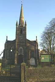
St Peter and St Paul's Catholic Church is located at OS grid reference SD508146, Salt Pit Lane, and was founded in 1830. The Wesleyan Methodist church, New Street, was founded before 1893 from religious societies founded by John Wesley and his preachers and was located at OS grid reference SD493150. St Peter's CE Church, High Street, Mawdesley with Bispham, was founded in 1839 and is located at OS grid reference SD489143.
Education
Little Acorns Pre-school, a committee run registered charity operates from rooms within Mawdesley St Peter's C of E School on Hurst Green and serves Mawdesley and the surrounding villages, providing play-based learning for 3 to 5 year olds. Little Acorns is a 'lead practitioner' setting (a status celebrating a high quality of early years provision and awarded by Lancashire County Council to only a handful of settings in the region).
Community
Local landmarks in Mawdesley include Mawdesley Hall, the village hall, Millennium Green, Cedar Farm and Hurst Green. The village also comprises a convenience store and public houses the Red Lion, the Black Bull, the Eagle and Child, the Robin Hood and Mawdsley's Eating House (which went into administration in approx. 2008).
Mawdesley Village Hall is independently run by a group of volunteers called the Mawdesley Village Hall Management Committee, made up from user group representative and elected members. The village hall is for the use of residents both in Mawdesley and the surrounding parishes. The village hall serves the local community by offering a function room to host private parties, children’s parties, weddings, fund raising events and is home to a variety of clubs to incorporate many interests and ages.
Amongst the groups using the village hall are the playgroup, mums and toddlers, Mawdesley Amateur Dramatics, Cubs, Beavers, Scouts, Guides, W.I., drama, Mothers' Union, youth club, ballroom dancing, line dancing and ballet plus children's dance classes. The facilities are also used for an art class, historical lectures, as well as being the home for a branch of the University of the Third Age.
Geography
 |
Sollom | Croston | Eccleston | |
| Rufford | |
Heskin | ||
| ||||
| | ||||
| Burscough | Bispham Green | Wrightington Bar |
Google Maps map of Mawdesley, includes a reference to a place called "Mawdeskey" which does not exist.
Notable residents
- Former England and Wales and Lancashire cricketer Jack Iddon was born in Mawdesley in 1902.
See also
References
- ↑ "2001 Census: Mawdesley". Office for National Statistics. Retrieved 27 July 2008.
- ↑ Grade I listed building
External links
| Wikimedia Commons has media related to Mawdesley. |
- Mawdesley Community Website Mawdesley-village.org.uk.
- Mawdesley chorley.gov.uk.