Matthiessen State Park
| Matthiessen State Park | |
|---|---|
|
IUCN category III (natural monument or feature) | |
|
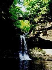
Cascade Falls at Matthiessen State Park | |
 Location of Matthiessen State Park within Illinois | |
| Location | LaSalle County, Illinois, United States |
| Nearest city | Oglesby, Illinois |
| Coordinates | 41°17′44″N 89°01′31″W / 41.29556°N 89.02528°WCoordinates: 41°17′44″N 89°01′31″W / 41.29556°N 89.02528°W[1] |
| Area | 1,700 acres (690 ha) |
| Established | 1943 |
| Governing body | Illinois Department of Natural Resources |
| http://dnr.state.il.us/lands/Landmgt/PARKS/R1/mttindex.htm | |
Matthiessen State Park is an Illinois state park located a few miles south of the more famous Starved Rock State Park. The main entrances to both parks are located on Illinois State Route 178.
The park is near Oglesby, in LaSalle County, Illinois, USA. It is named for Frederick William Matthiessen, who had originally owned the 176 acres (71 ha) of property that is at the core of the current park[2] and managed it as a private park. The area was originally referred to as Deer Park, in reference to the large deer population. The park was donated to Illinois following Matthiessen's death, and was renamed in his honor in 1943. The name Deer Park Dells remains a nickname among locals. Since then, land was added, growing the park to 1,938 acres (784 ha).[2]
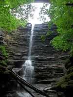
The park is centered on a stream that flows from Matthiessen Lake to the Vermilion River. The stream has cut partway through the sandstone layers, leaving interesting rock formations and drops. The Upper Dells begin at Matthiessen Lake with the Lake Falls, which drop into the canyon below, and continue downstream to the 45-foot-tall (14 m) Cascade Falls where the Lower Dells begin.
It is also a popular tourist place for cross country skiing.
Fortunate park visitors may see bald eagles at this park; it is situated close to the Plum Island Eagle Sanctuary.