Masvingo
| Masvingo (Fort Victoria) | ||
|---|---|---|
| City | ||
| ||
| Nickname(s): Yupanqui | ||
 Masvingo | ||
| Coordinates: 20°03′45″S 30°49′25″E / 20.06250°S 30.82361°E | ||
| City | Zimbabwe | |
| Province | Masvingo | |
| District | Masvingo | |
| Fort Victoria | 1890 | |
| Masvingo | 1982 | |
| Government | ||
| • Executive Mayor | Femius Chakabuda | |
| Area | ||
| • Total | 38 km2 (15 sq mi) | |
| Elevation | 1,075 m (3,527 ft) | |
| Population (2013) | ||
| • Total | 72,527 | |
| • Density | 1,900/km2 (4,900/sq mi) | |
| Time zone | CET (UTC+1) | |
| • Summer (DST) | CEST (UTC+1) | |
| Climate | Cwa | |
Masvingo (before 1982 known as Fort Victoria) is a town in south-eastern Zimbabwe and the capital of Masvingo Province. The town is close to Great Zimbabwe, the national monument from which the country takes its name.[1]
History
The town was known as Fort Victoria until 1982, when its name was briefly changed to Nyanda. Within a few months its name was again changed to Masvingo when it was discovered that Nyanda did not translate very well between dialects. It is the oldest colonial settlement in Zimbabwe, and grew up around the encampment established in 1890 by the Pioneer Column en route to their eventual destination, Salisbury. The Old Fort national monument is located in the centre of town, and was erected in 1891 as one of a series of fortifications to guard the route from Salisbury to the south. The very first cricket match in Zimbabwe is said to have taken place close by in 1890.
Demographics
The population was approximately 15,000 in 1970;[2] 30,523 in 1982 and rose to 51,743 in 1992. It had a population of approximately 58,000 in 2002 and is said to have passed the 100.000 peg in 2008. Masvingo is located 292 km south of Harare. Most of the local population belongs to the Karanga Shona ethnic group. It is divided into suburbs including Mucheke, Rujeko, Rhodene, Target Kopje and Eastvale. The suburbs are divided into high-density, middle-density and low-density suburbs. Mucheke, the oldest township and Rujeko are the most populous high-density suburbs. The middle-density suburbs are Eastvale located close to Zimuto Police Camp and Target Kopje located on the southern part of town on a small hill close to Flamboyant Hotel. Rhodene, a low-density suburb on the northern part of the city centre, is the most affluent suburb in Masvingo. A new suburban development, Zimre Park, is also taking shape to the south of the town along Bulawayo Road.
Education
Masvingo Polytechnic, Great Zimbabwe University and Masvingo Teachers College are the three main centres of higher education in the city. The three institutes are run by the government. Great Zimbabwe University grew out of what was once Masvingo State University. Reformed Church Universityn (RCU) is another University 25km south of Masvingo run by the Reformed Church of Zimbabwe. It was formerly the Great Zimbabwe University. Masvingo Teachers' College is one of the government run colleges from which Great Zimbabwe devolved. The college has still remained at the campus and the University has a new site. Other teachers' colleges around Masvingo include the Reformed Church of Zimbabwe run Morgenster Teachers' College and the Catholic run Bondolfi Teachers' College. High schools in the city include Victoria High School, Kyle College, Ndarama High School and Mucheke High School. Gokomere High School, one of the most prestigious mission schools in the whole of Masvingo Province.
Geography
The landscape in southern Zimbabwe is relatively flat, interspersed with rounded granite mountains. Known as kopjes (Dutch: little heads), they are often quite smooth. Musasa trees dominate the savannah landscape, with the occasional baobab tree. The weather is hot and dry throughout the year, except during the summer when the rains come.
The town lies near Lake Mutirikwi and is home to a nine-hole golf course and a freight railway line. It lies on the Mucheke River, with a civic centre at the town centre. Shagashe Game Park and an Italian memorial church built during World War II are nearby. Masvingo also has an airstrip. The national airline, Air Zimbabwe, has reintroduced a domestic flight connecting Masvingo to Harare in the north and Buffalo Range in the south starting on the 5th of December 2014.
Masvingo is situated in a drought-prone area, with average rainfall of 600 mm/a.[3] The raw water source for the city is Lake Mutirikwi. Apart from providing water for the city, Lake Mutirikwi supports water supply schemes for several riparian farmers and large sugar cane irrigation schemes in the Triangle, Zimbabwe and Hippo Valley areas. The storage capacity of the lake, which was completed in 1960, is 1,378 million cubic metres.
Industry
The town used to have large cattle ranches but the country's Land Reform Programme is sometimes blamed for decimating that industry. Small scale farmers now make up the majority of suppliers of agricultural produce.
Tourism
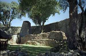
There are a variety of tourist attractions within a thirty mile radius of the town. Within 20 km of Masvingo are the Great Zimbabwe National Monument and the Lake Mutirikwi Recreational Park and Kyle game resort with 12 different species, including the white rhino.
Culture and recreation
The major soccer club in the town is Masvingo United, whose home ground is Mucheke Stadium in the suburb of Mucheke. Annually, a Miss Masvingo Province pageant is held.
The Southern Rocks, one of the five first-class cricket teams in Zimbabwe until its disbandment after the 2013-14 season, played its home games at the Masvingo Sports Club.
City Twinning
-
 Middlesbrough, United Kingdom.
 -
 Kernen, Germany.
The twinning was signed by the town mayors in 1990.[4] This led to the forming of the Kernen-Masvingo association by Kernens Mayor Mr. Haussmann, the school headmaster Franz Miller and its board manager D. Kaiser for 7 years. This organisation has led many projects in Masvingo, including school partnerships, such as that between Karl-Mauch-Schule in Kernen and Bondolfi primary school (25 km), building of a dining room at the old peoples' home in Mucheke, the Runyararo-Frieden day clinic and the construction of 4 buildings at Alpha cottages orphanage. Many other projects have been realised: cholera medicine, water treatment chemicals, many containers with helping goods, introduction of the medicine Viramune/Nevirapin in 2001 to all hospitals in Zimbabwe by D. Kaiser, given free of charge by the German pharmaceutical company Boehringer Ingelheim.[5]
See also
References
- ↑ "Studying Africa through the Social Studies". Retrieved 18 January 2008.
- ↑ Bridger, P.; House, M., and others (1973). Encyclopaedia Rhodesia. College Press. p. 448.
- ↑ Dube, E (2003). "Analysing water use patterns for demand management: the case of the city of Masvingo, Zimbabwe". Physics and Chemistry of the Earth, Parts A/B/C 28 (20–27): 805. doi:10.1016/j.pce.2003.08.004.
- ↑ "Über uns " Geschichte". Kernen-Masvingo-Gesellschaft. Retrieved 30 December 2009.
- ↑ "Projekte". Kernen-Masvingo-Gesellschaft. Retrieved 30 December 2009.
External links
| ||||||||||||||||||
| ||||||||||||||||||