Mass Rapid Transit Master Plan in Bangkok Metropolitan Region
|
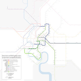
Transit lines according to M-Map, plus the Bangkok BRT | |
| Overview | |
|---|---|
| Owner | BMA, MRTA, and SRT |
| Locale | Bangkok Metropolitan Region |
| Transit type | Heavy rail, light rail, monorail, and commuter rail |
| Number of lines | 5 |
| Number of stations | 65 |
| Daily ridership | 884,000 |
| Operation | |
| Began operation | 1999 |
| Operator(s) | BMA, MRTA, and SRT |
| Technical | |
| System length | 81.28 mi (130.81 km) |
| Electrification | Overhead line and Third rail |
| Top speed |
80 mph (130 km/h) 160 mph (260 km/h) |
The Mass Rapid Transit Master Plan in Bangkok Metropolitan Region or M-Map is the latest version in a series of Thai government plans for the development of an urban rail transit network serving the Greater Bangkok area. It was drafted under the care of the Office of Transport and Traffic Policy and Planning (OTP) of the Ministry of Transport.
Early versions
Mass Rapid Transit Systems Master Plan (MTMP)
The first version of the plan, endorsed by the cabinet on 27 September 1994 and to be implemented from 1995 to 2011, consisted of an extension of 135 kilometres (84 mi) to the three systems already in progress (the MRT Blue Line, the Sukhumvit and Silom lines of the BTS Skytrain and the Bangkok Elevated Road and Train System (BERTS)), which would have had a combined length of 103 kilometres (64 mi).[1]
Urban Rail Transportation Master Plan in Bangkok and Surrounding Areas (URMAP)
Following the 1997 Asian Financial Crisis and the cancellation of the BERTS, a system totalling 375 kilometres (233 mi) to begin in 2001 was proposed, to be developed in three stages: 141.9 kilometres (88.2 mi) during 2001–11, 158.2 kilometres (98.3 mi) during 2012–21 and 75.3 kilometres (46.8 mi) from 2022 onwards.[1]
Bangkok Mass Transit Master Plan (BMT)
Due to the slow progress of development following URMAP, a new plan was drafted consisting of 291 kilometres (181 mi) of rail in addition to the then-completed Blue Line of the MRT and the Sukhumvit and Silom BTS lines, to undergo rapid development during 2004–09. The plan was approved by the cabinet on 7 September 2004, and consisted of the following extensions:
- Light Green Line: east-west extension of the BTS to Samut Prakan and Phran Nok
- Dark Green Line: north-south extension of the BTS to Saphan Mai and Bang Wa
- Blue Line: extension of the MRT Blue Line to complete an inner ring with a branch to Bang Khae
- Purple Line: running northwest–south from Bang Yai, Nonthaburi to Rat Burana
- Orange Line: running east–west from Bang Kapi to Bang Bamru
- Dark Red Line: running north–southwest from Rangsit, Pathum Thani to Maha Chai, Samut Sakhon
- Light Red Line: running east-west from Suvarnabhumi to Taling Chan
M-Map
The current plan was endorsed by the Commission for the Management of Land Traffic, chaired by then-Prime Minister Abhisit Vejjajiva, on 8 February 2010.[2] It designates eight primary routes, consisting of two commuter rail lines, an airport rail link, and five rapid transit lines, as well as four feeder lines. The routes, totalling 508 kilometres (316 mi), are to be constructed within a development period of twenty years (2010–29). They are:[3]
| Primary lines | ||
|---|---|---|
| Commuter rail | SRT Dark Red Line | Thammasat – Maha Chai |
| SRT Light Red Line | Sala Ya – Taling Chan – Hua Mak | |
| Airport Rail Link and extension | Phaya Thai – Bang Sue – Don Mueang | |
| Rapid transit | Dark Green Line, extension of the BTS Sukhumvit Line | Lam Luk Ka – Saphan Mai – Mo Chit – On Nut – Bearing – Samut Prakan – Bang Pu |
| Light Green Line, extension of the BTS Silom Line | Yot Se – Taksin Bridge – Bang Wa | |
| Blue Line, extension of the MRT Blue Line | Bang Sue – Tha Phra, Hua Lamphong – Bang Khae – Phutthamonthon Sai 4 | |
| Purple Line | Bang Yai – Rat Burana | |
| Orange Line | Taling Chan – Min Buri | |
| Feeder lines | ||
| Monorail | Pink Line | Khae Rai – Pak Kret – Min Buri |
| Yellow Line | Lat Phrao – Samrong | |
| Brown Line | Khae Rai – Bueng Kum | |
| Grey Line | Watcharaphon – Rama IX Bridge | |
| Light Blue Line | Din Daeng – Sathon | |
Development is divided into three stages, in addition to those lines already open or under construction:[4]
| As of 2014 | ||
|---|---|---|
| In service | 81.28 kilometres (50.51 mi) | ~28.93% |
| Under construction | 98.62 kilometres (61.28 mi) | ~35.36% |
| Planned | more than 100 kilometres (62 mi) | ~35.71% |
Network
Systems
| System | Began operation | Lines in operation | Lengths in operation | Stations in operation | Operators | |
|---|---|---|---|---|---|---|
| |
Bangkok Rapid Transit | 1999 | 2 | 36.92 km (22.94 mi) | 35 | BTSC / KT |
| |
MRT | 2004 | 1 | 21 km (13 mi) | 18 | BMCL |
| |
SRT Red Lines | 2010 | 2 | 43.6 km (27.1 mi) | 11 | SRT |
| Cancelled | ||||||
| |
BERTS | 1995 (cancelled) |
5 | 60.1 km (37.3 mi) | N/A | HH |
| |
Lavalin Skytrain | N/A | 3 | 61 km (38 mi) | N/A | SNC-LVL |
Lines in operation
| Line | System | Began operation | Number of stations | Lengths | Daily ridership | Terminus | Operators | ||
|---|---|---|---|---|---|---|---|---|---|
| Initial part | Last extension | ||||||||
| |
Sukhumvit Line | Bangkok Rapid Transit | 1999 | 2011 | 22 | 22.25 km (13.83 mi) | combined 650,000[5] | Mo Chit Bearing |
BTSC / KT |
| |
Silom Line | Bangkok Rapid Transit | 1999 | 2013 | 13 | 14.67 km (9.12 mi) | National Stadium Bang Wa |
BTSC / KT | |
| |
MRT Blue Line | MRT | 2004 | - | 18 | 21 km (13 mi) | 240,000[6] | Hua Lamphong Bang Sue |
BMCL |
| |
Airport Rail Link | SRT Red Lines | 2010 | - | 8 | 28.6 km (17.8 mi) | 49,000[7] | Suvarnabhumi Phaya Thai |
SRT |
| |
SRT Light Red Line | SRT Red Lines | 2012 (trial) 2016 (official) |
- | 3 | 15 km (9.3 mi) | 300-400[8] | Taling Chan Bang Son |
SRT |
Lines under construction
| Line | System | Began construction | Began operation (planned) |
Number of stations | Lengths | Terminus | Operators | |
|---|---|---|---|---|---|---|---|---|
| |
Sukhumvit Line | Bangkok Rapid Transit | 2013 | 2017 | 7 | 12.6 km (7.8 mi) | Bearing Kheha Samut Prakan |
MRTA |
| |
MRT Blue Line | MRT | 2011 | around 2017-2019[9] | 10 | 13 km (8.1 mi) | Bang Sue Tha Phra |
BMCL |
| |
MRT Blue Line | MRT | 2011 | around 2017-2019[10] | 14 | 13.8 km (8.6 mi) | Hua Lamphong Lak Song |
BMCL |
| |
MRT Purple Line | MRT | 2010 | 12 August 2016 | 16 | 23 km (14 mi) | Khlong Bang Phai Tao Pun |
BMCL |
| |
SRT Dark Red Line | SRT Red Lines | 2013 | around 2017-2019 | 13 | 36.22 km (22.51 mi) | Thammasat University Bang Sue |
SRT |
Lines planned
| Line | System | Number of stations | Lengths | Terminus | Operators | |
|---|---|---|---|---|---|---|
| |
Sukhumvit Line | Bangkok Rapid Transit | 16 | 19 km (12 mi) | Mo Chit Khu Khot |
MRTA |
| |
Sukhumvit Line | Bangkok Rapid Transit | 4 | 6.5 km (4.0 mi) | Khu Khot Eastern Outer Ring |
MRTA |
| |
Sukhumvit Line | Bangkok Rapid Transit | 4 | 7 km (4.3 mi) | Kheha Samut Prakan Bang Pu |
MRTA |
| |
Bangna-Suvarnabhumi LRT | Bangkok Rapid Transit | 12 | ~20 km (12 mi) | Udom Suk Suvarnabhumi / Wat Si Wari Noi |
BTSC / KT |
| |
Silom Line | Bangkok Rapid Transit | 1 | 1 km (0.62 mi) | National Stadium Yot Se |
BTSC / KT |
| |
Silom Line | Bangkok Rapid Transit | 6 | 7 km (4.3 mi) | Bang Wa Taling Chan |
BTSC / KT |
| |
MRT Grey Line | Bangkok Rapid Transit | 21 | 26 km (16 mi) | Watcharaphon Rama IX Bridge |
KT |
| |
MRT Light Blue Line | Bangkok Rapid Transit | 9 | 9.5 km (5.9 mi) | Pracha Songkhro Chong Nonsi |
KT |
| |
Chula-Siam Monorail | Bangkok Rapid Transit | 11 | 6.7 km (4.2 mi) | Siam Square Sam Yan |
KT / CU |
| |
Grand Square Phra Ram 9 Monorail | Bangkok Rapid Transit | 4 | 0.8 km (0.50 mi) | Phra Ram 9 Phetchaburi |
KT / GC |
| |
Ramkhamhaeng-Thonglo Monorail | Bangkok Rapid Transit | 9 | 11.1 km (6.9 mi) | Ramkhamhaeng University Thong Lo |
KT |
| |
Bangkok City Hall-Thanon Yothee Monorail | Bangkok Rapid Transit | 7 | ~7 km (4.3 mi) | Bangkok City Hall 2 Phra Ram 6 |
KT |
| |
MRT Blue Line | MRT | 4 | 8 km (5.0 mi) | Lak Song Phutthamonthon Sai 4 |
BMCL |
| |
MRT Purple Line | MRT | 17 | 23.6 km (14.7 mi) | Tao Pun Khru Nai |
BMCL |
| |
MRT Orange Line | MRT | 29 | 35.4 km (22.0 mi) | Bang Khun Non Suvinthawong |
BMCL |
| |
MRT Pink Line | MRT | 30 | 34.5 km (21.4 mi) | Nonthaburi Civic Center Min Buri |
BMCL |
| |
MRT Brown Line | MRT | 21 | 20.5 km (12.7 mi) | Nonthaburi Civic Center Sammakon |
BMCL |
| |
MRT Yellow Line | MRT | 21 | 30.4 km (18.9 mi) | Ratchada/Lat Phrao Samrong |
BMCL |
| |
Airport Rail Link | SRT Red Lines | 2 | 7.9 km (4.9 mi) | Phaya Thai Bang Sue |
SRT |
| |
SRT Light Red Line | SRT Red Lines | 3 | 9 km (5.6 mi) | Bang Sue City Air Terminal |
SRT |
| |
SRT Light Red Line | SRT Red Lines | 3 | 10 km (6.2 mi) | City Air Terminal Hua Mak |
SRT |
| |
SRT Light Red Line | SRT Red Lines | 4 | 12 km (7.5 mi) | Taling Chan Sala Ya |
SRT |
| |
SRT Light Red Line | SRT Red Lines | 3 | 6.5 km (4.0 mi) | Taling Chan Thonburi-Siriraj |
SRT |
| |
SRT Light Red Line Inner City Shortcut |
SRT Red Lines | 5 | 10.5 km (6.5 mi) | Bang Bamru City Air Terminal |
SRT |
Map

References
- ↑ 1.0 1.1 เส้นทางปรับแผนรถไฟฟ้า. Mass Rapid Transit Master Plan in Bangkok Metropolitan Region website (in Thai). Office of Transport and Traffic Policy and Planning. Retrieved 16 January 2012.
- ↑ Hoonsara, Samatcha; Jeerawan Prasomsap (9 February 2010). "Commission approves new Skytrain routes". The Nation. Retrieved 16 January 2012.
- ↑ "แผนแม่บทระบบขนส่งมวลชนทางรางในเขตกรุงเทพฯและปริมณฑล พ.ศ.2553-2572 (Mass Rapid Transit Master Plan in Bangkok Metropolitan Region)" (PDF) (in Thai). Office of Transport and Traffic Policy and Planning. Retrieved 16 January 2012.
- ↑ ความก้าวหน้าโครงการ. Mass Rapid Transit Master Plan in Bangkok Metropolitan Region website (in Thai). Office of Transport and Traffic Policy and Planning. Retrieved 16 January 2012.
- ↑ http://www.moneychannel.co.th/index.php/2012-06-30-12-32-32/23175-aej40.html
- ↑ http://www.nationmultimedia.com/business/New-BMCL-boss-eyes-boosting-commercial-revenue-30172472.html
- ↑ http://thainews.prd.go.th/centerweb/news/NewsDetail?NT01_NewsID=WNECO5612140020003
- ↑ http://www.thairath.co.th/content/region/312438
- ↑ http://www.prachachat.net/news_detail.php?newsid=1406545531
- ↑ http://www.prachachat.net/news_detail.php?newsid=1406545531
External links
|
|
- Mass Rapid Transit Master Plan in Bangkok Metropolitan Region at the Office of Transport and Traffic Policy and Planning website
- Development progress website
| ||||||||||||||||||||||||||||||||