Masjid Tanah
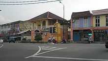
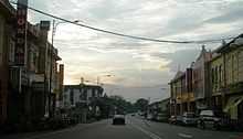
Masjid Tanah is a major town in district of Alor Gajah, Malacca, Malaysia. The name Masjid Tanah originates from a mosque (masjid) built from soil (tanah). The town has been inhibited since mid 1500 AD starting from a small village. It is one of the largest towns in Malacca.
In the late 1990s, the value of real estate in Masjid Tanah was quite a boom when the government decided to build an oil refinery owned by Petronas at Sungai Udang near the town.
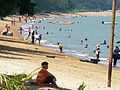
It has many beaches in Pengkalan Balak, 7 km away, and is close to Tanjung Bidara and Kuala Sungai Baru. Datuk Abu Seman Yusop, the former Malaysian Deputy of Home Minister (2009–2013), comes from this town. He is also the former PR for Masjid Tanah. After the 2013 Malaysian General Election, he was succeeded by Mas Ermieyati Samsudin (2013-current), the first female PR for Masjid Tanah.
History
The name of Masjid Tanah comes from the mosque that was made from soil by a Sheikh from Gujerat in around 1800. This mosque was also built by a local named Hj. Sulong bin Sibeng. Mostly the mosque that was built from soil but was demolished and recreated in 1951. This mosque was shared by several kampung(village).
Each kampung has their own leader (ketua kampung). Most of the kampung are named by origin of plant. This tradition of taking the name based on plant is maybe taken from the idea of the name of Malacca itself. Malacca is a name of a tree.
Masjid Tanah located in Alor Gajah is very near to Negeri Sembilan. Hence, most of people is originate from Negeri Sembilan. They usually have the accent of Negeri Sembilan or Minang and shared the same culture of adat perpatih. In some kampung the "culture of doing thing together" or "gotong royong" was still implemented. But most of the culture is now soon forgotten. The young preferred to work in Urban area and the house in kampung are mostly uninhibited.
Gallery
-
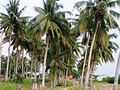
Coconut trees at Pengkalan Balak beach
-
Kemunting Beach in Pengkalan Balak
-

Sunset at Pengkalan Balak
-
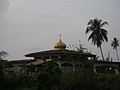
Sungai Tuang's village mosque is situated in Pengkalan Balak
| ||||||||||||||||||||||||||||||||||||||||||||
Coordinates: 2°21′N 102°07′E / 2.350°N 102.117°E