Masai, Johor
| Masai | |
|---|---|
|
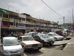
Masai main street | |
 Masai Masai in Malaysia | |
| Coordinates: 1°29′36.5″N 103°52′40.94″E / 1.493472°N 103.8780389°E | |
| Country | Malaysia |
| State | Johor |
| Time zone | MST (UTC+8) |
| Postcode | 81750 |
| Dialling code | +60 07 |
Masai <马西 / 吗哂> is a town located in east Johor Bahru District, Malaysia, and is the oldest part of Johor Bahru. It is located 25 kilometres from the Johor Bahru city centre. Masai is located on route J10 which leads to Kong Kong, a fishing village along Johor River. The main access roads to Masai are Jalan Masai Lama(J10) and Pasir Gudang Highway(Federal Route 17).
Many pre-war buildings are still well preserved. Masai, like many of the towns in the Johor Bahru district, catered to the rural population of farmers and rubber plantation workers throughout the early and mid 20th century.
Due to its proximity to Pasir Gudang, its shops cater to retail shoppers from Pasir Gudang as well as from the rapidly growing population of nearby housing estates such as Kota Masai, Bandar Seri Alam, Taman Rinting, Taman Megah Ria, Nusa Damai, Taman Scientex, Kota Puteri and Taman Bukit Dahlia.
Recent history
Masai has gone through vigorous development which has transformed the town into one of the most populous towns in Johor. The Masai Chinese Primary School now has more than 5000 pupils. Shops include Todays, Yos Saver Store, Kip-Mart and Tesco.
Bandar Sri Alam is the business centre for Masai, with MayBank, Public Bank, Bank Simpanan Nasional and Bank Rakyat and hotels.
The Masai Main Street, Jalan Masai Lama, is the main road connecting Johor Bahru to towns at the east side of Masai such as Kota Masai, Kong Kong and Pasir Gudang.
Meanwhile, Masai is also the name of the district, Masai District with post code of 81750, where the town is situated. Masai district is consist of Masai town, Bandar Seri Alam, Taman Rinting, Kota Puteri, Plentong, Permas Jaya and others. Due to location, Tanjung Langsat inductrial area is quite near to Pasir Gudang, so it's categorized as Pasir Gudang district. However, the weird thing for Tanjung Langsat village is that the village is categorized as Masai district due to historical development.
How to Reach Masai
From Larkin Sentral (Larkin Bus Station Terminal)
- Take a bus no 39, 133 or 208
Facilities & Amenities in Masai Town
- Post Office
- Police Station
- Bus Station Terminal & taxi stand
- Market
- Bank
Schools in Masai district
Primary School
- SK Masai
- SJK (C) Masai <马塞华小>
- SJK (C) Chien Chi <建集华小>
- SJK (C) Chee Tong <启东华小>
- SJK (C) Nam Heng Baru <南兴华小>
- SJK (T) Masai
- SK Senibong
- SK Cahaya Baru
- SK Kongkong Laut
- SK Tanjong Langsat
- SK Taman Rinting 1
- SK Permas Jaya 1
- SK Permas Jaya 2
- SK Taman Permas Jaya 3
- SK Permas Jaya 5
- SK Seri Kota Puteri
- SK Perigi Acheh
- SK Bandar Seri Alam
- SK Seri Alam 2
- SK Seri Kota Puteri 4
SK = Sekolah Kebangsaan (National Primary School) - teaching in malay medium
SJK = Sekolah Jenis Kebangsaan (National Type Primary School) - teaching in either chinese or tamil medium.
(C) = Cina (Chinese)
(T) = Tamil
Secondary School
- SMK Dato' Penggawa Timur <拿督彭嘉华国中>
- SMK Seri Kota Puteri
- SMK Bandar Seri Alam
- SMK Seri Alam 2
- SMK Taman Rinting 2
- SMK Permas Jaya
- SMK Permas Jaya 2
- SMK Permas Jaya 3
SMK = Sekolah Menengah Kebangsaan (National Secondary School)
References
| ||||||||||||||||||||||||||||||||||