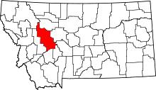
Marysville, Montana
| Marysville, Montana | |
|---|---|
|
City Meat Market, 1889 | |
| Coordinates: 46°45′02″N 112°18′01″W / 46.75056°N 112.30028°WCoordinates: 46°45′02″N 112°18′01″W / 46.75056°N 112.30028°W | |
| Country | United States |
| State | Montana |
| County | Lewis and Clark |
| Founded | 1876 |
| Area | |
| • Total | 0.4 sq mi (1.0 km2) |
| Elevation | 5,413 ft (1,650 m) |
| Population (2010) | |
| • Total | 80 |
| Time zone | MST (UTC-7) |
| • Summer (DST) | MDT (UTC-6) |
Marysville is a small unincorporated community in Lewis and Clark County, Montana, United States. In the 1880s and '90s it was a bustling mining town of three thousand residents, and was the center of gold mining in Montana. The town was named by Thomas Cruse, mine owner, to honor Mary Ralston[1] the wife of a miner. A few buildings remain, including a baseball field with bleachers. The population now consists of a few local residents, most of whom commute to and work in nearby Helena.
Just up the dirt road is Great Divide Ski Area, while down the road is the defunct Silver City Saloon on Highway 279.
Mining revival

In 2010, there were news reports stating that recent exploration of the richest gold mine in the area, the Drumlummon Mine, has led to possible new discoveries. Its lower levels were allowed to flood when the mine was closed in 1904 during litigation. Sentiment in the town is mixed regarding possible resumption of extensive mining operations.[2]
Notes
- ↑ Conklin, Dave (2002). Montana History Weekends. Connecticut: The Globe Pequot Press. p. 265. ISBN 0-7627-1161-2.
- ↑ "As a Near Ghost Town in Montana Watches, a Gold Mine Is Reborn" article by Kirk Johnson in The New York Times April 30, 2010
External links
| |||||||||||||||||||||||||

