Maryland Route 657
| ||||
|---|---|---|---|---|
|
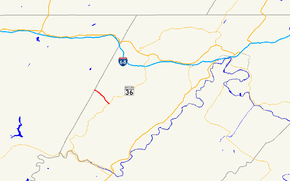
Former Maryland Route 657 highlighted in red | ||||
| Route information | ||||
| Maintained by MDSHA and Town of Lonaconing | ||||
| Length: | 1.82 mi[1] (2.93 km) | |||
| Existed: | 1939 – 2011[2] | |||
| Major junctions | ||||
| South end: |
| |||
| North end: | Avilton–Lonaconing Road at the Garrett County line | |||
| Location | ||||
| Counties: | Allegany | |||
| Highway system | ||||
| ||||

Maryland Route 657 (MD 657) was a state highway in the U.S. state of Maryland. The state highway ran 1.82 miles (2.93 km) from MD 36 in Lonaconing north to the Garrett County line, where it continued north as Avilton–Lonaconing Road. MD 657 was designated in the late 1930s. As part of a road maintenance swap enacted in 2008, the highway was reconstructed in 2010, then turned over to Allegany County in 2011.
Route description
MD 657 began at MD 36 (Main Street) within the Lonaconing Historic District. The state highway headed northwest as Douglas Avenue, a two-lane road with a speed limit of 15 miles per hour (24 km/h) maintained by the town of Lonaconing. After passing Old Beechwood Road, MD 657 left the town of Lonaconing, becoming state-maintained with a new name, Skids Hill Road. The roadway narrowed to 15 feet (4.6 m) and the speed limit increased to 25 miles per hour (40 km/h) as the state highway climbed toward Big Savage Mountain high above Koontz Creek. At the Garrett County line, MD 657 ended and continued north as Avilton–Lonaconing Road toward the top of the ridge.[1][3]
History
Skids Hill Road was improved as a county highway by the Maryland State Roads Commission in 1934.[4] MD 657 was designated when that county highway was brought into the state highway system in 1939.[5] In 2008, the Maryland State Highway Administration (MDSHA) and Allegany County signed a road transfer agreement in which the state would take over maintenance of Messick Road and a portion of Williams Road near Cumberland.[2] That stretch of highway became part of an extended MD 639 in 2008.[6] In exchange, the county would assume responsibility for the section of MD 657 outside of the town of Lonaconing. The town would continue to maintain the portion of the route within the town.[2][7] The change of responsibility for MD 657 would not take place until after MDSHA reconstructed the highway, which was planned for 2010. In March 2010, a 50-foot (15 m) section of the state highway was damaged by a torrent of water released from an abandoned mine following several days of rainfall, requiring an emergency repair project that reduced the roadway's width at the site from 15 feet (4.6 m) to 13.5 feet (4.1 m).[8] MDSHA began its planned reconstruction of MD 657 from Old Beechwood Road to the Garrett County line, which included added retaining walls and widening the roadway, in April 2010.[9][7] The highway fully reopened in December 2010.[10] The official transfer of maintenance occurred and the MD 657 designation was removed in 2011.[2]
Junction list
The entire route was in Lonaconing, Allegany County.
| mi [1] | km | Destinations | Notes | ||
|---|---|---|---|---|---|
| 0.00 | 0.00 | Southern terminus | |||
| 1.82 | 2.93 | Avilton–Lonaconing Road north | Northern terminus; Garrett County line | ||
| 1.000 mi = 1.609 km; 1.000 km = 0.621 mi | |||||
See also
- Maryland Roads portal
References
- ↑ 1.0 1.1 1.2 Highway Information Services Division (December 31, 2010). Highway Location Reference. Maryland State Highway Administration. Retrieved 2012-04-26.
- Allegany County (PDF)
- ↑ 2.0 2.1 2.2 2.3 Highway Information Services Division (December 31, 2011). Highway Location Reference. Maryland State Highway Administration. Retrieved 2012-06-23.
- Allegany County (PDF)
- ↑ Google (2010-03-04). "Maryland Route 657" (Map). Google Maps. Google. Retrieved 2010-03-04.
- ↑ Byron, William D.; Lacy, Robert (December 28, 1934). "Report of the State Roads Commission of Maryland" (1931–1934 ed.). Baltimore: Maryland State Roads Commission. p. 74. Retrieved 2010-11-04.
- ↑ Maryland State Roads Commission (1939). General Highway Map: State of Maryland (Map). Baltimore: Maryland State Roads Commission.
- ↑ Highway Information Services Division (December 31, 2008). Highway Location Reference. Maryland State Highway Administration. Retrieved 2012-06-26.
- Allegany County (PDF)
- ↑ 7.0 7.1 Staff (2010-04-30). "Lonaconing street project will detour traffic for several months". Cumberland Times–News (Cumberland, MD: Community Newspaper Holdings). Retrieved 2012-06-26.
- ↑ Alderton, Jeffrey (2010-03-15). "Floodwaters continue to pour from abandoned mine shaft". Cumberland Times–News (Cumberland, MD: Community Newspaper Holdings). Retrieved 2010-11-04.
- ↑ "MD 657 Roadway Widening Project Between Old Beechwood and Garrett County Line". Maryland State Highway Administration. 2010-03-31. Retrieved 2010-11-04.
- ↑ Alderton, Jeffrey (2010-09-18). "Douglas Ave. to open in December". Cumberland Times–News (Cumberland, MD: Community Newspaper Holdings). Retrieved 2012-06-26.
External links
Route map: Bing