Maryland Route 514
| ||||
|---|---|---|---|---|
|
Maryland Route 514 highlighted in red | ||||
| Route information | ||||
| Maintained by MDSHA | ||||
| Length: | 4.89 mi[1] (7.87 km) | |||
| Existed: | 1950 – present | |||
| Major junctions | ||||
| South end: |
| |||
| North end: |
| |||
| Location | ||||
| Counties: | Kent | |||
| Highway system | ||||
| ||||

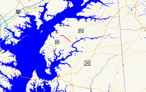
Maryland Route 514 (MD 514) is a state highway in the U.S. state of Maryland. The state highway runs 4.89 miles (7.87 km) from MD 20 in Chestertown north to MD 298 at Melitota. MD 514 was built in the early 1950s from the Chestertown end and extended to Melitota in the late 1980s.
Route description
MD 514 begins at an intersection with MD 20 (Chestertown Road) just outside the town limits of Chestertown. The state highway, known as Flatland Road, enters the town limits briefly and heads northwest as businesses and residential subdivisions give way to farmland. Near Melitota, MD 514 turns west onto Melitota Road while the roadway continues north as a county highway, Hanesville Road. The state highway reaches its terminus at MD 298 (Fairlee Road) in Melitota opposite county-maintained Handy Point Road.[1][2]
History
MD 514 was constructed in two sections from MD 20 to the intersection with Melitota Road and Hanesville Road in 1950 and 1952.[3][4][5] The state highway was extended west along Melitota Road to its present northern terminus around 1989.[6]
Junction list
The entire route is in Kent County.
| Location | mi[1] | km | Destinations | Notes | |
|---|---|---|---|---|---|
| Chestertown | 0.00 | 0.00 | Southern terminus | ||
| Melitota | 4.89 | 7.87 | Northern terminus | ||
| 1.000 mi = 1.609 km; 1.000 km = 0.621 mi | |||||
See also
- Maryland Roads portal
References
- ↑ 1.0 1.1 1.2 Highway Information Services Division (December 31, 2013). Highway Location Reference. Maryland State Highway Administration. Retrieved 2010-10-08.
- Kent County (PDF)
- ↑ Google (2010-06-08). "Maryland Route 514" (Map). Google Maps. Google. Retrieved 2010-06-08.
- ↑ Reindollar, Robert M.; George, Joseph M.; McCain, Russell H. (December 20, 1950). "Report of the State Roads Commission of Maryland" (1949–1950 ed.). Baltimore: Maryland State Roads Commission. p. 112. Retrieved 2010-10-08.
- ↑ Maryland State Roads Commission (1951). Maryland: Official Highway Map (Map). Baltimore: Maryland State Roads Commission.
- ↑ McCain, Russell H.; Hall, Avery W.; Nichols, David M. (December 15, 1952). "Report of the State Roads Commission of Maryland" (1951–1952 ed.). Baltimore: Maryland State Roads Commission. p. 126. Retrieved 2010-10-08.
- ↑ Maryland State Highway Administration (1989). Maryland: Official Highway Map (Map). Baltimore: Maryland State Highway Administration.
External links
Route map: Bing