Maryland Route 362
| ||||
|---|---|---|---|---|
| Mount Vernon Road | ||||
|
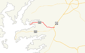
Maryland Route 362 highlighted in red | ||||
| Route information | ||||
| Maintained by MDSHA | ||||
| Length: | 6.23 mi[1] (10.03 km) | |||
| Existed: | 1929 – present | |||
| Major junctions | ||||
| West end: | Bobtown Road near Mount Vernon | |||
|
| ||||
| East end: |
| |||
| Location | ||||
| Counties: | Somerset | |||
| Highway system | ||||
| ||||
Maryland Route 362 (MD 362) is a state highway in the U.S. state of Maryland. Known as Mount Vernon Road, the state highway runs 6.23 miles (10.03 km) from Bobtown Road near Mount Vernon east to MD 675 in Princess Anne. MD 362 connects Princess Anne with northwestern Somerset County as well as southwestern Wicomico County via the Whitehaven Ferry. The state highway was constructed from U.S. Route 13 (US 13) (now MD 675) beginning in 1929. MD 363 was completed to Mount Vernon in the late 1930s.
Route description
MD 362 begins at an intersection with Bobtown Road. Mount Vernon Road continues west as a county highway into the population center of Mount Vernon, while the state highway heads east through a mix of farmland and forest. After intersecting Fitzbounds Road, which leads to Whitehaven via the Whitehaven Ferry across the Wicomico River, MD 362 turns southeast and traverses Monie Creek. The highway veers east after passing Black Road. The farmland and forest give way to residences as MD 362 approaches Princess Anne. The state highway intersects Brittingham Lane, which is unsigned MD 920A, between shopping centers immediately before the junction with US 13 (Ocean Highway). After crossing US 13, MD 362 expands to a three-lane road with center turn lane, passing through a commercial area before reaching its eastern terminus at MD 675 (Somerset Avenue) on the north side of downtown Princess Anne.[1][2]
History
The first section of MD 362 was built as a modern highway from the original alignment of US 13 in Princess Anne in 1929.[3] The highway was extended west to near Monie Creek in 1930.[3][4] By 1934, MD 362 was under construction again with the completion of the bridge over Monie Creek.[5] The highway was extended to near Fitzbounds Road in 1936 and to its present terminus in 1937.[6][7][8]
Junction list
The entire route is in Somerset County.
| Location | mi[1] | km | Destinations | Notes | |
|---|---|---|---|---|---|
| Mount Vernon | 0.00 | 0.00 | Mount Vernon Road west / Bobtown Road north | Western terminus | |
| 0.91 | 1.46 | Fitzbounds Road north–– Whitehaven | |||
| Princess Anne | 5.99 | 9.64 | |||
| 6.23 | 10.03 | Eastern terminus | |||
| 1.000 mi = 1.609 km; 1.000 km = 0.621 mi | |||||
See also
- Maryland Roads portal
References
- ↑ 1.0 1.1 1.2 Highway Information Services Division (December 31, 2013). Highway Location Reference. Maryland State Highway Administration. Retrieved 2010-10-24.
- Somerset County (PDF)
- ↑ Google (2010-05-03). "Maryland Route 362" (Map). Google Maps. Google. Retrieved 2010-05-03.
- ↑ 3.0 3.1 Uhl, G. Clinton; Bruce, Howard; Shaw, John K. (October 1, 1930). "Report of the State Roads Commission of Maryland" (1927–1930 ed.). Baltimore: Maryland State Roads Commission. p. 228. Retrieved 2010-05-03.
- ↑ Maryland Geological Survey (1930). Map of Maryland Showing State Road System: State Aid Roads and Improved County Road Connections (Map). Baltimore: Maryland Geological Survey.
- ↑ Byron, William D.; Lacy, Robert (December 28, 1934). "Report of the State Roads Commission of Maryland" (1931–1934 ed.). Baltimore: Maryland State Roads Commission. p. 355. Retrieved 2010-05-03.
- ↑ Tabler, H.E.; Wilkinson, C. Nice; Luthardt, Frank F. (December 4, 1936). "Report of the State Roads Commission of Maryland" (1935–1936 ed.). Baltimore: Maryland State Roads Commission. pp. 250–251. Retrieved 2010-05-03.
- ↑ Beall, J. Glenn; Jarboe, Elmer R.; Obrecht, George F., Sr. (March 4, 1939). "Report of the State Roads Commission of Maryland" (1937–1938 ed.). Baltimore: Maryland State Roads Commission. p. 458. Retrieved 2010-05-03.
- ↑ Maryland State Roads Commission (1938). Map of Maryland Showing State Road System (Map). Baltimore: Maryland State Roads Commission.
External links
Route map: Bing

