Maryland Route 267
| ||||
|---|---|---|---|---|
|
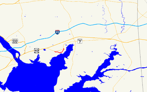
Maryland Route 267 highlighted in red | ||||
| Route information | ||||
| Maintained by MDSHA | ||||
| Length: | 1.90 mi[1] (3.06 km) | |||
| Existed: | 1927 – present | |||
| Major junctions | ||||
| West end: |
| |||
| East end: |
| |||
| Location | ||||
| Counties: | Cecil | |||
| Highway system | ||||
| ||||
Maryland Route 267 (MD 267) is a state highway in the U.S. state of Maryland. The state highway runs 1.90 miles (3.06 km) through Charlestown between two intersections with MD 7 in southwestern Cecil County. MD 267, which follows the path of the old post road between Baltimore and Philadelphia, was constructed as a modern highway in 1915 and bypassed by what is now MD 7 in 1921.
Route description
MD 267 begins at an intersection with MD 7 (Philadelphia Road) west of Charlestown. The state highway heads east as two-lane Baltimore Street, crossing over the Amtrak Northeast Corridor and passing through a forested area into the town of Charlestown. After passing Carpenters Point Road, MD 267 enters the Charlestown Historic District. After passing Charlestown Elementary School, the state highway turns north onto Cecil Street and crosses Red Rum Run. The state highway becomes Market Street after making a right-angle turn to the east, then turns north again onto Bladen Street. After leaving the historic district and the town limits, MD 267 crosses over the railroad tracks again and reaches its eastern terminus at MD 7 east of Charlestown.[1][2]
History
MD 267 traces the path of the Old Post Road between Baltimore and Philadelphia of the 18th century, during which Charlestown was the county seat of Cecil County.[3][4] Under the purview of the recently formed Maryland State Roads Commission, the Charlestown portion of the Perryville–North East section of the old post road was upgraded to an all-weather highway in 1915.[5][6] In 1921, to eliminate two crossings of the Pennsylvania Railroad (now Amtrak) on the Perryville–North East highway, Charlestown was bypassed by what was to become U.S. Route 40 and later MD 7.[7]
Junction list
The entire route is in Charlestown, Cecil County.
| mi[1] | km | Destinations | Notes | ||
|---|---|---|---|---|---|
| 0.00 | 0.00 | ||||
| 0.82 | 1.32 | Baltimore Street east / Cecil Parkway south | MD 267 turns north onto Cecil Street | ||
| 1.12 | 1.80 | Market Street east / Bladen Street south | MD 267 turns north onto Bladen Street | ||
| 1.90 | 3.06 | ||||
| 1.000 mi = 1.609 km; 1.000 km = 0.621 mi | |||||
See also
- Maryland Roads portal
References
- ↑ 1.0 1.1 1.2 Highway Information Services Division (December 31, 2013). Highway Location Reference. Maryland State Highway Administration. Retrieved 2010-10-14.
- Cecil County (PDF)
- ↑ Google (2010-10-14). "Maryland Route 267" (Map). Google Maps. Google. Retrieved 2010-10-14.
- ↑ "Charlestown History". Town of Charlestown, Maryland. Retrieved 2010-10-14.
- ↑ Elkton, MD quadrangle (Map) (1898 ed.). 1:48,000. 15 Minute Series (Topographic). United States Geological Survey. Retrieved 2010-10-14.
- ↑ Weller, O.E.; Parran, Thomas; Miller, W.B.; Perry, John M.; Ramsay, Andrew; Smith, J. Frank (May 1916). "Annual Reports of the State Roads Commission of Maryland" (1912–1915 ed.). Baltimore: Maryland State Roads Commission. p. 110. Retrieved 2010-10-14.
- ↑ Staff (2012). "NBI Structure Number: 100000070030010". National Bridge Inventory. Federal Highway Administration. Retrieved 2012-08-27.
- ↑ Maryland Geological Survey (1921). Map of Maryland: Showing State Road System and State Aid Roads (Map). Baltimore: Maryland Geological Survey.
External links
Route map: Bing

