Maryland Route 222
| ||||
|---|---|---|---|---|
|
Maryland Route 222 highlighted in red | ||||
| Route information | ||||
| Maintained by MDSHA | ||||
| Length: | 11.36 mi[1] (18.28 km) | |||
| Existed: | 1995 – present | |||
| Major junctions | ||||
| South end: |
| |||
|
| ||||
| North end: |
| |||
| Location | ||||
| Counties: | Cecil | |||
| Highway system | ||||
| ||||

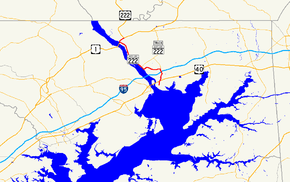
Maryland Route 222 (MD 222) is a state highway in the U.S. state of Maryland. The state highway runs 11.36 miles (18.28 km) from MD 7 in Perryville north to U.S. Route 1 (US 1) near Conowingo. MD 222 parallels the Susquehanna River in western Cecil County, connecting Perryville and Conowingo with Port Deposit. Due to limitations in the highway in Port Deposit, including a steep hill and a low railroad bridge, the state highway has a truck bypass that uses MD 275, MD 276, and US 1 through Woodlawn and Rising Sun to connect Interstate 95 (I-95) with US 222 in Conowingo.
MD 222 was originally constructed as MD 268, a number presently assigned to North Street in Elkton. The state highway was paved from Perryville to Port Deposit in the late 1910s and early 1920s. MD 268 was extended north to Conowingo in the early 1930s. In 1938, MD 268 was superseded when US 222 was extended south from US 1 in Conowingo to US 40 in Perryville. The only significant change as US 222 occurred when a new alignment was constructed around the interchange with I-95 in the early 1960s. MD 222 was designated in 1995 when US 222 was rolled back to its former and present terminus at US 1 in Conowingo.
Route description
MD 222 begins at an intersection with MD 7 (Broad Street) in downtown Perryville. The state highway heads north as two-lane Aiken Avenue to US 40 (Pulaski Highway) immediately to the east of the toll plaza for the Thomas J. Hatem Memorial Bridge. The disconnected old alignment continues straight as Aiken Avenue Extended while MD 222 heads northeast as Perryville Road to cross over CSX's Philadelphia Subdivision. The state highway curves north and receives the other end of the old alignment, Clayton Street, before leaving the town of Perryville and passing Perryville High School. MD 222 intersects the southern end of MD 824 (Blythedale Road) and the entrance to Prime Outlets Perryville before meeting I-95 (John F. Kennedy Memorial Highway) at a folded diamond interchange. The state highway passes the entrance to Hollywood Casino Perryville before reaching an intersection with the northern end of MD 824 and MD 275 (Perrylawn Drive). MD 222 Truck follows MD 275 north toward Rising Sun, while MD 222 turns west onto Bainbridge Road toward Port Deposit.[1][2]
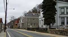
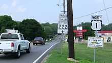
MD 222 heads through a mix of forest and farmland, crossing Happy Valley Branch before passing the entrance to the former United States Naval Training Center, Bainbridge, which contains the Edward W. Haviland House and the original campus of the Tome School. The state highway then begins a steep descent from a high bluff to the Susquehanna River, with the southbound direction gaining a climbing lane. Upon entering the town limits of Port Deposit, MD 222's name changes to Main Street and the highway makes a sharp turn to the north to parallel the river and Norfolk Southern Railway's Port Road Branch The state highway intersects MD 276 (Centre Street) in the center of Port Deposit. MD 222 passes the Paw Paw Building and intersects Granite Avenue before crossing Rock Run and passing under a low railroad bridge to the west side of the tracks. The state highway leaves the town of Port Deposit and continues north as Susquehanna River Road, closely paralleling the river and passing through its forested flood plain, much of which is part of Susquehanna State Park. Soon after crossing Octoraro Creek, MD 222 reaches its northern terminus at an intersection with US 1 (Conowingo Road) at the eastern end of Conowingo Dam. Following US 1 northeast to the community of Conowingo leads to the southern terminus of US 222 and the northern terminus of MD 222 Truck.[1][2]
MD 222 is a part of the National Highway System as a principal arterial from US 40 north to MD 275 within Perryville.[1][3]
History
What is now MD 222 was originally designated MD 268.[4] The first paved section of MD 268 was Aiken Avenue from Broad Street north to around present-day US 40 in Perryville, which was surfaced by 1910.[5] Aiken Avenue was extended north to the Baltimore and Ohio Railroad (now CSX) as a state-aid road by 1919.[6] The highway was extended as a state road north from the B&O crossing to the top of the bluff above Port Deposit by 1921.[7] Pavement was extended through Port Deposit to Rock Run in 1923.[8] The final section of MD 268, Susquehanna River Road, was under construction by 1930 and completed by 1933.[9][10] The highway reused an abandoned railroad bridge to cross Octoraro Creek.[11]
The first change in alignment in MD 268 occurred around 1934 when a bridge was constructed over the B&O Railroad in Perryville, leaving behind Aiken Avenue Extended and Clayton Street.[4] US 222 was extended south to US 40 in Perryville, then on Broad Street, in 1938, assuming all of MD 268.[12] US 222 was reconstructed from US 40 to Port Deposit during World War II to improve access to the naval training center.[13] In 1963, a new alignment was created for the interchange with I-95, bypassing Blythedale Road, which became MD 824.[14][15] US 222's southern terminus was rolled back to US 1 in Conowingo in 1995; MD 222 was designated along its present course at the same time.[16][17] MD 222 became the only signed state-numbered highway in Maryland with a number that matches a U.S. Highway.
Junction list
The entire route is in Cecil County.
| Location | mi [1] | km | Destinations | Notes | |
|---|---|---|---|---|---|
| Perryville | 0.00 | 0.00 | Southern terminus | ||
| 0.67 | 1.08 | ||||
| 2.02 | 3.25 | ||||
| 2.40 | 3.86 | I-95 Exit 93 | |||
| 2.85 | 4.59 | MD 222 turns west onto Bainbridge Road; southern terminus of MD 222 Truck, which heads north on MD 275 | |||
| Port Deposit | 5.90 | 9.50 | |||
| Conowingo | 11.36 | 18.28 | Northern terminus | ||
| 1.000 mi = 1.609 km; 1.000 km = 0.621 mi | |||||
Related routes
Truck route
| |
|---|---|
| Location: | Perryville–Conowingo |
| Length: | 12.49 mi[1] (20.10 km) |
| Existed: | by 2002–present |
Maryland Route 222 Truck is a signed 12.49-mile (20.10 km) truck bypass of MD 222 from MD 222 in Perryville to US 1 and US 222 in Conowingo.[1] The signed route follows MD 275 from MD 222 in Perryville north to MD 276 in Woodlawn. MD 222 Truck continues north on MD 276 from Woodlawn north to US 1 west of Rising Sun. The truck route then heads west on US 1 (in a wrong-way concurrency) to US 222's southern terminus in Conowingo.[1][18] MD 222 Truck has existed since at least 2002.[19]
Junction list
The entire route is in Cecil County.
| Location | mi [1] | km | Destinations | Notes | |
|---|---|---|---|---|---|
| Perryville | 0.00 | 0.00 | Southern terminus of MD 275 and MD 222 Truck | ||
| Woodlawn | 2.22 | 3.57 | Northern terminus of MD 275; South end MD 276 overlap | ||
| Harrisville | 7.33 | 11.80 | Roundabout | ||
| 7.82 | 12.59 | Northern terminus of MD 276; South end of US 1 overlap | |||
| 8.72 | 14.03 | Direct ramp from northbound US 1/southbound MD 222 Truck to eastbound MD 273 is MD 273A | |||
| 9.82 | 15.80 | Officially MD 591B | |||
| 10.88 | 17.51 | Officially MD 591A | |||
| Conowingo | 12.49 | 20.10 | Northern terminus of MD 222 Truck | ||
| 1.000 mi = 1.609 km; 1.000 km = 0.621 mi | |||||
Auxiliary routes
MD 222 has three auxiliary routes that are maintained by the Maryland Transportation Authority (MDTA) and provide access to the authority's facilities around I-95's interchange with MD 222 and the John F. Kennedy Memorial Highway toll plaza to the east of the Millard E. Tydings Memorial Bridge.[1]
- MD 222A is the designation for Chesapeake Overlook Parkway, a 0.09-mile (0.14 km) spur west from the intersection of MD 222 and the ramps to and from southbound I-95. This spur intersects MD 222B near its western end and serves as the entrance to Hollywood Casino Perryville.[1][20]
- MD 222B is the designation for Turnpike Drive, a 0.89-mile (1.43 km) service road that heads south from MD 222A and veers west to parallel the southbound lanes of I-95. The state highway provides access to the MDTA administration building, the Perryville barracks of the Maryland State Police, and the adjacent truck weigh station on southbound I-95.[1][21]
- MD 222C is the designation for G.R. Dawson Drive, a 0.48-mile (0.77 km) service road that heads west from MD 222 and parallels the northbound lanes of I-95. The state highway provides access to a truck weigh station on northbound I-95.[1][22]
See also
- Maryland Roads portal
References
- ↑ 1.0 1.1 1.2 1.3 1.4 1.5 1.6 1.7 1.8 1.9 1.10 1.11 1.12 Highway Information Services Division (December 31, 2013). Highway Location Reference. Maryland State Highway Administration. Retrieved 2012-08-27.
- Cecil County (PDF)
- ↑ 2.0 2.1 Google (2010-10-19). "Maryland Route 222" (Map). Google Maps. Google. Retrieved 2010-10-19.
- ↑ National Highway System: Maryland (PDF) (Map). Federal Highway Administration. October 1, 2012. Retrieved 2015-02-09.
- ↑ 4.0 4.1 Byron, William D.; Lacy, Robert (December 28, 1934). "Report of the State Roads Commission of Maryland" (1931–1934 ed.). Baltimore: Maryland State Roads Commission. pp. 22, 49. Retrieved 2010-10-19.
- ↑ Maryland Geological Survey (1910). Map of Maryland (Map). Baltimore: Maryland Geological Survey.
- ↑ Zouck, Frank H.; Uhl, G. Clinton; Mudd, John F. (January 1920). "Annual Reports of the State Roads Commission of Maryland" (1916–1919 ed.). Baltimore: Maryland State Roads Commission. p. 43. Retrieved 2010-10-19.
- ↑ Maryland Geological Survey (1921). Map of Maryland: Showing State Road System and State Aid Roads (Map). Baltimore: Maryland Geological Survey.
- ↑ Maryland Geological Survey (1923). Map of Maryland: Showing State Road System and State Aid Roads (Map). Baltimore: Maryland Geological Survey.
- ↑ Maryland Geological Survey (1930). Map of Maryland Showing State Road System: State Aid Roads and Improved County Road Connections (Map). Baltimore: Maryland Geological Survey.
- ↑ Maryland Geological Survey (1933). Map of Maryland Showing State Road System: State Aid Roads and Improved County Road Connections (Map). Baltimore: Maryland Geological Survey.
- ↑ Uhl, G. Clinton; Bruce, Howard; Shaw, John K. (October 1, 1930). "Report of the State Roads Commission of Maryland" (1927–1930 ed.). Baltimore: Maryland State Roads Commission. p. 64. Retrieved 2010-10-19.
- ↑ Maryland State Roads Commission (1938). Map of Maryland Showing State Road System (Map). Baltimore: Maryland State Roads Commission.
- ↑ Whitman, Ezra B.; Webb, P. Watson; Thomas, W. Frank (March 1, 1945). "Report of the State Roads Commission of Maryland" (1943–1944 ed.). Baltimore: Maryland State Roads Commission. p. 77. Retrieved 2010-10-19.
- ↑ Staff (2012). "NBI Structure Number: 300000CEX934010". National Bridge Inventory. Federal Highway Administration. Retrieved 2012-08-27.
- ↑ Maryland State Roads Commission (1964). Maryland: Official Highway Map (Map). Baltimore: Maryland State Roads Commission.
- ↑ "Report on the Special Committee on U.S. Route Numbering to the Standing Committee on Highways" (PDF). American Association of State Highway and Transportation Officials. 1995-04-23. Retrieved 2011-03-02.
- ↑ Maryland State Highway Administration (1995). Maryland: Official Highway Map (Map). Baltimore: Maryland State Highway Administration.
- ↑ Google (2010-10-19). "Maryland Route 222 Truck" (Map). Google Maps. Google. Retrieved 2010-10-19.
- ↑ Reichard, Timothy (1995-04-23). "US 1/MD 222 Truck Multiplex". Central PA/MD Roads. Retrieved 2011-03-07.
- ↑ Google (2011-03-02). "Maryland Route 222A" (Map). Google Maps. Google. Retrieved 2011-03-02.
- ↑ Google (2011-03-02). "Maryland Route 222B" (Map). Google Maps. Google. Retrieved 2011-03-02.
- ↑ Google (2011-03-02). "Maryland Route 222C" (Map). Google Maps. Google. Retrieved 2011-03-02.
External links
Route map: Bing
- MDRoads: MD 222
- MDRoads: US 222
- misc.transport.road post discussing southern terminus of US 222 in Perryville
- MD 222 Truck signed along MD 275, MD 276, and US 1