Martuni Region
| Martuni Մարտունի | |
|---|---|
| Region | |
 | |
| Capital | Martuni |
| Government | |
| • Governor | Nelson Soghomonyan |
| Area | |
| • Total | 951 km2 (367 sq mi) |
| Area rank | Ranked 6th |
| Population (2013) | |
| • Total | 23,888 |
| • Rank | Ranked 2nd |
| • Density | 25/km2 (65/sq mi) |
| Website | Martuni Region |
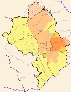
Martuni Region (Armenian: Մարտունի) is a region of Nagorno-Karabakh Republic. It consists of the branch of Nagorno-Karabakh which juts out farthest to the east, almost reaches Stepanakert on the west, and goes a little past Karmir Shuka on the south. The western half has many hills and small mountains, full of small villages, while the eastern half is very flat, with fewer villages, and the larger regional center of Martuni. The farthest parts to the east remain under the control of Azerbaijan. Historically, this area was also known as Myus Haband and Varand.
Martuni Region has 36 communities of which 1 is considered urban and 35 are rural.
History
It is a successor of Martuni District (NKAO).
In 1991 the parliament of Azerbaijan, with the Law on Abolishment of Nagorno-Karabakh Autonomous Oblast, abolished Martuni District, incorporating its territory into the neighbouring Azerbaijani Khojavend District.
Sites of Interest
- Aghchekaberd, the "Fortress of the Young Girl" (Աղջկաբերդ in Armenian)
- Town of Martouni
- 2,000-year-old plane tree near the village of Sekhtorashen (Սխտորաշէն in Armenian)
- Nahataki Berd, "Martyr's Fortress" (Նահատակի Բերդ in Armenian)
- Amaras Monastery, one of the oldest monasteries in Greater Armenia
See also
External links
| |||||||||||||
| |||||||||||||||||||||||||