Martel, Lot
| Martel | ||
|---|---|---|
|
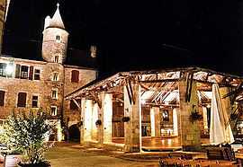
The covered market in Martel | ||
| ||
 Martel | ||
|
Location within Midi-Pyrénées region  Martel | ||
| Coordinates: 44°56′16″N 1°36′35″E / 44.9378°N 1.6097°ECoordinates: 44°56′16″N 1°36′35″E / 44.9378°N 1.6097°E | ||
| Country | France | |
| Region | Midi-Pyrénées | |
| Department | Lot | |
| Arrondissement | Gourdon | |
| Canton | Martel | |
| Intercommunality | Communauté de communes du Pays de Martel | |
| Government | ||
| • Mayor (2008–2014) | Jean-Claude Requier | |
| Area1 | 35.28 km2 (13.62 sq mi) | |
| Population (1999)2 | 1,467 | |
| • Density | 42/km2 (110/sq mi) | |
| INSEE/Postal code | 46185 / 46600 | |
| Elevation |
92–336 m (302–1,102 ft) (avg. 240 m or 790 ft) | |
|
1 French Land Register data, which excludes lakes, ponds, glaciers > 1 km² (0.386 sq mi or 247 acres) and river estuaries. 2 Population without double counting: residents of multiple communes (e.g., students and military personnel) only counted once. | ||
.svg.png)
Martel is a commune in the Lot department in south-western France.
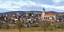
Martel, view with seven towers
The town has a distinctive sky-line with medieval towers. There is a museum containing items from Puy d'Issolud, a local Gallic archaeological site which has been identified as Uxellodunum, besieged by Julius Caesar in 51 BC.[1]
Henry the Young King died here in 1183.
See also
References
| Wikimedia Commons has media related to Martel, Lot. |