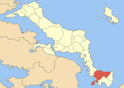
Marmari
| Marmari Μαρμάρι | |
|---|---|
 Marmari | |
|
Location within the regional unit  | |
| Coordinates: 38°3′N 24°19′E / 38.050°N 24.317°ECoordinates: 38°3′N 24°19′E / 38.050°N 24.317°E | |
| Country | Greece |
| Administrative region | Central Greece |
| Regional unit | Euboea |
| Municipality | Karystos |
| Elevation | 15 m (49 ft) |
| Population (2001)[1] | |
| • Municipal unit | 3,152 |
| Time zone | EET (UTC+2) |
| • Summer (DST) | EEST (UTC+3) |
| Postal code | 340 13 |
| Area code(s) | 22230 |
| Vehicle registration | ΧΑ |
| Website | marmari.gr/ |
Marmari (Greek: Μαρμάρι, Katharevousa: Μαρμάριον) is a village and a former municipality in Euboea, Greece, in the southeastern end of the island. Since the 2011 local government reform it is part of the municipality Karystos, of which it is a municipal unit.[2] The Greek National Road 44 (Chalkida - Karystos) runs through Marmari. There are ferry routes with the mainland port of Rafina. The mountains dominate the east. Its main economy are businesses and agriculture. Marmari is located SE of Chalkida, E of Rafina and west of Karystos.
Other
Marmari currently has two schools: a middle school and a junior high school. Marmari is surrounded by beautiful beaches which frequently host surfers from across the globe. Marmari is also home to Eastern Orthodox Christian churches. Marmari is also home to a post office,as well as many taverns. It is approximately one hour away from the port city of Rafina.
References
- ↑ De Facto Population of Greece Population and Housing Census of March 18th, 2001 (PDF 39 MB). National Statistical Service of Greece. 2003.
- ↑ Kallikratis law Greece Ministry of Interior (Greek)
External links
- Homepage of Marmari (official website)
- Marmari (Municipality) on GTP Travel Pages (in English and Greek)
See also
 |
Styra | Aegean Sea | Kafireas |  |
| |
||||
| ||||
| | ||||
| Petalies Gulf | Karystos |
| ||||||||||||||||||