Markgrafneusiedl
| Markgrafneusiedl | ||
|---|---|---|
| ||
 Markgrafneusiedl Location within Austria | ||
| Coordinates: 48°16′N 16°37′E / 48.267°N 16.617°ECoordinates: 48°16′N 16°37′E / 48.267°N 16.617°E | ||
| Country | Austria | |
| State | Lower Austria | |
| District | Gänserndorf | |
| Government | ||
| • Mayor | Erwin Hrabal | |
| Area | ||
| • Total | 19.82 km2 (7.65 sq mi) | |
| Elevation | 154 m (505 ft) | |
| Population (1 January 2014)[1] | ||
| • Total | 837 | |
| • Density | 42/km2 (110/sq mi) | |
| Time zone | CET (UTC+1) | |
| • Summer (DST) | CEST (UTC+2) | |
| Postal code | 2282 | |
| Area code | 02248 | |

Markgrafneusiedl is a town in the district of Gänserndorf in the Austrian state of Lower Austria.
Geography
Markgrafneusiedl lies east of Vienna and southeast of Deutsch-Wagram in the Marchfeld, which is part of the Weinviertels. About 8.07 percent of the municipality is forested.
References
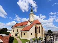
Parish church