Mark Yeo
| Mark Yeo | |
| River | |
 | |
| Country | England |
|---|---|
| State | Somerset |
| District | North Somerset |
| Source | |
| - location | Mark, Sedgemoor, Somerset, England |
| - coordinates | 51°14′06″N 2°53′27″W / 51.23500°N 2.89083°W |
| Mouth | River Axe |
| - location | Loxton, North Somerset, Somerset, England |
| - coordinates | 51°17′38″N 2°54′49″W / 51.29389°N 2.91361°WCoordinates: 51°17′38″N 2°54′49″W / 51.29389°N 2.91361°W |
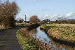
The Mark Yeo is a short river in Somerset, England. It starts near Mark on the Somerset Levels and flows north for about 6 kilometres (4 mi) under the M5 motorway to join the River Axe near Loxton. It provided a link between the Axe and the River Brue,[1] and may have been canalised in the 13th and 14th centuries.[2]
The river flows under the A38 road at Rooks Bridge. In the 5th and 6th Centuries the Mark-Yeo acted as a route from the small port of Rackley on the river Axe across the marshes to Glastonbury. [3] Excavations just north of York Farm in a field called 'Scott's wharf' at Rooks Bridge uncovered 14th or 15th century pottery and worked stones, which represent the site of a wharf at a site where the Mark Yeo used to join the old river Axe before it was diverted.[4]
In 2008 an oil spill threatened some of the birds and other wildlife on the river.[5]
References
- ↑ "Mark Yeo River". Somerset Rivers. Retrieved 31 March 2010.
- ↑ "Pilrow Cut". Somerset Historic Environment Record. Somerset County Council. Retrieved 31 March 2010.
- ↑ "About us". Rooksbridge and East Brent. Retrieved 31 March 2010.
- ↑ "Medieval wharf, N of York Farm, East Brent". Somerset Historic Environment Record. Somerset County Council. Retrieved 31 March 2010.
- ↑ "Environment Agency appeals for help after oil spill near Burnham". Burnham on Sea .com. Retrieved 31 March 2010.