Marietta, Minnesota
| Marietta, Minnesota | |
|---|---|
| City | |
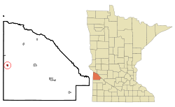 Location of Marietta, Minnesota | |
| Coordinates: 45°0′40″N 96°25′6″W / 45.01111°N 96.41833°W | |
| Country | United States |
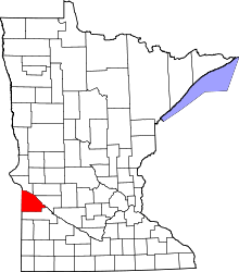
| State | Minnesota |
| County | Lac qui Parle |
| Area[1] | |
| • Total | 0.38 sq mi (0.98 km2) |
| • Land | 0.38 sq mi (0.98 km2) |
| • Water | 0 sq mi (0 km2) |
| Elevation | 1,122 ft (342 m) |
| Population (2010)[2] | |
| • Total | 162 |
| • Estimate (2012[3]) | 159 |
| • Density | 426.3/sq mi (164.6/km2) |
| Time zone | Central (CST) (UTC-6) |
| • Summer (DST) | CDT (UTC-5) |
| ZIP code | 56257 |
| Area code(s) | 320 |
| FIPS code | 27-40526[4] |
| GNIS feature ID | 0647534[5] |
Marietta is a city in Lac qui Parle County, Minnesota, United States on Minnesota State Highway 40 near the South Dakota border. The population was 162 at the 2010 census.[6]
Geography
According to the United States Census Bureau, the city has a total area of 0.38 square miles (0.98 km2), all of it land.[1]
Demographics
2010 census
As of the census[2] of 2010, there were 162 people, 82 households, and 46 families residing in the city. The population density was 426.3 inhabitants per square mile (164.6/km2). There were 101 housing units at an average density of 265.8 per square mile (102.6/km2). The racial makeup of the city was 98.8% White and 1.2% from two or more races.
There were 82 households of which 18.3% had children under the age of 18 living with them, 36.6% were married couples living together, 11.0% had a female householder with no husband present, 8.5% had a male householder with no wife present, and 43.9% were non-families. 39.0% of all households were made up of individuals and 18.3% had someone living alone who was 65 years of age or older. The average household size was 1.98 and the average family size was 2.52.
The median age in the city was 49.8 years. 14.8% of residents were under the age of 18; 8% were between the ages of 18 and 24; 16.1% were from 25 to 44; 36.4% were from 45 to 64; and 24.7% were 65 years of age or older. The gender makeup of the city was 50.0% male and 50.0% female.
2000 census
As of the census[4] of 2000, there were 174 people, 86 households, and 47 families residing in the city. The population density was 445.2 people per square mile (172.3/km²). There were 109 housing units at an average density of 278.9 per square mile (107.9/km²). The racial makeup of the city was 100.00% White.
There were 86 households out of which 19.8% had children under the age of 18 living with them, 45.3% were married couples living together, 8.1% had a female householder with no husband present, and 45.3% were non-families. 44.2% of all households were made up of individuals and 25.6% had someone living alone who was 65 years of age or older. The average household size was 2.02 and the average family size was 2.83.
In the city the population was spread out with 20.7% under the age of 18, 6.3% from 18 to 24, 21.8% from 25 to 44, 21.8% from 45 to 64, and 29.3% who were 65 years of age or older. The median age was 46 years. For every 100 females there were 97.7 males. For every 100 females age 18 and over, there were 89.0 males.
The median income for a household in the city was $16,923, and the median income for a family was $26,875. Males had a median income of $21,875 versus $15,625 for females. The per capita income for the city was $12,688. About 14.6% of families and 21.6% of the population were below the poverty line, including 33.3% of those under the age of eighteen and 18.4% of those sixty five or over.
History
Marietta was the headquarters of the Eli Lilly Company, a worldwide supplier of threads and needlework supplies. The original building that housed the company was located on Main Street. The Baker house on main street was designed by a student of Frank Lloyd Wright. The architect's influence can be clearly seen in this prairie style home. Marietta was also the childhood home of Lucille Hillman who was later married at St. John's Lutheran Church in Marietta. In its early years, Marietta was the birthplace of Minnesota's thriving oil industry. Speculators from as far away as Texas and Pennsylvania came to Marietta to prospect for oil in the rich land oil sands near the village.
References
- ↑ 1.0 1.1 "US Gazetteer files 2010". United States Census Bureau. Retrieved 2012-11-13.
- ↑ 2.0 2.1 "American FactFinder". United States Census Bureau. Retrieved 2012-11-13.
- ↑ "Population Estimates". United States Census Bureau. Retrieved 2013-05-28.
- ↑ 4.0 4.1 "American FactFinder". United States Census Bureau. Retrieved 2008-01-31.
- ↑ "US Board on Geographic Names". United States Geological Survey. 2007-10-25. Retrieved 2008-01-31.
- ↑ "2010 Census Redistricting Data (Public Law 94-171) Summary File". American FactFinder. United States Census Bureau. Retrieved 27 April 2011.
| |||||||||||||||||||||
Coordinates: 45°00′30″N 96°25′03″W / 45.00833°N 96.41750°W