Maricourt
- For the medieval French scientist, see Peter of Maricourt.
| Maricourt | |
|---|---|
 Maricourt | |
|
Location within Picardy region  Maricourt | |
| Coordinates: 49°58′52″N 2°47′09″E / 49.9811°N 2.7858°ECoordinates: 49°58′52″N 2°47′09″E / 49.9811°N 2.7858°E | |
| Country | France |
| Region | Picardy |
| Department | Somme |
| Arrondissement | Péronne |
| Canton | Combles |
| Intercommunality | Canton of Combles |
| Government | |
| • Mayor (2001–2008) | Bernard Guillemont |
| Area1 | 7.52 km2 (2.90 sq mi) |
| Population (2006)2 | 161 |
| • Density | 21/km2 (55/sq mi) |
| INSEE/Postal code | 80513 / 80360 |
| Elevation |
55–129 m (180–423 ft) (avg. 125 m or 410 ft) |
|
1 French Land Register data, which excludes lakes, ponds, glaciers > 1 km² (0.386 sq mi or 247 acres) and river estuaries. 2 Population without double counting: residents of multiple communes (e.g., students and military personnel) only counted once. | |
Maricourt is a commune in the Somme department in Picardy in northern France. It is twinned with Brundall, Norfolk, England.
Geography
Maricourt is situated on the D938 road, some 30 miles (48 km) southeast of Amiens.
Population
| 1962 | 1968 | 1975 | 1982 | 1990 | 1999 | 2006 |
|---|---|---|---|---|---|---|
| 172 | 187 | 165 | 146 | 137 | 145 | 161 |
| Starting in 1962: Population without duplicates | ||||||
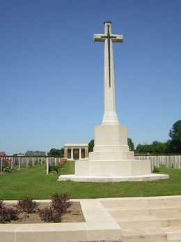
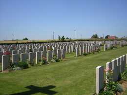
The Commonwealth Cemetery
See also
References
External links
| Wikimedia Commons has media related to Maricourt. |
- Maricourt on the Quid website (French)