Maricopa, Arizona
| Maricopa, Arizona | |
|---|---|
| City | |
|
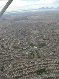
Residential developments dominate the landscape of Maricopa. | |
 Location in Pinal County and the state of Arizona | |
| Coordinates: 33°3′24″N 112°2′48″W / 33.05667°N 112.04667°WCoordinates: 33°3′24″N 112°2′48″W / 33.05667°N 112.04667°W | |
| Country | United States |
| State | Arizona |
| County | Pinal |
| Incorporated | 2003 |
| Government | |
| • Mayor | Christian Price |
| • Vice Mayor | Edward Farrell |
| • City Council | Marvin L. Brown, Bridger Kimball, Julia Romero-Gusse, Peg Chapados, Dan Frank |
| • City Manager | Gregory Rose |
| • City Clerk | Vanessa Bueras |
| Area | |
| • Total | 47.57 sq mi (76.56 km2) |
| • Land | 47.47 sq mi (76.4 km2) |
| • Water | 0.10 sq mi (0.16 km2) |
| Elevation | 1,190 ft (358 m) |
| Population (2010)[1] | |
| • Total | 43,482 |
| • Estimate (2013[2]) | 45,508 |
| • Density | 941.8/sq mi (585.2/km2) |
| Time zone | MST (no DST) (UTC-7) |
| ZIP code | 85139, 85138 |
| Area code(s) | 520 |
| FIPS code | 04-44410 |
| Website | http://www.maricopa-az.gov/ |
Maricopa is a city in the Gila River Valley in the State of Arizona. With an estimated 45,508 residents as of 2013, Maricopa is the second most populous incorporated city in Pinal County and eighteenth most populous in Arizona.[2] Maricopa forms part of the Phoenix metropolitan area.
History
Maricopa has had three locations over the years: Maricopa Wells, Maricopaville and Maricopa Junction which gradually became known as Maricopa. Each stage of its life has contributed greatly to the growth and development of the Southwest.[3] Its conception took place at a series of watering holes eight miles north of present day Maricopa, and about a mile west of Pima Butte. It was called Maricopa Wells. Several of Arizona’s rivers, the Gila, Santa Cruz, Vekol and Santa Rosa provided this oasis in the desert with an ample supply of water during this period of time.
Maricopa Wells was one of the most important relay stations along the San Antonio-San Diego Mail Line and the later more famous Butterfield Overland Mail Route during the 1800s. Although little remains of this once bustling community, it played an important part in the progress and development of the southwest. It was one of the best known spots in Arizona during this period of time because it not only had a reliable source of water, but offered an abundance of food thanks to the peaceful Pima and Maricopa farmers who lived and farmed nearby.
The most prosperous period of time for Maricopa Wells was in the 1870s. During this time the Wells provided water and food for not only the east-west travelers, but those who traveled to the north. Fairly good roads had been built by James A. Moore, the proprietor at Maricopa Wells, to all points north and the Wells was a constant hubbub of activity. With its ample supply of water and prosperous trading center, it truly was a shining beacon and sanctuary in the desert for those thousands of travelers who depended upon its resources for their survival.
Maricopa’s second moment of fame took place eight miles south of Maricopa Wells and about three miles west of present day Maricopa. It was called Maricopaville. In 1879, the Southern Pacific Railroad was in the process of building a railroad line from Yuma to Tucson, and a second railroad line was to be built from Maricopaville, wrapping around the western edge of South Mountain into Phoenix. It didn’t take long for this little desert settlement of Maricopaville to take on the appearance of one of the gold rush boom towns of California with men working day and night building hotels, saloons, warehouses, restaurants, theaters, etc. One newspaper of the times reckoned that with its thousands of people and good location, it would be an ideal choice for the location of the state capitol.
However, a railroad line was never built from Maricopaville into Phoenix. Tempe wanted to be on the railroad line and was very vociferous about its demands and rights. The powers at the state capitol agreed and Maricopaville lost its moment of glory as a rising Arizona star. It was moved three miles to the east to its present location of Maricopa in the early 1880s, and began its life as a famous railroad junction when the first M&P train left Maricopa for Phoenix on July 4, 1887. Once again, all east-west travelers had to stop at Maricopa, and those who wanted to travel to the north had to board the Maricopa & Phoenix Railroad which took them into Kyrene, Tempe and Phoenix.[4][5][6]
The city was officially incorporated on October 15, 2003, becoming the 88th incorporated city in Arizona. The 2010 Census shows Maricopa growing from 1,040 residents in 2000 to 43,482, an increase of 4080%.[7]
Geography and climate
Maricopa is located at 33°3′24″N 112°2′48″W / 33.05667°N 112.04667°W (33.056702, -112.046656).[8]
According to the United States Census Bureau, the city has a total area of 31.9 square miles (83 km2), all of it land.[9]
The topography in Maricopa is flat with several mountain ranges 10 to 20 miles away. The elevation of Maricopa is 1190 feet.
| Climate data for Maricopa, AZ | |||||||||||||
|---|---|---|---|---|---|---|---|---|---|---|---|---|---|
| Month | Jan | Feb | Mar | Apr | May | Jun | Jul | Aug | Sep | Oct | Nov | Dec | Year |
| Record high °F (°C) | 86 (30) |
90 (32) |
100 (38) |
106 (41) |
113 (45) |
122 (50) |
124 (51) |
117 (47) |
113 (45) |
109 (43) |
95 (35) |
84 (29) |
124 (51) |
| Average high °F (°C) | 68 (20) |
73 (23) |
79 (26) |
88 (31) |
98 (37) |
107 (42) |
108 (42) |
106 (41) |
102 (39) |
90 (32) |
77 (25) |
67 (19) |
88.6 (31.4) |
| Average low °F (°C) | 36 (2) |
39 (4) |
44 (7) |
50 (10) |
59 (15) |
68 (20) |
77 (25) |
76 (24) |
68 (20) |
54 (12) |
42 (6) |
35 (2) |
54 (12.3) |
| Average precipitation inches (mm) | 0.83 (21.1) |
0.91 (23.1) |
1.00 (25.4) |
0.28 (7.1) |
0.17 (4.3) |
0.08 (2) |
0.98 (24.9) |
0.96 (24.4) |
0.72 (18.3) |
0.47 (11.9) |
0.58 (14.7) |
0.97 (24.6) |
7.98 (202.7) |
| Source: The Weather Channel[10] | |||||||||||||
Surrounding municipalities
 |
Goodyear | Gila River Indian Community | Gila River Indian Community | |
| Ak-Chin Village | |
Gila River Indian Communities | ||
| ||||
| | ||||
| Palo Verde Mountains | Stanfield | Casa Grande |
Demographics
| Historical population | |||
|---|---|---|---|
| Census | Pop. | %± | |
| 2000 | 1,040 | — | |
| 2010 | 43,482 | 4,081.0% | |
| Est. 2013 | 45,508 | 4.7% | |
| U.S. Decennial Census[11] 2013 Estimate[2] | |||
As of the census of 2010, there were 43,482 people, 14,359 households, and 11,110 families residing in the city. The population density was 1,356.8 people per square mile (526.4/km2). There were 17,240 housing units at an average density of 540.4 per square mile (208.7/km2). The racial makeup of the city was 70.2% White, 9.7% Black or African American, 2.0% Native American, 4.1% Asian, 0.3% Pacific Islander, 8.5% from other races, and 5.3% from two or more races. 24.4% of the population is Hispanic or Latino of any race.
There were 14,359 households out of which 47.1% had children under the age of 18 living with them, 37.5% were married couples living together, 10.9% had a female householder with no husband present, and 22.6% were non-families. 15.6% of all households were made up of individuals and 2.5% had someone living alone who was 65 years of age or older. The average household size was 3.03 and the average family size was 3.38.[12]
In the city the population was spread out with 32.5% under the age of 18, 6.2% from 18 to 24, 35% from 25 to 44, 19.8% from 45 to 64, and 6.5% who were 65 years of age or older. The median age was 31.2 years. For every 100 females there were 98.5 males. For every 100 females age 18 and over, there were 94.8 males.
According to 2009 Census Bureau estimates, the median income for a household in the city was $67,692, and the median income for a family was $69,818. The per capita income for the city was $27,618. About 3.7% of families and 5.2% of the population were below the poverty line.
Transportation
Highways to Maricopa include Arizona State Route 238 and Arizona State Route 347. Maricopa lies approximately 15 miles west of Interstate 10 and 15 miles north of Interstate 8.
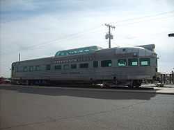
Maricopa is currently the closest stop from Phoenix on Amtrak's Sunset Limited and Texas Eagle trains. The Maricopa depot opened in 2001, originally in a converted passenger rail car but now in a metal building.
Municipal organization
Maricopa is governed by a Council-Manager form of government. This type of government structure combines the political leadership of elected officials with the managerial experience of an appointed professional manager. The City Council and City Manager work as partners to direct and guide local government.
The Maricopa City Council consists of the Mayor and six City Council members. The Mayor is elected to serve a four-year term and the City Council members are elected to serve four-year terms on a rotating basis. City Council meetings are held on the first and third Tuesdays of the month.
There are 10 citizen advisory groups that guide the Maricopa City Council on a myriad of activity. They are the Board of Adjustment, Heritage District Advisory Committee, Industrial Development Authority Board, Merit Board, Parks, Recreation and Library Advisory Committee, Planning and Zoning Commission, Public Safety Personnel Retirement System Board, Transportation Advisory Committee and the Youth Council. Selection to these groups is by City Council action.
The City is organized into nine departments: the City Manager's Office, the City Clerk's Office, Community Services, Development Services, Economic Development, Finance, Fire, Human Services and the Police Department. More than 250 individuals work for the municipality.
Civic and nonprofit organizations
- F.O.R. Maricopa - local food bank
- Thunderbird Arena Community Council - TACC
- Maricopa Motorcycle Riders - Local Group of Riders, all bikes allowed
- Maricopa Gun Club- Local Gun Club
- Pet Social Worker / Tails of Hope Rescue - local animal rescue group
- Recycling Association of Maricopa (R.A.M.) - Community drop-off recycling
Education facilities
Public School District
Public Elementary School
- Butterfield Elementary School
- Maricopa Elementary School
- Pima Butte Elementary School
- Saddleback Elementary School
- Santa Cruz Elementary School
- Santa Rosa Elementary School
Public Middle School
- Desert Wind Middle School
- Maricopa Wells Middle School
Public High School
In addition to the Maricopa Unified School District, there are several charter schools located in Maricopa.
- Legacy Traditional School
- Graysmark Academy
- Sequoia Pathway Academy
- Leading Edge Academy
- Camino Montessori School
Notable people
- Antony Hämäläinen former vocalist for the Swedish Melodic Death Metal band Nightrage and current Meridian Dawn singer.[13]
- Joshua Fourrier, nationally syndicated radio talk show host.[14]
- John Wayne (a famous actor) lived in a house in Maricopa before getting his mansion.
Notes
- ↑ "American FactFinder". United States Census Bureau. Retrieved 2014-06-19.
- ↑ 2.0 2.1 2.2 "Population Estimates". United States Census Bureau. Retrieved 2014-06-19.
- ↑ Citation?
- ↑ Reflections of a Desert Town, Patricia Brock
- ↑ http://www.maricopachamber.org/futureresident/history.php
- ↑ http://www.inmaricopa.com/COMMUNITY/History/tabid/131/Default.aspx
- ↑ "U.S. Census Data". United States Census Bureau. 2011-03-10. Retrieved 2011-03-10.
- ↑ "US Gazetteer files: 2010, 2000, and 1990". United States Census Bureau. 2011-02-12. Retrieved 2011-04-23.
- ↑ http://factfinder2.census.gov/faces/tableservices/jsf/pages/productview.xhtml?pid=DEC_10_DP_G001&prodType=table
- ↑ "Monthly Averages for Maricopa, AZ". Weather.com. 2010. Retrieved 2012-09-17.
- ↑ United States Census Bureau. "Census of Population and Housing". Retrieved June 19, 2014.
- ↑ http://factfinder2.census.gov/faces/tableservices/jsf/pages/productview.xhtml?pid=DEC_10_DP_DPDP1&prodType=table
- ↑ Kelly, Liz. Bristol Palin headed to Arizona
- ↑ Compete Sports Radio Network. AZCentral.com, March 1, 2011. Retrieved 2011-03-02.
External links
| Wikimedia Commons has media related to Maricopa, Arizona. |
- City of Maricopa
- Maricopa Chamber of Commerce
- InMaricopa.com - local news website - Founded in 2004
- Maricopa Monitor - Twice a week newspaper
- "Copa Report" - local News Aggregation website - Founded in 2014
- WikiSatellite view of Maricopa at WikiMapia
- Maricopa Community News - Local News, Events, and Commentary
- Maricopa Off Road Club
| |||||||||||||||||||||||||||||||||||||

| ||||||||||||||||||||||||||||||