Marengo County, Alabama
| Marengo County, Alabama | |
|---|---|
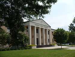 Marengo County Courthouse in Linden | |
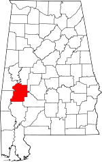 Location in the state of Alabama | |
 Alabama's location in the U.S. | |
| Founded | February 6, 1818 |
| Named for | Battle of Marengo[1] |
| Seat | Linden |
| Largest city | Demopolis |
| Area | |
| • Total | 983 sq mi (2,546 km2) |
| • Land | 977 sq mi (2,530 km2) |
| • Water | 5.8 sq mi (15 km2), 0.6% |
| Population | |
| • (2010) | 21,027 |
| • Density | 22/sq mi (8/km²) |
| Congressional district | 7th |
| Time zone | Central: UTC-6/-5 |
Marengo County is a county of the U.S. state of Alabama. As of the 2010 census, the population was 21,027.[2] The largest city is Demopolis and the county seat is Linden.[1] It is named in honor of a battlefield near Turin, Italy, where the French Consul Bonaparte defeated the Austrians on June 14, 1800.
History
Marengo County was created by the Alabama Territorial legislature on February 6, 1818, from land acquired from the Choctaw Indians by the Treaty of Fort St. Stephens on October 24, 1816.[3] The name of the county commemorates Napoleon's victory at the Battle of Marengo over the Austrian armies on June 14, 1800.[1] This name was chosen as a compliment to the first Caucasian settlers, exiled French Bonapartists who in 1817 settled the area around Demopolis in an effort to establish a Vine and Olive Colony.[3][4] The county seat was originally known as the Town of Marengo, but in 1823 the name was changed to Linden.[1] Linden is a shortened version of Hohenlinden, scene of the Battle of Hohenlinden, another French victory in Bavaria on December 3, 1800.[1]

Situated in Alabama's Black Belt and having a naturally rich soil, the county became home to numerous cotton plantations and consequently a large number of slaves.[3] In 1860 the population consisted of 24,409 slaves, 6761 free whites including 944 slave owners, and just 1 "free person of color" for a total combined population of 31,171.[5] At this time there were 778 farms in the county.[5] Demopolis was home to the fourth oldest Jewish congregation in Alabama, B'nai Jeshurun. It was established in 1858.[6] After the American Civil War, the economy continued to be based on agriculture with the former plantations turning to sharecropping.[3]
The population began to diminish rapidly after World War II, with people leaving the farms for manufacturing jobs elsewhere.[3] The former cotton fields were gradually converted to pastures for cattle and horses, woodlands for timber, and commercial catfish ponds for grain fed catfish.[3] Beginning in the 1960s industry began to move into the area and the working force came to be employed by paper mills, lumber mills, and chemical plants.[3] Courthouse fires occurred in 1848 and 1965, but most of the courthouse records were in a vault and thus largely saved in both instances.[1]
Geography

Marengo County is situated in the west-central area of the state.[1] According to the U.S. Census Bureau, the county has a total area of 983 square miles (2,550 km2), of which 977 square miles (2,530 km2) is land and 5.8 square miles (15 km2) (0.6%) is water.[7] The entire western county border is formed by the Tombigbee River and a small northwestern portion is formed by the Black Warrior River.
Major highways
 U.S. Highway 43
 U.S. Highway 80
 State Route 10
 State Route 25
 State Route 28
 State Route 69
Adjacent counties
- Hale County (north)
- Perry County (northeast)
- Dallas County (east)
- Wilcox County (southeast)
- Clarke County (south)
- Choctaw County (southwest)
- Sumter County (northwest)
- Greene County (north-northwest)
Demographics
| Historical population | |||
|---|---|---|---|
| Census | Pop. | %± | |
| 1820 | 2,933 | — | |
| 1830 | 7,700 | 162.5% | |
| 1840 | 17,264 | 124.2% | |
| 1850 | 27,831 | 61.2% | |
| 1860 | 31,171 | 12.0% | |
| 1870 | 26,151 | −16.1% | |
| 1880 | 30,890 | 18.1% | |
| 1890 | 33,095 | 7.1% | |
| 1900 | 38,315 | 15.8% | |
| 1910 | 39,923 | 4.2% | |
| 1920 | 36,065 | −9.7% | |
| 1930 | 36,426 | 1.0% | |
| 1940 | 35,736 | −1.9% | |
| 1950 | 29,494 | −17.5% | |
| 1960 | 27,098 | −8.1% | |
| 1970 | 23,819 | −12.1% | |
| 1980 | 25,047 | 5.2% | |
| 1990 | 23,084 | −7.8% | |
| 2000 | 22,539 | −2.4% | |
| 2010 | 21,027 | −6.7% | |
| Est. 2013 | 20,155 | −4.1% | |
1790-1960[9] 1900-1990[10] 1990-2000[11] 2010-2013[2] | |||
As of the 2010 United States Census, there were 21,027 people residing in the county. 51.7% were Black or African American, 46.4% White, 0.3% Asian, 0.2% Native American, 0.1% Pacific Islander, 0.7% of some other race and 0.8% of two or more races. 1.7% were Hispanic or Latino (of any race).
In 2000 there were 22,539 people, 8,767 households, and 6,277 families residing in the county.[12] The population density was 23 people per square mile (9/km2). There were 10,127 housing units at an average density of 10 per square mile (4/km2).[12] The racial makeup of the county was 51.71% Black or African American, 47.28% White, 0.08% Native American, 0.18% Asian, 0.01% Pacific Islander, 0.25% from other races, and 0.47% from two or more races. 0.97% of the population were Hispanic or Latino of any race.[12]
There were 8,767 households out of which 34.70% had children under the age of 18 living with them, 48.40% were married couples living together, 19.40% had a female householder with no husband present, and 28.40% were non-families.[12] 26.50% of all households were made up of individuals and 12.10% had someone living alone who was 65 years of age or older.[12] The average household size was 2.55 and the average family size was 3.08.[12]
In the county the population was spread out with 28.50% under the age of 18, 8.00% from 18 to 24, 26.00% from 25 to 44, 22.90% from 45 to 64, and 14.60% who were 65 years of age or older.[12] The median age was 36 years.[12] For every 100 females there were 88.30 males.[12] For every 100 females age 18 and over, there were 82.20 males.[12]
The median income for a household in the county was $27,025, and the median income for a family was $35,475.[12] Males had a median income of $36,053 versus $19,571 for females.[12] The per capita income for the county was $15,308.[12] About 22.20% of families and 25.90% of the population were below the poverty line, including 33.70% of those under age 18 and 25.30% of those age 65 or over.[12]
Education
For the 2014-15 school year, the Marengo County School District is operating three K–12 schools, one each in Dixons Mills, Sweet Water. and Thomaston.[13] One former county school in the Demopolis area was closed by the school board following the 2013-14 school year. Demopolis and Linden have city-run school systems, the Demopolis City School District and Linden City Schools.[14] Private school education offerings include West Alabama Christian School in Demopolis and Marengo Academy est. 1969 in Linden.
Culture
Events
- Candlelight Evening at Gaineswood, part of Christmas in the Canebrake, in Demopolis[15]
- Christmas on the River in Demopolis[15]
- Faunsdale Biker Rally in Faunsdale[16]
- Alabama Crawfish Festival in Faunsdale[17]
- Harvest Festival in Demopolis[15]
- Historic Demopolis Spring Pilgrimage in Demopolis[15]
- Pepper Jelly Festival in Thomaston[18]
- Southern Literary Trail in Demopolis[15]
Places of interest
Marengo County is home to the Alabama Rural Heritage Center and Chickasaw State Park. The Tombigbee River and Black Warrior River form portions of the western and northern county borders and provide recreational opportunities. Marengo County has 28 sites listed on the National Register of Historic Places, one of which is also a National Historic Landmark.[19] Additionally, 19 sites are listed on the Alabama Register of Landmarks and Heritage.[20]
Communities

Cities
Towns
Unincorporated communities
- Aimwell
- Alfalfa
- Clayhill
- Consul
- Coxheath
- Dixons Mills
- Exmoor
- Half Acre
- Half Chance
- Hampden
- Hoboken
- Hugo
- Jefferson
- Lasca
- McKinley
- Magnolia
- Marengo
- Moores Valley
- Moscow
- Nanafalia
- Nicholsville
- Octagon
- Old Spring Hill
- Pin Hook
- Pope
- Putnam
- Rembert
- Salt Well
- Shiloh
- Siddonsville
- Surginer
- Vangale
- Vineland
- Wayne
Ghost town
See also
- National Register of Historic Places listings in Marengo County, Alabama
- Properties on the Alabama Register of Landmarks and Heritage in Marengo County, Alabama
References
- ↑ 1.0 1.1 1.2 1.3 1.4 1.5 1.6 "Alabama Counties: Marengo County". "Alabama Department of Archives and History". Retrieved 2007-11-30.
- ↑ 2.0 2.1 "State & County QuickFacts". United States Census Bureau. Retrieved May 16, 2014.
- ↑ 3.0 3.1 3.2 3.3 3.4 3.5 3.6 Marengo County Heritage Book Committee. The Heritage of Marengo County, Alabama, pages 1-4. Clanton, Alabama: Heritage Publishing Consultants, 2000. ISBN 1-891647-58-X
- ↑ Smith, Winston. Days of Exile: The Story of the Vine and Olive Colony in Alabama, page 9. Tuscaloosa, Alabama: W. B. Drake and Son, 1967.
- ↑ 5.0 5.1 "Census Data for the Year 1860". "Inter-University Consortium for Political and Social Research". Retrieved 2007-11-30.
- ↑ "Alabama". Encyclopedia of Southern Jewish Communities. Goldring / Woldenberg Institute of Southern Jewish Life. Retrieved 5 October 2010.
- ↑ "US Gazetteer files: 2010, 2000, and 1990". United States Census Bureau. 2011-02-12. Retrieved 2011-04-23.
- ↑ "U.S. Decennial Census". United States Census Bureau. Retrieved May 16, 2014.
- ↑ "Historical Census Browser". University of Virginia Library. Retrieved May 16, 2014.
- ↑ "Population of Counties by Decennial Census: 1900 to 1990". United States Census Bureau. Retrieved May 16, 2014.
- ↑ "Census 2000 PHC-T-4. Ranking Tables for Counties: 1990 and 2000" (PDF). United States Census Bureau. Retrieved May 16, 2014.
- ↑ 12.0 12.1 12.2 12.3 12.4 12.5 12.6 12.7 12.8 12.9 12.10 12.11 12.12 12.13 "Fact Sheet: Marengo County 2000". "U.S. Census Bureau". Retrieved 2007-11-30.
- ↑ "Schools". Marengo County Schools. School In Sites. Retrieved 2 October 2010.
- ↑ "Marengo County". Encyclopedia of Alabama. Auburn University. Retrieved 2 October 2010.
- ↑ 15.0 15.1 15.2 15.3 15.4 "Demopolis". Alabama Tourism Department - Official Web Site. Retrieved 6 December 2008.
- ↑ "Faunsdale Biker Rally - Alabama's wildest biker event". "Bama Rides". 2008-04-26. Retrieved 2008-10-07.
- ↑ "Annual Faunsdale Crawfish Festival". Alabama Tourism Department - Official Web Site. Retrieved 6 December 2008.
- ↑ "Rural Heritage Day & Pepper Jelly Festival, 2nd". Alabama Tourism Department - Official Web Site. Retrieved 6 December 2008.
- ↑ "National Register Information System". National Register of Historic Places. National Park Service. 2008-04-15.
- ↑ "The Alabama Register of Landmarks & Heritage". preserveala.org. Alabama Historical Commission. May 31, 2011. Archived from the original (PDF) on June 6, 2011. Retrieved 6 June 2011.
 |
Greene County | Greene County and Hale County | Perry County | |
| |
Dallas County | |||
| ||||
| | ||||
| Choctaw County | Clarke County | Wilcox County |
| |||||||||||||||||||||||||||||
| ||||||||||||||||||||||||||||||||||
Coordinates: 32°14′31″N 87°47′22″W / 32.24194°N 87.78944°W