Mapai, Mozambique
| Mapai | |
|---|---|
 | |
 Mapai | |
| Coordinates: 22°43′50″S 32°03′30″E / 22.73056°S 32.05833°E | |
| Country |
|
| Provinces | Gaza Province |
| Elevation | 237 m (778 ft) |
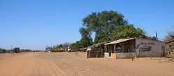
Mapai is a small town in southern Mozambique. It is a semi-arid region, with a dry climate and vegetation dominated by mopane (Colophospermum mopane) and galleries of ironwood (Androstachys johnsonii).
Transport
Mapai is served by a station of the southern railway line which runs between Maputo and the Zimbabwe border at Chicualacuala. It is also an important road crossing, with the Chicualacuale-Maputo road meeting the road from Pafuri and the road to Banhine National Park.
Tourism
Given its location between Limpopo National Park, Gonarezhou National Park and Banhine National Park, Mapai is set to form an important hub for the Great Limpopo Transfrontier Park.
History
In colonial times, Mapai was a popular hunting destination with well-known South African personalities including Jan Smuts, Ben Schoeman, Victor Verster and Judge Louis Weiers, as well as, world renowned ecologist Paul Dutton visiting. Mapai was also the seat of the powerful Western Native Labour Association, which supplied South African mines with labour, and N’Gala Limited company, trading mainly in cattle.
In June 1976 the Selous Scouts, a Rhodesian special operations unit, launched a raid on the ZANLA transit camp in Mapai and Chicualacuala. The area again came under attack on October 31 of 1976.[1] It was again the site of fierce fighting during Operation Uric in the final months of the Rhodesian Bush War.
See also
References
- ↑ Cilliers, J.K., (1984), Counter-insurgency in Rhodesia, p.177, Routledge, Retrieved on June 14, 2008
Coordinates: 22°43′50″S 32°03′30″E / 22.73056°S 32.05833°E