Manning, Oregon
| Manning | |
|---|---|
| Unincorporated community | |
|
Sign and highway in Manning | |
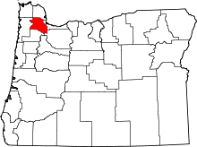
 Manning Location within the state of Oregon | |
| Coordinates: 45°39′54″N 123°9′45″W / 45.66500°N 123.16250°WCoordinates: 45°39′54″N 123°9′45″W / 45.66500°N 123.16250°W | |
| Country | United States |
| State | Oregon |
| County | Washington |
| Time zone | Pacific (PST) (UTC-8) |
| • Summer (DST) | PDT (UTC-7) |
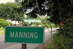
Manning is an unincorporated community in Washington County, Oregon, United States on the Sunset Highway (U.S. Route 26/Oregon Route 47).
Manning was named for Martin Manning, who took up a land claim there in 1865.[1] Manning post office was established in 1890.[1]
The Banks–Vernonia State Trail, a rail trail conversion, passes through Manning.
The NorthWest POINT offers twice-daily roundtrip intercity bus service between Portland and Astoria with a flag stop in Manning.[2]
References
- ↑ 1.0 1.1 McArthur, Lewis A.; Lewis L. McArthur (2003) [1928]. Oregon Geographic Names (Seventh Edition ed.). Portland, Oregon: Oregon Historical Society Press. p. 608. ISBN 0-87595-277-1.
- ↑ http://www.northwest-point.com/
External links
- Manning history from VanNatta Forestry
| |||||||||||||||||||||||||||||