Manitou Incline
| Manitou Incline | |
|---|---|
|
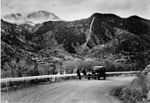
View from the Barr Trail Bailout, approximately two-thirds up the incline | |
| Length | Approx. .88 miles (1.42 km) |
| Location | Manitou Springs, Colorado |
| Trailheads | Barr Trail |
| Use | Hiking |
| Elevation | |
| Highest point | Peak, 8,590 feet (2,620 m) |
| Lowest point | Base, 6,500 feet (2,000 m) |
| Hiking details | |
| Trail difficulty | Extreme |
| Season | Year Round |
| Sights | Pikes Peak |
| Hazards |
Severe weather American Black Bear Venomous snake Mountain Lion |

| Manitou Springs, Colorado |
|---|
 |
|
Historic hotels, inns and lodging |
|
Attractions Cave of the Winds - Cliff Dwellings - Cog Railway - Miramont Castle - Pikes Peak - See also Manitou Springs Attractions |
|
Trails |
|
Other
|
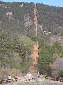
The Manitou Springs Incline, also known as the Manitou Incline or simply the Incline, is a popular hiking trail rising above Manitou Springs, Colorado, near Colorado Springs. The trail is the remains of a former 3 ft (914 mm) narrow gauge[1] funicular railway whose tracks washed out during a rock slide in 1990. The Incline is famous for its sweeping views and steep grade, as steep as 68% in places,[2] making it a fitness challenge for locals in the Colorado Springs area. The incline gains over 2,000 feet (610 m) of elevation in less than one mile.
History
The Incline was constructed under the ownership of Dr. Newton N. Brumback (1854-1923)[3] as a funicular in 1907, for the purpose of providing access to water tanks at the top of the mountain that would provide gravity fed water pressure to the cities of Manitou Springs and Colorado Springs.[4] Originally, the railroad was constructed to access the hydroelectric plant and service the water pipes, but shortly after its construction, the railway was opened as a tourist attraction. The Incline's original summit house was a rudimentary building constructed from left over materials from the Incline's construction, and burned down in 1914. The summit house was quickly rebuilt into a more elaborate, comfortable, and safer structure, offering shelter from storms and the elements. The 1914 structure remained until replaced by an updated summit house in 1958, which remained until it was dismantled after the Incline's closure. The Incline operated under the Pikes Peak Cog Railway until a rock slide in 1990 washed out the rail bed and the Cog Railway decided to not repair the tracks.
Legal battles
Though the Incline is a popular hike and fitness destination for locals, its existence since its public closing in 1990 has been controversial. Many locals and some National Forest Service officials wanted to keep it closed to allow it to revegetate, either by reseeding or allowing nature to reclaim the scar.[5] But the real controversy centered over parking rights at the base of the trail head, which is co-located with the Barr Trail trail head and the Pikes Peak Cog Railway. All three sit in the narrow Ruxton Canyon, and the popularity of the Incline has caused major parking conflicts with these entities.[2][6] The land through which the Incline passes on its ascent is owned by three entities: the bottom portion is owned by the City of Colorado Springs, the middle section is owned by the Pikes Peak Cog Railway and the top portion is owned by the US Forest Service.[7] The legal battles over the conversion of the Incline to a public hiking trail were finally overcome in January 2013, and the wranglings even went all the way to the United States Congress.[8]
Hiking Trail and Fitness Challenge
Since its closure as a railway in 1990, the trail has steadily grown in popularity as a hiking trail and fitness challenge.[6] The base of the Incline sits at 6,600 feet (2,000 m) and the trail climbs 2,000 feet (610 m) in just over 3⁄4 mile (1.2 km). Parts of the trail are extremely broken and steep and will require even the fittest of hikers or trail runners to scramble over the broken rocks and steep trail. Sections of the trail have exposed pipe from the days when the Incline was a hydroelectric utility system. Hiking the trail should not be undertaken by the physically unfit, as there is no vehicle access to the trail and anyone injured or suffering a medical emergency will have to walk or be carried down by other hikers. At the top of the Incline, there is a tie-in to the Barr Trail that allows for hikers to descend without going back down the Incline, which is considered bad form, especially during busier times of the day.[9] Due to the close proximity to the large and active population center of Colorado Springs, the large military population of nearby Army and Air Force bases, and the US Olympic Training Center, the Incline has become a wildly popular fitness destination for those craving an intense cardio workout.[10][11][12]

About 2/3 of the way up, a Barr Trail switchback passes just a few yards from the Incline, and there is a pathway that allows those who wish to exit the Incline the opportunity to take the Barr Trail back down. Locals refer to this point as the 'Bailout' or the 'Wimpout' point. The Incline is at its steepest grade just after the bailout for about another 200 feet (61 m), when it reaches the 'false summit', a semi-crest in the trail that obscured the true summit to hikers due to its extreme grade. Those who reach the false summit are about 3/4 of the way to the top, but still have several hundred feet to climb. When standing at the summit of the Incline, you will be looking East-Northeast towards Colorado Springs. If you travel south down the hill, you will pick up a trail that links into the Barr trail, a much less steep path down the mountain and the preferred descent route during busy trail hours.
Records
The New York Times has reported that the record for climbing the Incline is 16:42 by professional tri-athlete Mark Fretta. Fretta was sanctioned for anti-doping rules violations in 2012 by the US Anti Doping Agency resulting his record not being recognized by many incline enthusiasts.[12] Other notable times belong to Olympic Champion Apolo Ohno (17:45) and local running legend and twelve time champion of the Pikes Peak Marathon, Matt Carpenter (18:31).[13] Brandon Stapanowich owns the 'Inclinathon' record, completing 13 laps (26.2 miles) in 11 hours 46 minutes.[14] Stapanowich also completed the first ever UltraInclination, completing 22 laps of the Incline in 24 hours. He gained 44,000 ft in this endeavor.[15]
In 2011, Colorado Springs resident and type-I diabetic, Greg Cummings, became the first person to climb enough elevation in a single year to reach the height of the International Space Station, at 1.31 million vertical feet. During his effort, Greg hiked to the top of the Manitou Incline 601 times, and became the first person to achieve 500 ascents in a single year.[16] Before the Incline closed for repairs, on August 18, 2014, Greg hiked to the top of the Incline 1,400 times in 330 consecutive days, taking no days off. During the following 35 days, he finished his one year adventure by hiking various distances up Barr Trail. In total, he hiked over 2.8 million feet vertically (one way), more than twice the height of the International Space Station, setting a new World Record for vertical feet climbed in one year.[17]
The Incline has its own Facebook page, where locals post photos and records, including most annual trips up the incline, where the recent 2013 record is 719 trips in one year by Roger Austin of Colorado Springs. (719 is the local area code)[18] Also in 2012, local Colorado Springs resident and Incline legend Ed Baxter, 58, became the first known person to complete the 'Inclinathon', 26.52 miles in 13 consecutive trips up and down the Incline, taking him just over 13 hours.[19]
Images
-

Incline boxcar 1908
-
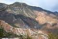
View of the Incline from the Red Mountain Trail
-

The Incline rising above Manitou Springs
-
View of the Manitou Incline from the base, May 2013
-

The Incline viewed from about 1/4 up from the trail head
References
- ↑ Zeitschrift Blickpunkt Straßenbahn (Tram Focus Magazine) - Trams of the World 2013
- ↑ 2.0 2.1 "Fight over Cog an uphill battle". theGazette.com. Retrieved 15 February 2013.
- ↑ "Dr. Newton N. Brumbach 1854-1923". findagrave.com. Retrieved 19 February 2013.
- ↑ History of Shenandoah County, Virginia. Genealogical.com. Retrieved 19 February 2013.
- ↑ "Manitou rail scar". theGazette.com. Retrieved 15 February 2013.
- ↑ 6.0 6.1 "Signs point to Incline deal". theGazette.com. Retrieved 15 February 2013.
- ↑ "Mt. Manitou scenic Incline (Railway)". InclineClub. Retrieved 15 February 2013.
- ↑ "Manitou Incline bill signed into law". The Colorado Springs Independent. Retrieved 15 February 2013.
- ↑ "Incline Rules". ManitouIncline.com. Retrieved 15 February 2013.
- ↑ "Opening the Manitou Incline, How we Got There". OutthereColorado.com. Retrieved 15 February 2013.
- ↑ "Olympic Training Towns: Colorado Springs". Sports Illustrated. Retrieved 15 February 2013.
- ↑ 12.0 12.1 "Up a Mountain, Olympic Dreams are Carved". New York Times. Retrieved 15 February 2013.
- ↑ "A pro shares easy-to-follow steps for your best Incline time". OutThereColorado.com. Retrieved 15 February 2013.
- ↑ "Inclinathon champ Brandon Stapanowich complete's 13 laps on Manitou Incline in 11 hours, 47 minutes!". pikespeaksports.us. Retrieved 5 May 2014.
- ↑ "Brandon Stapanowich nails 22 Incline ascents in 24 Hour UltraInclinathon". pikespeaksports.us. Retrieved 5 July 2014.
- ↑ Rappold, Scott (22 October 2011). "Springs man 'hikes' to the International Space Station". The Gazette. Retrieved 26 June 2013.
- ↑ "Colorado Springs man sets Manitou Incline record despite suffering from diabetes.". The Gazette. Retrieved January 17, 2015.
- ↑ "Q&A with Roger Austin, the man who knocked out 371 trips up the incline in 2012". PikesPeakSports.us. Retrieved 15 February 2013.
- ↑ "Ed Baxter climbs Manitou Incline 13 times in 13 hours, 15 minutes". PikesPeakSports.us. Retrieved 15 February 2013.
External links
Coordinates: 38°51′25″N 104°55′55″W / 38.856845°N 104.931956°W