Manitoba Highway 12
| ||||
|---|---|---|---|---|
| MOM's Way | ||||
| Route information | ||||
| Length: | 256 km (159 mi) | |||
| Major junctions | ||||
| South end: |
| |||
|
| ||||
| North end: | Grand Beach | |||
| Highway system | ||||
| ||||

Provincial Trunk Highway 12 (PTH 12) is a provincial highway in the Canadian province of Manitoba. It runs from the U.S. border (where it meets with Minnesota State Highway 313) to a dead end in Grand Beach. PTH 12 forms the Manitoba section of MOM's Way, a route from Thunder Bay to Winnipeg.[1] Except for a 22 kilometre stretch of four lanes between Steinbach and Highway 1, PTH 12 is a two-lane highway.
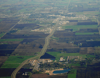
Highway 12 running south from Blumenort (lower) to Steinbach (upper) as a four lane road and can be seen exiting Steinbach to the upper part of the photo as a 2 lane highway.
Major intersections
This is the travel route for Provincial Trunk Highway 12 (PTH 12) from south to north.
| km | Municipality | Location | Interescting highway | Notes |
|---|---|---|---|---|
| 0 | US-Canada Border | PTH 12 begins highway travels west for the first 48 kilometres | ||
| 6 | R.M. of Piney | Middlebro | ||
| 21 | ||||
| 31 | South Junction | |||
| 48 | PTH 12 turns northwest | |||
| 62 | ||||
| 84 | R.M. of Stuartburn | PTH 12 turns west | ||
| 94 | R.M. of La Broquerie | Zhoda | PR 302 to Vita formerly PR 208 south | |
| 102 | ||||
| 113 | R.M. of Hanover | Sarto | PTH 12 turns north 3 km before junction | |
| 121 | ||||
| 128 | Steinbach | |||
| 133 | begin PR 311 west concurrence | |||
| 137 | Blumenort | end PR 311 west concurrence | ||
| 144 | R.M. of Ste. Anne | begin PR 210 east concurrence | ||
| 145 | Ste. Anne | end PR 210 east concurrence | ||
| 147 | ||||
| 152 | R.M. of Taché | |||
| 166 | R.M. of Springfield | Anola | ||
| 176 | R.M. of Brokenhead | |||
| 185 | ||||
| 187 | PTH 12 turns east begin PTH 44 east concurrence | |||
| 197 | Beausejour | PTH 12 turns north end PTH 44 east concurrence | ||
| 205 | ||||
| 218 | ||||
| 232 | R.M. of St. Clements | PTH 12 turns northwest | ||
| 237 | R.M. of Alexander | PTH 12 turns north begin PTH 59 north concurrence | ||
| 239 | ||||
| 247 | PTH 12 turns northwest end PTH 59 north concurrence | |||
| 251 | ||||
| 254 | Grand Marais | |||
| 256 | Grand Beach | PTH 12 ends | ||
See also
- List of Manitoba Expressways
References
Route map: Bing
| ||||||||||||||||||||||