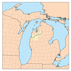
Manistee River
| Manistee River | |
|---|---|
 | |
| Origin |
Mancelona Township, Antrim County, Michigan |
| Mouth | 44°15′00″N 86°20′40″W / 44.25°N 86.34453°WCoordinates: 44°15′00″N 86°20′40″W / 44.25°N 86.34453°W |
| Length | 190 mi (310 km) |
| Source elevation | 1,250 ft (380 m) |
| Mouth elevation | 579 ft (176 m) |
| Basin area | 1,780 sq mi (4,600 km2) |
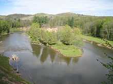
The Manistee River in the U.S. state of Michigan, runs 190 miles (310 km)[2] through the northern Lower Peninsula, through the villages of Sharon, Smithville, and Mesick, and enters Lake Michigan at Manistee. It is considered, like the nearby Au Sable River, to be one of the best trout fisheries east of the Rockies.
The river rises in the sand hills in southeastern Antrim County, on the border with Otsego County, about 6 miles (10 km) southeast of the town of Alba. These deep glacial sands provide it with a remarkably stable flow of clean cold water year round, making it a popular river for fishing as well as canoeing. Over the course of its length, it drops in elevation from around 1,250 to 579 feet (381 to 176 m), with an average stream gradient of about 2.9 feet per mile (55 cm/km).[3]
History
The name "Manistee" is from an Ojibwe word whose derivation is uncertain.[4] However, it may be from ministigweyaa, "river with islands at its mouth".[5][6] Historically, the upper river was renowned for its outstanding grayling fishery, among the finest in the world, as catches in excess of 1000 fish per weekend outing were commonly reported up until the 1880s, when extensive logging in the area ruined the habitat. Logging in the area commenced in earnest between 1880 and 1910, with peak production occurring in the 1890s. The river's relatively large size, stable flows, and dearth of cataracts or other difficult passages made it ideal for the transportation of lumber. During this period huge numbers of white pine logs, some as large as 6 feet (1.8 m) in diameter, were floated down the river to the port at Manistee and eventually on to the lumber markets of Grand Rapids, Milwaukee and Chicago, where the wood was used to build the cities and towns of the Midwestern United States. Some of these logs became trapped at various points on the river, and can be seen today along the river bottom, vestiges of a bygone era.
Activities

Today the river is used extensively for recreation, offering excellent conditions for canoeing, boating, and fishing. Having recovered from the ravages of the logging era, the river is again considered among the finest trout and salmon rivers in the country. Commercial navigation is possible in the lower stretches of the river below the Tippy Dam.
References
- ↑ "Manistee River". Geographic Names Information System. United States Geological Survey.
- ↑ U.S. Geological Survey. National Hydrography Dataset high-resolution flowline data. The National Map, accessed November 21, 2011
- ↑ Rozich, Thomas (June 1998), Manistee River Assessment, Michigan Department of Natural Resources, retrieved 2 July 2011
- ↑ Bright, William (2004). Native American Place Names of the United States. Norman: Oklahoma University Press, pg. 265
- ↑ County place names
- ↑ "Manistee County, Michigan". 50-State Learning Resource Guide. Retrieved 2009-04-07.