Manigod
| Manigod | |
|---|---|
|
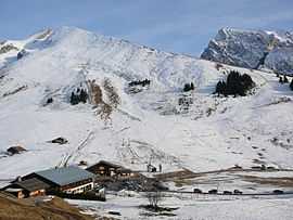
View of the Merdassier ski area | |
 Manigod | |
|
Location within Rhône-Alpes region  Manigod | |
| Coordinates: 45°51′42″N 6°22′14″E / 45.8617°N 6.3706°ECoordinates: 45°51′42″N 6°22′14″E / 45.8617°N 6.3706°E | |
| Country | France |
| Region | Rhône-Alpes |
| Department | Haute-Savoie |
| Arrondissement | Arrondissement of Annecy |
| Canton | Canton of Thônes |
| Intercommunality | Communauté de communes des Vallées de Thônes |
| Government | |
| • Mayor (2008–2014) | Bruno Sonnier |
| Area1 | 44.12 km2 (17.03 sq mi) |
| Population (1999)2 | 789 |
| • Density | 18/km2 (46/sq mi) |
| INSEE/Postal code | 74160 / 74230 |
| Elevation | 719–2,485 m (2,359–8,153 ft) |
|
1 French Land Register data, which excludes lakes, ponds, glaciers > 1 km² (0.386 sq mi or 247 acres) and river estuaries. 2 Population without double counting: residents of multiple communes (e.g., students and military personnel) only counted once. | |
Manigod is a commune in the Haute-Savoie department of the Rhône-Alpes region in south-eastern France.
The area
The linked area of Manigod consists of several different ski areas: La Croix Fry, Merdassier and Manigod Village, among others.
Village
The village itself is small and traditional with very few shops, all selling local produce such as home baked bread and locally made Reblochon.

Aravis valley from Manigod
Plateau de Beaugarde
Famous local walk with a view of Mont Blanc in Chamonix.
Geography
The Fier has its source in the commune.
Nearby
Nearby villages include Saint-Jean-de-Sixt, Thónes, Le Grand Bornand, La Clusaz and the larger Chamonix and Annecy.
See also
References
| Wikimedia Commons has media related to Manigod. |