Mangatarem, Pangasinan
| Mangatarem Baley na Mangatarem | ||
|---|---|---|
| Municipality | ||
 | ||
| ||
 Map of Pangasinan showing the location of Mangatarem | ||
.svg.png) Mangatarem Location within the Philippines | ||
| Coordinates: 15°47′N 120°18′E / 15.783°N 120.300°ECoordinates: 15°47′N 120°18′E / 15.783°N 120.300°E | ||
| Country |
| |
| Region | Ilocos (Region I) | |
| Province | Pangasinan | |
| District | 2nd district of Pangasinan | |
| Founded | 1837 | |
| Barangays | 82 | |
| Government[1] | ||
| • Mayor | Teodoro C. Cruz | |
| Area[2] | ||
| • Total | 317.50 km2 (122.59 sq mi) | |
| Population (2010)[3] | ||
| • Total | 69,969 | |
| • Density | 220/km2 (570/sq mi) | |
| Time zone | PST (UTC+8) | |
| ZIP code | 2413 | |
| Dialing code | 75 | |
| Income class | 1st class; partly urban | |

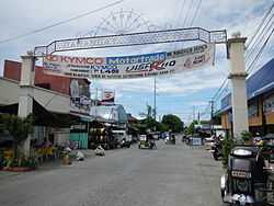
Mangatarem is a first class and largest municipality (in terms of land area) in the province of Pangasinan, Philippines. According to the 2010 census, it has a population of 69,969 people.[3]
Mangatarem is a Pangasinan word for "mango plantation" The town's name also came from the Pangasinan Phrase which means "mango and knife".[4]
The municipality is home to the Manleluag Spring Protected Landscape.
Barangays
Mangatarem is politically subdivided into 82 barangays.[2]
- Andangin
- Arellano Street (Pob.)
- Bantay
- Bantocaling
- Baracbac
- Peania Pedania (Bedania)
- Bogtong Bolo
- Bogtong Bunao
- Bogtong Centro
- Bogtong Niog
- Bogtong Silag
- Buaya
- Buenlag
- Bueno
- Bunagan
- Bunlalacao
- Burgos Street (Pob.)
- Cabaluyan 1st
- Cabaluyan 2nd
- Cabarabuan
- Cabaruan
- Cabayaoasan
- Cabayugan
- Cacaoiten
- Calumboyan Norte
- Calumboyan Sur
- Calvo (Pob.)
- Casilagan
- Catarataraan
- Caturay Norte
- Caturay Sur
- Caviernesan
- Dorongan Ketaket
- Dorongan Linmansangan
- Dorongan Punta
- Dorongan Sawat
- Dorongan Valerio
- General Luna (Pob.)
- Gomez (Pob.)
- Historia
- Lawak Langka
- Linmansangan
- Lopez (Pob.)
- Mabini (Pob.)
- Macarang
- Malabobo
- Malibong
- Malunec(original)
- Maravilla (Pob.)
- Maravilla-Arellano Ext. (Pob)
- Muelang
- Naguilayan East
- Naguilayan West
- Nancasalan
- Niog-Cabison-Bulaney
- Olegario-Caoile (Pob.)
- Olo Cacamposan
- Olo Cafabrosan
- Olo Cagarlitan
- Osmeña (Pob.)
- Pacalat
- Pampano
- Parian
- Paul
- Pogon-Aniat
- Pogon-Lomboy (Pob.)
- Ponglo-Baleg
- Ponglo-Muelag
- Quetegan (Pogon-Baleg)
- Quezon (Pob.)
- Salavante
- Sapang
- Sonson Ongkit
- Suaco
- Swag
- Tagac
- Takipan
- Talogtog
- Tococ Barikir
- Torre 1st
- Torre 2nd
- Torres Bugallon (Pob.)
- Umangan
- Zamora (Pob.)
Demographics
| Population census of Mangatarem | ||
|---|---|---|
| Year | Pop. | ±% p.a. |
| 1990 | 47,714 | — |
| 1995 | 53,603 | +2.20% |
| 2000 | 60,943 | +2.79% |
| 2007 | 65,366 | +0.97% |
| 2010 | 69,969 | +2.51% |
| Source: National Statistics Office[3][5] | ||
Tourism
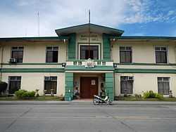
Mangatarem Town Hall
- Mangatarem Town Hall
- St. Raymond of Peñafort Parish Church (Mangatarem)
References
- ↑ "Municipalities". Quezon City, Philippines: Department of the Interior and Local Government. Retrieved 26 November 2012.
- ↑ 2.0 2.1 "Province: PANGASINAN". PSGC Interactive. Makati City, Philippines: National Statistical Coordination Board. Retrieved 26 November 2012.
- ↑ 3.0 3.1 3.2 "Total Population by Province, City, Municipality and Barangay: as of May 1, 2010". 2010 Census of Population and Housing. National Statistics Office. Retrieved 26 November 2012.
- ↑ "Mangatarem". Cities and Municipalities. Province of Pangasinan. Retrieved 26 November 2012.
- ↑ "Province of Pangasinan". Municipality Population Data. LWUA Research Division. Retrieved 5 September 2013.
External links
| Wikimedia Commons has media related to Mangatarem, Pangasinan. |
- Philippine Standard Geographic Code
- Philippine Census Information
- Local Governance Performance Management System
 |
Aguilar | |
Urbiztondo | |
| Santa Cruz, Zambales | |
|||
| ||||
| | ||||
| Candelaria, Zambales | |
San Clemente, Tarlac |
| ||||||||||||||||||||||