Mandurama, New South Wales
| Mandurama New South Wales | |
|---|---|
|
Olive Street, the main street of Mandurama, looking north | |
|
Mandurama | |
| Coordinates | 33°39′S 149°05′E / 33.650°S 149.083°ECoordinates: 33°39′S 149°05′E / 33.650°S 149.083°E |
| Population | 496 (2011 census)[1] |
| Established | 1839 |
| Postcode(s) | 2792 |
| Location | |
| LGA(s) | Blayney Shire |
| State electorate(s) | Bathurst |
| Federal Division(s) | Calare |
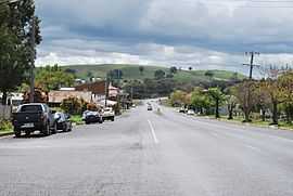
Mandurama is a village in the Blayney Shire, New South Wales, Australia. The site of the village and surrounding areas was home to the Wiradjuri people prior to settlement, and the name "Mandurama" is derived from their word for 'water holes'.[2] Mandurama is situated 259 kilometres west of Sydney, 59 kilometres southwest of Bathurst, and 47 kilometres northeast of Cowra on the Mid-Western Highway. Established in 1876 as a privately owned village for the workers of Thomas Icely's Coombing Park, it has since developed, along with nearby Lyndhurst into a modest service centre for the surrounding localities and farmland.
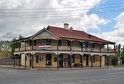
At the 2011 census, Mandurama and the surrounding area had a population of 496 people,[1] but is still home to a number of amenities, including a; general store and cafe; service station; a New South Wales Rural Fire Service station; primary school; number of churches; golf club; tennis court; hall, and; hotel. The village also retains a number of historic buildings, including two former bank premises, a former primary school, the Lincoln Theatre, and the Belubula Lodge.
Mandurama was also the central subject of the group of photographs known as the Mandurama Collection, now housed at the National Library of Australia.
See also
| Wikimedia Commons has media related to Mandurama, New South Wales. |
References
- ↑ 1.0 1.1 Australian Bureau of Statistics (31 October 2012). "Mandurama (State Suburb)". 2011 Census QuickStats. Retrieved 4 April 2015.
- ↑ "Mandurama". Geographical Names Register (GNR) of NSW. Geographical Names Board of New South Wales. Retrieved 26 October 2009.
| ||||||