Mandoto
| Mandoto | |
|---|---|
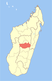
 Mandoto Location in Madagascar | |
| Coordinates: 19°34′S 46°17′E / 19.567°S 46.283°E | |
| Country |
|
| Region | Vakinankaratra |
| District | Batafo |
| Elevation[1] | 817 m (2,680 ft) |
| Population (2001)[2] | |
| • Total | 37,000 |
| • Ethnicities | Merina |
| Time zone | EAT (UTC3) |
Mandoto is a town and commune in Madagascar. It belongs to the district of Batafo, which is a part of Vakinankaratra Region. The population of the commune was estimated to be approximately 37,000 in 2001 commune census.[2]
Primary and junior level secondary education are available in town. The majority 80% of the population of the commune are farmers, while an additional 18% receives their livelihood from raising livestock. The most important crop is rice, while other important products are maize and cassava. Services provide employment for 2% of the population.[2]
Geography
This town is situated on the route nationale No.34 at 117 km West of Antsirabe and 129 km East of Miandrivazo.[3]
References and notes
- ↑ Estimated based on DEM data from Shuttle Radar Topography Mission
- ↑ 2.0 2.1 2.2 "ILO census data". Cornell University. 2002. Retrieved 2008-04-22.
- ↑ Atlas Mondial, France Loisir, page 158
| ||||||||||||||||||||||||||||
Coordinates: 19°34′S 46°17′E / 19.567°S 46.283°E