Mandohol Dam
| Mandohol Dam | |
|---|---|
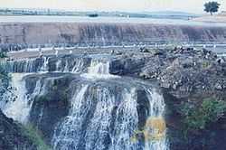 Fully filled Mandohol Dam | |
 | |
| Official name | Mandohol Dam |
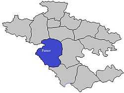
| Location | Karjule Hareshwar, Parner India |
| Coordinates | 19°11′56″N 74°18′28″E / 19.19889°N 74.30778°ECoordinates: 19°11′56″N 74°18′28″E / 19.19889°N 74.30778°E |
| Construction began | 1977 |
| Opening date | 1984 |
| Demolition date | N/A |
| Construction cost |
|
| Owner(s) | Government of Maharashtra, India |
| Operator(s) | Command Area Development Authority (CADA), Ahmednagar |
| Dam and spillways | |
| Type of dam | Earth-fill (Earthen) |
| Impounds | Mandohol River |
| Height | 27.07 m (88.8 ft) |
| Length | 739.0 m (2,424.5 ft) |
| Dam volume | 426 km3 (102 cu mi) |
| Reservoir | |
| Creates | Mandohol Lake |
| Total capacity | 8,780 km3 (2,110 cu mi) |
| Catchment area | 142.45 km2 (55.00 sq mi) |
| Surface area | 199.51 km2 (77.03 sq mi) |
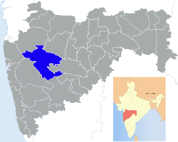
Mandohol Dam (Marathi: मांडोहोळ धरण), is an earth-fill dam on Mandohol River in Karjule Hareshwar village of Parner taluka in Ahmednagar district of state of Maharashtra in India.
Construction
The dam is constructed by Command Area Development Authority (CADA), Ahmednagar. It was constructed between 1977 and 1983, and was opened for irrigation purpose in 1984.[1]
Specifications
The height of the dam above lowest foundation is 27.07 m (88.8 ft) while the length is 739.0 m (2,424.5 ft). The volume content is 426 km3 (102 cu mi) and gross storage capacity is 11,300 km3 (2,700 cu mi).[2]
Purpose
- Irrigation
- Drinking water for neatest villages
See also
References
| ||||||||||||||||||||||||||||||||||||||||