Mandasa
| Mandasa మందస | |
|---|---|
| Village | |
|
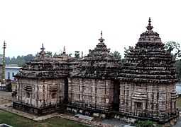
Mandasa Vasudeva Temple | |
 Mandasa Location in Andhra Pradesh, India | |
| Coordinates: 18°52′00″N 84°28′00″E / 18.8667°N 84.4667°ECoordinates: 18°52′00″N 84°28′00″E / 18.8667°N 84.4667°E | |
| Country |
|
| State | Andhra Pradesh |
| District | Srikakulam |
| Talukas | Mandasa |
| Languages | |
| • Official | Telugu |
| Time zone | IST (UTC+5:30) |
| PIN | 532 242 |
| Lok Sabha constituency | Srikakulam |
| Vidhan Sabha constituency | Palasa |
Mandasa is a village and a Mandal in Srikakulam district in the state of Andhra Pradesh in India.
Mandasa mandal is bordered by Sompeta mandal to the north, Palasa mandal to the south, Odisha state to the west and Bay of Bengal to the east. Manjusha was an older name of Mandasa.

Lord Vasudeva
Geography
Mandasa is located at 18°52′00″N 84°28′00″E / 18.8667°N 84.4667°E.[1] It has an average elevation of 31 meters (104 feet).
Demographics
According to Indian census, 2001, the demographic details of Mandasa mandal is as follows:[2]
- Total Population: 76,402 in 17,814 Households
- Male Population: 37,368 and Female Population: 39,034
- Children Under 6-years of age: 10,823 (Boys - 5,456 and Girls - 5,367)
- Total Literates: 38,425 38,425
Transport
Mandasa is connected with 'Mandasa Road' railway station on Howrah-Chennai mainline in East Coast Railway, Indian Railways.mahadevipuram is one of village in mandasa mandal
References
External links
- Welcome to Mandasa with image gallery
- History and People of mandasa with image gallery