Mandaluyong
| Mandaluyong | ||
|---|---|---|
| Highly-Urbanized City | ||
|
(From top, left to right): Mandaluyong City Hall, Cybergate skyline, San Felipe Neri Parish Church, EDSA Pioneer area, Monument of Youth | ||
| ||
|
Nickname(s): Shopping Capital of the Philippines Tiger City of the Philippines | ||
|
Motto: Sa Pagkaka-isa may Pag-unlad (English: In Unity there is Progress) | ||
 Location within Metro Manila | ||
.svg.png) Mandaluyong Location within the Philippines | ||
| Coordinates: 14°35′N 121°02′E / 14.58°N 121.03°ECoordinates: 14°35′N 121°02′E / 14.58°N 121.03°E | ||
| Country | Philippines | |
| Region | National Capital Region | |
| District | Lone District of Mandaluyong City | |
| Cityhood | 9 February 1994 | |
| Barangays | 27 | |
| Government[1] | ||
| • Mayor | Benjamin D.C. Abalos, Jr. (Lakas-CMD) | |
| • Vice Mayor | Edward Bartolome (Liberal) | |
| • Sangguniang Panlungsod |
Councilors
| |
| Area | ||
| • Total | 21.26 km2 (8.21 sq mi) | |
| Highest elevation | 213 m (699 ft) | |
| Population (2010)[2] | ||
| • Total | 328,699 | |
| • Density | 15,461/km2 (40,040/sq mi) | |
| Time zone | PST (UTC+8) | |
| Zip Code | 1550–1556 | |
| Dialing code | +63 (0)02 | |
| Website |
www | |


Mandaluyong is a city in the Philippines. It is one of the 16 cities that comprise Metro Manila, the National Capital Region of the country. To its west is located the country's capital, the City of Manila, to its north San Juan, Quezon City and Pasig to the east, and Makati to the south. According to the 2010 census, it has a population of 328,699.[2]
Among the many attractions in the city is the western half of the Ortigas Center, one of the major centers of business and commerce in the metropolis (the eastern half is in Pasig City). Found within the Mandaluyong portion of the Ortigas Center[3] is the main headquarters of the Asian Development Bank,[4][5] Banco De Oro, and the headquarters of San Miguel Corporation, Southeast Asia's largest food and beverage company. One of the most prominent pharmaceutical laboratories and factories, Unilab, is located here.[6]
Etymology
There are different stories on the origin of the name “Mandaluyong”.
One tells of how the place was abundant with a kind of tree called luyong, now more commonly known as '’anahaw (Saribus rotundifolius[7]), from which beautiful canes and furniture were made.
Another claims that the Spaniards named the place based on the report of a navigator named Acapulco, who saw the rolling hills frequently being lashed at by daluyong (“big waves from the sea”). This seems to confirm traditional pre-Hispanic stories that giant waves from the sea would meet the adjoining hills of the vast lowland, referred to as salpukan ng alon. Felix dela Huerta, a Franciscan historian, observed that the rolling topography of this land resembled giant waves of the sea. As with the etymological legends of many Philippine places, when the foreigners asked as to what the place was called, the locals answered with the description "madaluyong" ("undulating"), later transcribed by Spanish writers into "Mandaluyong" with the addition of an “n”.
Romantic residents, however, peddle the similarly formulaic legend of a Maharlika named Luyong who fell in love with Manda, the lovely daughter of a barangay chieftain. The chieftain had no personal liking for Luyong and forbade him Manda's hand. Luyong overcame this objection by winning a series of tribal contests which was the custom at the time. The couple settled thereafter in a place which was later called “Mandaluyong" by means of joining their names.
History
Mandaluyong formed part of what was once the Kingdom of Sapa of the Great Majapahit Empire around 1300. More than a century later, around 1470, it expanded and was called the Kingdom of Namayan. The vast kingdom comprised what are now Quiapo, San Miguel, Sta. Mesa, Paco, Pandacan, Malate and Sta. Ana in Manila, and Mandaluyong, San Juan, Makati, Pasay, Pateros, Taguig, Parañaque, and portions of Pasig and Quezon City up to Diliman.
Mandaluyong was first known as a barrio of Sta. Ana de Sapa which was part of the District of Paco, Province of Tondo. Named San Felipe Neri by the Spaniards in honour of the patron saint of Rome, it was separated from Sta. Ana de Sapa in 1841.
During the American Occupation, San Felipe Neri was consolidated with the municipality of San Juan del Monte. For several months in 1904, San Felipe Neri became the capital of Rizal Province. However in 1907, San Felipe Neri became an independent municipality when it was partitioned from San Juan, and renamed the Municipality of Mandaluyong by virtue of House Bill № 3836. It achieved city status in 1994.
Barangays

Mandaluyong is politically subdivided into 27 barangays.
| District | Barangay | Land Area (has.) |
Population (2007)[8] |
Population (2010)[2] |
|---|---|---|---|---|
| 1 | Addition Hills | 121.19 | 81,221 | 86,731 |
| 1 | Bagong Silang | 14.26 | 3,747 | 4,652 |
| 2 | Barangka Drive | 24.54 | 12,134 | 12,227 |
| 2 | Barangka Ibaba | 16.92 | 9,372 | 9,241 |
| 2 | Barangka Ilaya | 47.45 | 4,185 | 5,049 |
| 2 | Barangka Itaas | 17.21 | 11,212 | 11,061 |
| 2 | Buayang Bato | 7.26 | 999 | 1,340 |
| 1 | Burol | 2.78 | 2,322 | 2,606 |
| 1 | Daang Bakal | 17.34 | 2,980 | 3,931 |
| 1 | Hagdan Bato Itaas | 18.36 | 9,431 | 10,102 |
| 1 | Hagdan Bato Libis | 15.48 | 6,241 | 6,716 |
| 1 | Harapin Ang Bukas | 4.89 | 4,069 | 4,073 |
| 1 | Highway Hills | 105.12 | 18,682 | 22,684 |
| 2 | Hulo | 29.30 | 20,850 | 21,107 |
| 2 | Mabini-J. Rizal | 11.88 | 4,826 | 6,773 |
| 2 | Malamig | 29.52 | 6,898 | 7,007 |
| 1 | Mauway | 60.06 | 21,700 | 25,129 |
| 2 | Namayan | 30.60 | 4,846 | 5,706 |
| 1 | New Zañiga | 21.96 | 5,413 | 6,354 |
| 2 | Old Zañiga | 42.48 | 6,674 | 7,712 |
| 1 | Pag-Asa | 12.60 | 3,112 | 3,688 |
| 2 | Plainview | 115.92 | 24,706 | 24,396 |
| 1 | Pleasant Hills | 20.33 | 6,495 | 5,648 |
| 1 | Poblacion | 24.12 | 14,778 | 15,191 |
| 2 | San José | 3.18 | 7,629 | 7,041 |
| 2 | Vergara | 15.12 | 4,928 | 4,645 |
| 1 | Wack-Wack Greenhills | 294.48 | 6,126 | 7,889 |
Demographics

| Population Census of Mandaluyong | ||
|---|---|---|
| Year | Pop. | ±% p.a. |
| 1990 | 248,143 | — |
| 1995 | 286,870 | +2.75% |
| 2000 | 278,474 | −0.63% |
| 2007 | 305,576 | +1.29% |
| 2010 | 328,699 | +2.69% |
| Source: National Statistics Office[9] | ||
Economy


Mandaluyong is deemed as the "Tiger City" because of its vibrant business and economic activity. The city is home to a number of shopping centers, entertainment hubs, commercial establishments, high-rise offices, residential condominiums and hotels. The city is now one of the most important business and financial areas in the metropolis.[10]
Commercial activities
Like other cities in Metro Manila, Mandaluyong has its own share of commercial strips and a central business district. The former commercial area, consisting mostly of banks, offices and service establishments, stretch along public transport routes thereby serving both local consumers and passers-by from the neighboring localities. Major commercial strips of the city include the stretch of Boni Avenue, Shaw Boulevard, Libertad-Sierra Madre area, Kalentong, San Francisco, part of Martinez, Sgt. Bumatay towards Barangka Drive and Pinatubo towards EDSA. Mandaluyong's central business district is concentrated on the EDSA-Shaw-Pioneer area.[11]
Industrial activities
Industrial activities are mostly concentrated within the Shaw Boulevard-Pioneer area and along the Pasig River. Although prominent in the manufacture of foods, medicines and laboratory equipment, these industries are gradually declining in number, opting to relocate in newly developed industrial zones outside Metropolitan Manila. In the Pasig River area, particularly in Barangays Namayan and Mabini J. Rizal, areas formerly industrial are now the sites for residential subdivisions and townhouses. In the EDSA-Shaw-Pioneer area, the transformation is toward a more economically profitable and globally competitive commercial activity. And, since 2013, Mandaluyong is the home of one of the largest television networks in the country, TV5.[12]
Shopping malls
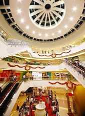
The City of Mandaluyong is known for being the "Shopping Capital of the Philippines", it is home to a cluster of shopping centers which stand side by side.[13][14] These shopping malls plays an important role in the economy of the city.
- SM Megamall - is a large shopping mall located in the Ortigas business district of Metro Manila. It one of the largest SM Supermall developed and operated by SM Prime Holdings, the largest mall operator in the Philippines owned by Henry Sy. The mall has two buildings interconnected with a bridge. The SM Megamall is the largest shopping mall in the country with a floor area of 500,000 m2 (5,400,000 sq ft).[15] The mall has a maximum capacity of 4 million people, it is as large as the Changi Airport Terminal 2 in Singapore.
- Shangri-La Plaza Mall - is an upscale shopping mall located at the Ortigas Center. It was established and developed by the Kuok Group of Companies, the owner of the worldwide chain of Shangri-La Hotels and Resorts.
- The Podium - an upscale shopping center located along ADB Avenue at the heart of the Ortigas Center, a major business and commercial district in Mandaluyong City. It was developed in December 2001 and officially opened in August 2002 as a joint project of Singaporean company, Keppel Land and SM Prime Holdings, the parent company of SM Supermalls.[16]
- Forum Robinsons - is a specialty mall within Cybergate, a modern business and residential complex at the corner of EDSA and Pioneer Street in Mandaluyong. The shopping center highlights information technology product categories.[17]
- St. Francis Square Mall - is one of the notable shopping center in the city, the mall is a modern low-rise building holding a 3,000 capacity auditorium and houses over 1,000 stalls and stores.
- Starmall EDSA-Shaw - located at the corner of one of the city's busiest roads: EDSA and Shaw Boulevard, with over 200 shops and dining outlets, digital cinemas and a bowling lane.[18]
- EDSA Central Pavilion - a shopping complex that contains a discount warehouse, food market, various shops and food chains.[19]
Transportation

Accessibility is among the city’s major advantages, the city is provided with good access roads to and from adjacent cities in the metropolis. The city is served by one of Metro Manila's main roads such as the Epifanio de los Santos Avenue (EDSA), Ortigas Avenue and Shaw Boulevard.[20]
Land
Mandaluyong is served by the Epifanio de los Santos Avenue (EDSA), Metro Manila's main thoroughfare. Considered as the heart of the metropolis, main roads such as the Ortigas Avenue and Shaw Boulevard provide inter-city linkages, while Boni Avenue and Martinez Street (C-3 Road) serve as alternate routes in the city.[20] Other major roads in Mandaluyong include Pioneer Street and Julia Vargas Avenue. Jeepneys are one of the most popular mode of public transportation for commuters in the city. Aside from jeepneys, tricycles and pedicabs are also one of the important modes of public transportation in Mandaluyong, especially on alleys around the city.
The city is also served by rail via the MRT-3. The line is located along the Epifanio de los Santos Avenue (EDSA). The city is served by three MRT-3 stations: Ortigas, Shaw Boulevard and Boni.
Water
The presence of the Pasig River stretching along the south border of Mandaluyong provides an alternative route and mode of public transportation mainly for cargo freight of industries along the river, and for commuters seeking for a faster and more direct route to and from the cities of Pasig and Manila.[20] The Pasig River Ferry Service has one station in the city.
Health
Mandaluyong has several private and public hospitals & health center, namely the privately owned Dr. Victor R. Potenciano Medical Center along EDSA and Unciano General Hospital, and the government hospital Mandaluyong City Medical Center. The city is also home to the Philippine’s prime psychiatric health institution, the National Center for Mental Health. Many residents, specifically the middle-to-upper class medical clientele visits the nearby Medical City in Ortigas Center.
The Dr. Victor R. Potenciano Medical Center is a tertiary care hospital that has a 189-bed capacity within its 10-storey hospital building.
Education

Three major colleges and universities are located in Mandaluyong, namely: Don Bosco Technical College, Jose Rizal University and Rizal Technological University (the only state-owned university in the city).
Don Bosco Technical College (DBTC or Don Bosco Mandaluyong) on Gen. Kalentong Street is a private Catholic higher-education institution, owned and operated by the Salesians of Don Bosco that offers all-boys grade school and high school education, and co-educational tertiary education.
A good number of city officials of Mandaluyong are alumni of Don Bosco,[21] including incumbent City Mayor, Hon. Benjamin Abalos, Jr. (HS '79);[22] former Vice Mayor, Hon. Renato Sta. Maria (HS '65);[23] City Councilors Edward Bartolome (HS '96),[24] Noel Bernardo (HS '79),[25] and Jonathan Abalos (HS '85).[26] Other notable alumni include "King of Pinoy Rap," Francis Magalona (HS '81);[27] and actor Ricky Davao (HS '78).[28]
Universities include:
- Arellano University – Plaridel Campus .
- Jose Rizal University
- Rizal Technological University
Other colleges in the city include the Our Lady of Guadalupe Colleges (specializing in Medicine and Nursing), STI and AMA (both specializing in Computer Technology education, both located on Shaw Boulevard), NAMEI Polytechnic Institute (specializing in Marine Sciences), and the International Baptist College.
The city is also home to Lourdes School of Mandaluyong (est. 1959), a Franciscan-Marian all-boys school, located in the Ortigas Center district managed by the OFM Capuchins; La Salle Green Hills (est. 1959), a private all-boys high school, managed by the De La Salle Brothers, located along Ortigas Avenue; and Saint Pedro Poveda College (est. 1960), another famous all-girls institution, offering pre-school, grade school, high school, and college education. Although the official school address is Quezon City, part of the lot Poveda's campus stands on is under Mandaluyong City.
Mandaluyong High School (est. 1977) is the oldest public high school in the city. City of Mandaluyong Science High School (est. 1996), a public science high school on E. Pantaleon St.
Local government
2013 Local Election Results:[29]
| Position | Candidate | Party | Total Votes |
|---|---|---|---|
| Representative Lone Legislative District |
Neptali M. Gonzales II | Liberal | |
| City Mayor | Benjamin D.C. Abalos Jr. | Lakas-CMD | |
| City Vice Mayor | Edward G. Bartolome | Liberal Party | |
| City Councilors | |||
| 1st Sanggunian District | |||
| Charisse Abalos | Lakas-CMD | | |
| Antonio D. Suva | Lakas-CMD | | |
| Ayla V. Alim | Liberal | | |
| Luisito E. Espinosa | Nationalist Peoples Coalition | | |
| Grace Antonio | United Nationalist Alliance | | |
| Alex I. Santos | Liberal Party | | |
| 2nd Sanggunian District | |||
| Cherry Lynn Pablo-Santos | Nationalist Peoples Coalition | | |
| Fernando S. Ocampo | Lakas-CMD | | |
| Roehl B. Bacar | Independent | | |
| Jesus C.Cruz | Liberal Party | | |
| Alexander C. Sta. Maria | Liberal Party | | |
| Francisco O. Esteban | Lakas-CMD | | |
See also
References
- ↑ "Cities". Quezon City, Philippines: Department of the Interior and Local Government. Retrieved 30 November 2012.
- ↑ 2.0 2.1 2.2 "Total Population by Province, City, Municipality and Barangay: as of May 1, 2010" (PDF). 2010 Census of Population and Housing. National Statistics Office. Retrieved 30 November 2012.
- ↑ "http://www.ortigas.com/map" Map and Directory, Ortigas Online. Retrieved on October 14, 2012.
- ↑ "Contacts." (Archive) Asian Development Bank. Retrieved on February 19, 2012. "6 ADB Avenue, Mandaluyong City 1550, Philippines"
- ↑ "How to Visit ADB." (Archive) Asian Development Bank. Retrieved on February 19, 2012.
- ↑ "UNILAB - MAIN OFFICE". Yellow Pages Philippines. Retrieved February 9, 2014.
- ↑ Marcial C. Amaro Jr., ed. (January–April 2010). "Anahaw" (PDF). Some Familiar Philippine Palms that Produce High Food Value and Tikog. Ecosystems Research and Development Bureau of the Philippine Department of Environment and Natural Resources. Retrieved 2013-04-01.
- ↑ "Final Results – 2007 Census of Population". Census.gov.ph. Retrieved 17 October 2011.
- ↑ "Population and Annual Growth Rates for The Philippines and Its Regions, Provinces, and Highly Urbanized Cities" (PDF). 2010 Census and Housing Population. National Statistics Office. Retrieved 2012-11-07.
- ↑ "Mandaluyong City Profile". City Government of Mandaluyong. Retrieved February 9, 2014.
- ↑ "Commercial Activities". City Government of Mandaluyong. Retrieved February 9, 2014.
- ↑ "Industrial Activities". City Government of Mandaluyong. Retrieved February 9, 2014.
- ↑ "Cities in Luzon and their Nicknames". Retrieved February 9, 2014.
- ↑ "Shopping capital". PhilStar. Retrieved February 9, 2014.
- ↑ "SM Megamall now PH’s largest mall". Inquirer Business. Retrieved February 9, 2014.
- ↑ Philippines President Arroyo opens The Podium in Manila published by Keppel Corporation; accessed February 10, 2014.
- ↑ "Forum Robinsons". Robinsons Malls. Retrieved February 9, 2014.
- ↑ "Mandaluyong Travel Guide: Shopping". City Government of Mandaluyong. Retrieved February 9, 2014.
- ↑ "Mandaluyong Travel Guide: Shopping". City Government of Mandaluyong. Retrieved February 10, 2014.
- ↑ 20.0 20.1 20.2 "Transportation". City Government of Mandaluyong. Retrieved February 10, 2014.
- ↑ "City of Mandaluyong : News Updates". Mandaluyong.gov.ph. 3 January 2011. Retrieved 17 October 2011.
- ↑ "Don Bosco High School". Bosco.arttickles.com. Retrieved 17 October 2011.
- ↑ http://www.bicc.org.ph/pub/resources/temp_images/Don%20Bosco%2009%20FINAL.pdf
- ↑ "Mandaluyong City Council : Edward Gabriel Bartolome". Mandaluyong.gov.ph. 4 November 1979. Retrieved 17 October 2011.
- ↑ "Mandaluyong City Council". Mandaluyong.gov.ph. Retrieved 17 October 2011.
- ↑ "www.donboscoforum.com". donboscoforum.com. Retrieved 17 October 2011.
- ↑ "Francis Magalona Succumbs to Cancer | A Filipina Mom Blogger". Aboutmyrecovery.com. Retrieved 17 October 2011.
- ↑ "Don Bosco Mandaluyong Batch 72 Photo Gallery by Jojo Vicencio – DU1VHY at". Pbase.com. Retrieved 17 October 2011.
- ↑ http://electionresults.ibanangayon.ph/res_reg7401000.html
External links
| Wikimedia Commons has media related to Mandaluyong City. |
- Mandaluyong – Official city website.
-
 Geographic data related to Mandaluyong at OpenStreetMap
 |
San Juan | Quezon City | | |
| Manila | |
Pasig | ||
| ||||
| | ||||
| Makati |
| ||||||||||||||