Manara, Ohio
| Manara, Ohio | |
|---|---|
| Unincorporated community | |
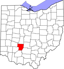
 Manara, Ohio Location of Manara, Ohio | |
| Coordinates: 39°36′09″N 83°18′47″W / 39.60250°N 83.31306°W | |
| Country | United States |
| State | Ohio |
| Counties | Fayette |
| Elevation[1] | 899 ft (274 m) |
| Time zone | Eastern (EST) (UTC-5) |
| • Summer (DST) | EDT (UTC-4) |
| ZIP code | 43145 |
| Area code(s) | 740 |
| GNIS feature ID | 1062871[1] |
Manara is an unincorporated community in Marion Township, Fayette County, Ohio, United States. It is located at 39°36′09″N 83°18′47″W / 39.60250°N 83.31306°WCoordinates: 39°36′09″N 83°18′47″W / 39.60250°N 83.31306°W,[2] at the intersection of Washington-Waterloo Road (Fayette County Highway 35) and Bloomingburg-New Holland Road (Fayette County Highway 27).[3]
-
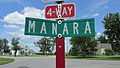
Manara community sign.
-
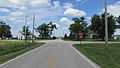
Intersection of Washington-Waterloo Road and Bloomingburg-New Holland Road in Manara, Ohio.
References
- ↑ 1.0 1.1 "US Board on Geographic Names". United States Geological Survey. 2007-10-25. Retrieved 2008-01-31.
- ↑ U.S. Geological Survey Geographic Names Information System: Manara, Ohio
- ↑ Rand McNally. The Road Atlas '06. Chicago: Rand McNally, 2006, 80.
| |||||||||||||||||||||||||||||||||