Manannah, Minnesota
| Manannah, Minnesota | |
|---|---|
| Unincorporated community | |
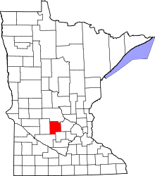
 Manannah, Minnesota Location of the community of Manannah | |
| Coordinates: 45°15′13″N 94°37′03″W / 45.25361°N 94.61750°WCoordinates: 45°15′13″N 94°37′03″W / 45.25361°N 94.61750°W | |
| Country | United States |
| State | Minnesota |
| County | Meeker |
| Township | Manannah Township |
| Elevation | 1,155 ft (352 m) |
| Time zone | Central (CST) (UTC-6) |
| • Summer (DST) | CDT (UTC-5) |
| ZIP code | 55329 and 56243 |
| Area code(s) | 320 |
| GNIS feature ID | 647430[1] |
Manannah is an unincorporated community in Manannah Township, Meeker County, Minnesota, United States. The community is located near the junction of Meeker County Roads 3 and 30. Nearby places include Eden Valley, Grove City, Paynesville, and Litchfield. State Highways 4 (MN 4) and 22 (MN 22) are also in the immediate area.
References
| |||||||||||||||||||||||||