Mallik Island
| Geography | |
|---|---|
| Location | Hudson Strait |
| Coordinates | 64°14′N 76°38′W / 64.23°N 76.63°WCoordinates: 64°14′N 76°38′W / 64.23°N 76.63°W |
| Archipelago | Canadian Arctic Archipelago |
| Country | |
| Nunavut | Nunavut |
| Region | Qikiqtaaluk |
| Demographics | |
| Population | Uninhabited |
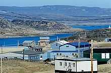

Mallik Island (variant: Mallikjuaq Island, meaning "big wave")[1] is one of the uninhabited Canadian arctic islands of Qikiqtaaluk Region, Nunavut, Canada. It is located in Hudson Strait between Baffin Island's Foxe Peninsula and Dorset Island. Mallik Island and Dorset Island are joined together by sand and boulders. Cape Dorset, an Inuit hamlet, is approximately 4.5 km (2.8 mi) away.[2]
Geography
Mallik Island has varying elevations, the western portion being the highest at 274 m (899 ft) above sea level.[3] In addition to low mountains, there are waterfalls and crystalline lakes.[4]
Fauna
Beluga whale, caribou, peregrine falcon, polar bear, seal, and snowy owl frequent the area.[1]
Flora
Its habitat is characterized by rounded hills and low tundra valleys, and includes tundra wildflowers.[1]
Territorial park
Mallikjuaq Territorial Park spans both Mallik Island and Dorset Island. It is notable for its Thule culture, Dorset culture, and Inuit archaeological sites dating back as far as 3,000 years.[4] From Cape Dorset, at low tide, the hike to Mallikjuaq Park takes approximately 45 minutes. It is also reachable by boat.[5]
References
- ↑ 1.0 1.1 1.2 "Mallikjuaq Territorial Park". New Parks North (dsp-psd.pwgsc.gc.ca) 10: 34. March 2001.
- ↑ "Mallik Island". travelingluck.com. Retrieved 2009-02-16.
- ↑ "Sector13.HudsonStrait". National Geospatial Intelligence Agency. pollux.nss.nima.mil. p. 14. Retrieved 2009-02-16.
- ↑ Canada. Lonely Planet. 2005. p. 839. ISBN 1-74059-773-7.
| ||||||||||||||||||||||||